Somersworth, New Hampshire

Last updated

Somersworth, New Hampshire
Main St., Somersworth, NH.jpg
Main Street c.1910
Somersworth City Seal.png
Strafford-Somersworth-NH.png
Location in Strafford County, New Hampshire
Coordinates: 43°15′45″N70°51′51″W / 43.26250°N 70.86417°W / 43.26250; -70.86417
CountryUnited States
State New Hampshire
County Strafford
Settled before 1700
Incorporated (town)1754
Incorporated (city) 1893
Government
   Mayor Matt Gerding
   City Council
Members
  • Martin Pepin
  • Kenneth S. Vincent
  • Robert G. Gibson
  • Crystal Paradis-Catanzaro
  • Richard R. Michaud
  • David A. Witham
  • Denis Messier
  • Nancie Cameron
  • Paul Goodwin
   City Manager Robert M. Belmore
Area
[1]
  Total10.00 sq mi (25.89 km2)
  Land9.80 sq mi (25.39 km2)
  Water0.20 sq mi (0.51 km2)
Elevation
204 ft (62 m)
Population
 (2020)
  Total11,855
  Density1,209.57/sq mi (467.00/km2)
Time zone UTC−5 (EST)
  Summer (DST) UTC−4 (EDT)
ZIP code
03878
Area code 603
FIPS code 33-69940
GNIS feature ID0870007
Website www.somersworth.com

Somersworth is a city in Strafford County, New Hampshire, United States. The population was 11,855 at the 2020 census. [2] Somersworth has the smallest area [3] and third-lowest population of New Hampshire's 13 cities. [4]

Contents

History

Somersworth, originally called "Sligo" after Sligo in Ireland, was settled before 1700 as a part of Dover. It was organized in 1729 as the parish of "Summersworth", meaning "summer town", because during that season the ministers preached here. It was set off and incorporated in 1754 by colonial governor Benning Wentworth, and until 1849 included Rollinsford. A clerical error at incorporation contracted the name to "Somersworth". It was incorporated as a city in 1893, before which it was also known as "Great Falls".
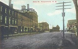
High Street, c. 1910 High Street, Somersworth, NH.jpg
High Street, c.1910

Situated where the Salmon Falls River drops 100 feet (30 m) over a mile, Somersworth early became a mill town, beginning with gristmills and sawmills. In 1822, the brothers Isaac and Jacob Wendell of Boston purchased for $5,000 a gristmill with its water rights at the Great Falls. They established the Great Falls Manufacturing Company, a textile business that expanded to include three mills for spinning thread and weaving cotton and woolen fabrics, specializing in "drillings, shirtings and sheetings". Throughout the 19th century, other expansive brick mill buildings, including a bleachery and dye works, were erected beside the river. The bleachery became the longest running textile operation in Somersworth. The building housed the operations that took the buff-colored fabric produced in the seven mills and transformed it into a sparkling white material that could be dyed or printed according to the buyer's wishes. [5] The gate house at the dam directed water as needed, regulating the flow either into the river or a company canal, which itself had gates sending it under the mill. Water power turned the wheels and belts that operated mill machinery. The railroad arrived in the early 1840s, before which goods were carted to Dover.

At first millworkers came from surrounding farms, including those in Berwick, Maine, directly across the bridge, many of whom were women. But as the need for labor grew, immigrants arrived from Ireland, and later Quebec. Brick tenement row houses were rented by the company to employee families, many of whose members worked in the mills beside their parents before passage of child labor laws. For relaxation, workers found entertainment at the Opera House or at Central Park, an amusement park beside Willand Pond. In the early 1870s, the Portsmouth, Great Falls & Conway Railroad began excursions to the White Mountains. The Electric Street Railway came in 1890, allowing trolley rides to York Beach, Maine.

In 1922, Somersworth was affected by the 1922 New England Textile Strike, shutting down the mills in the city over an attempted wage cut and hours increase. [6] [7]

But the New England textile industry went into decline later in the 20th century. Water power was replaced with newer forms of energy, and cotton could be manufactured where it grew, saving transportation costs. Labor was also cheaper in the South, which did not have New Hampshire's inventory tax that levied commodities like coal and cotton at the plants. The Great Depression sent many regional textile firms into bankruptcy, when some local facilities were adapted for shoemaking. The Great Falls Manufacturing Company's big mill was renovated for other uses in the 1980s, although the bleachery suffered a devastating fire in November 2003, which required assistance from 23 fire departments from New Hampshire and Maine. Aclara Technologies operates a factory (previously owned by General Electric Company [8] ) that manufactures state of the art electric meters for the energy business.

Somersworth's heyday was during the mill era. Although frequently overshadowed by the larger neighboring cities of Dover and Rochester, Somersworth retains a quantity of Victorian architecture from its prosperous age. Some antique residences, most notably within the historic district known as "The Hill", have been restored. The municipality is today largely a bedroom community for other cities and the Portsmouth Naval Shipyard. The upper end of High Street, however, continues to develop as a retail center, with several big-box chain stores.

One ship of the United States Navy was named after the city; the USS Somersworth (PCE(R)-849) was a PCE-842-class patrol craft. [9] Commissioned in April 1944, it was named after the city in February 1956, and remained in service until decommissioned in September 1965. [10] The ship was present at the surrender of Japan in Tokyo Bay at the end of World War II. [11]

Geography

Somersworth is located in eastern Strafford County at 43°15′14″N70°52′32″W / 43.25389°N 70.87556°W / 43.25389; -70.87556 (43.253783, −70.875499). [12]

According to the United States Census Bureau, the city has a total area of 10.0 square miles (25.9 km2), of which 9.8 square miles (25.4 km2) are land and 0.2 square miles (0.5 km2) are water, comprising 1.96% of the city. [3] Somersworth is bordered to the northeast by the Salmon Falls River, which is also the state boundary with Maine. The highest point in Somersworth is Prospect Hill rising just west of the city center, on which the city reservoir is built. The hill's elevation is approximately 310 feet (94 m) above sea level.

New Hampshire Route 9 (High Street) is the main road through the city, leading north into Berwick, Maine, and south into Dover. New Hampshire Route 108 passes through a western portion of the city, leading northwest to Rochester and south to Dover. New Hampshire Route 236 (West High Street) leads west out of downtown to NH 108.

Adjacent municipalities

Demographics

Historical population
CensusPop.Note
1790 943
1800 932−1.2%
1810 878−5.8%
1820 841−4.2%
1830 3,090267.4%
1840 3,2836.2%
1850 4,94350.6%
1860 4,787−3.2%
1870 4,504−5.9%
1880 5,58624.0%
1890 6,20711.1%
1900 7,02313.1%
1910 6,704−4.5%
1920 6,688−0.2%
1930 5,680−15.1%
1940 6,1368.0%
1950 6,92712.9%
1960 8,52923.1%
1970 9,0265.8%
1980 10,35014.7%
1990 11,2498.7%
2000 11,4772.0%
2010 11,7662.5%
2020 11,8550.8%
U.S. Decennial Census [2] [13] [ failed verification ]

As of the census of 2020, there were 11,855 people residing in the city. There were 5,325 housing units, of which 243, or 4.6%, were vacant. [14] The racial makeup of the city was 82.4% white, 1.8% African American, 0.3% Native American, 7.3% Asian, 0.05% Pacific Islander, 2.1% some other race, and 6.1% from two or more races. 4.3% of the population were Hispanic or Latino of any race. [2] [15]

As of the census of 2010, there were 11,766 people, 4,862 households, and 3,044 families residing in the city. There were 5,199 housing units, of which 337, or 6.5%, were vacant. The racial makeup of the city was 89.4% white, 1.4% African American, 0.3% Native American, 5.3% Asian, 0.02% Pacific Islander, 0.9% some other race, and 2.6% from two or more races. 2.5% of the population were Hispanic or Latino of any race. [16]

Of the 4,862 households in the city, 31.6% had children under the age of 18 living with them, 43.9% were headed by married couples living together, 13.5% had a female householder with no husband present, and 37.4% were non-families. 28.5% of all households were made up of individuals, and 10.2% were someone living alone who was 65 years of age or older. The average household size was 2.42, and the average family size was 2.95. [16]

23.2% of residents in the city were under the age of 18, 8.1% were from age 18 to 24, 29.2% were from 25 to 44, 27.7% were from 45 to 64, and 11.8% were 65 years of age or older. The median age was 37.8 years. For every 100 females, there were 91.3 males. For every 100 females age 18 and over, there were 89.3 males. [16]

For the period 2011–2015, the estimated median annual income for a household was $54,868, and the median income for a family was $66,086. Male full-time workers had a median income of $47,865 versus $36,935 for females. The per capita income for the city was $25,527. 13.6% of the population and 10.2% of families were below the poverty line, along with 20.0% of people under the age of 18 and 6.9% of people 65 or older. [17]

Education

The Somersworth School District consists of Somersworth High School (grades 9–12), Somersworth Middle School (grades 6–8), and two elementary schools, Idlehurst Elementary School and Maple Wood Elementary School.

Somersworth's first high school (pictured above) opened in 1850 and was located at 17 Grand Street. Hilltop School, built at the same location in 1927, replaced the original high school. Later it would be converted to an elementary school.

In 1999, after numerous fire code violations were identified with the Hilltop School by the New Hampshire State Fire Marshal, the City of Somersworth was granted waivers for a period of three years to address the state's concerns. Despite the failure of the school district to address the numerous code violations during the probation period, the waivers continued to be extended past their originally intended three-year period. In August 2007, the upper floors of the school were closed by the New Hampshire State Fire Marshall after the city neglected to fix code violations they were warned about in November 2006.

The closure of the upper floors came just weeks before neighborhood students were scheduled to return from summer vacation. This resulted in the start of school being delayed by over two weeks for Hilltop students. Three portable classrooms were brought in for "2 years" in 2007. Students were still occupying the three portable classrooms surpassing the time allotted as of August 18, 2010.

In the spring of 2007, the Somersworth School Board voted to build a new school to replace Hilltop. On February 17, 2009, the Somersworth City Council voted to approve bonding in the amount of $19.9 million for the construction of a new elementary school. The new school has been named Idlehurst, and has been functioning in the SAU 56 school system as of the start of the 2011–2012 school year.

In May 2019, Somersworth Middle School was awarded 2019 Middle School of the Year by the New Hampshire Department of Education. [18] The middle school, led by Principal Dana Hilliard, was awarded this award for excellence in education for its ability to engage students and support their social and emotional growth.

Notable people

Sites of interest

Transportation

Public transportation is provided by the Cooperative Alliance for Seacoast Transportation.

Related Research Articles

<span class="mw-page-title-main">Strafford County, New Hampshire</span> County in New Hampshire, United States

Strafford County is a county in the U.S. state of New Hampshire. As of the 2020 census, the population was 130,889. Its county seat is Dover. Strafford County was one of the five original counties identified for New Hampshire in 1769. It was named after William Wentworth, 2nd Earl of Strafford in the mistaken belief that he was the ancestor of governor John Wentworth – although they were distantly related, William had no descendants. The county was organized at Dover in 1771. In 1840, the size of the original county was reduced with the creation of Belknap County.

<span class="mw-page-title-main">South Berwick, Maine</span> Town in the state of Maine, United States

South Berwick is a town in York County, Maine, United States. The population was 7,467 at the 2020 census. South Berwick is home to Berwick Academy, a private, co-educational university-preparatory day school founded in 1791.

<span class="mw-page-title-main">Wakefield, New Hampshire</span> Town in New Hampshire, United States

Wakefield is a town in Carroll County, New Hampshire, United States. The population was 5,201 at the 2020 census. The town includes the villages of Wakefield Corner, East Wakefield, North Wakefield, Sanbornville, Union, Woodman and Province Lake. Wakefield Corner, popular with tourists, is a picturesque hilltop village of antique buildings. The state of Maine forms the eastern border of Wakefield.

<span class="mw-page-title-main">Nashua, New Hampshire</span> City in New Hampshire, United States

Nashua is a city in southern New Hampshire, United States. As of the 2020 census, it had a population of 91,322, the second-largest in northern New England after nearby Manchester. Along with Manchester, it is a seat of New Hampshire's most populous county, Hillsborough.

<span class="mw-page-title-main">Barrington, New Hampshire</span> Town in New Hampshire, United States

Barrington is a town in Strafford County, New Hampshire, United States. The population was 9,326 at the 2020 census, up from 8,576 at the 2010 census. The town is a woodland, farm and commuter town.

<span class="mw-page-title-main">Dover, New Hampshire</span> City in New Hampshire, United States

Dover is a city in Strafford County, New Hampshire, United States. The population was 32,741 at the 2020 census, making it the most populous city in the New Hampshire Seacoast region and the 5th most populous city in New Hampshire.

<span class="mw-page-title-main">Milton, New Hampshire</span> Town in New Hampshire, United States

Milton is a town in Strafford County, New Hampshire, United States. The population was 4,482 at the 2020 census. A manufacturing, resort and residential town, Milton includes the village of Milton Mills. The primary village in town, where 593 people resided at the 2020 census, is defined as the Milton census-designated place (CDP), and is located along New Hampshire Route 125 and the Salmon Falls River, just north of Route 75.

<span class="mw-page-title-main">Rochester, New Hampshire</span> City in New Hampshire

Rochester is a city in Strafford County, New Hampshire, United States. The population was 32,492 at the 2020 census, making it the 6th most populous city in New Hampshire. In addition to the downtown area, the city contains the villages of East Rochester, Gonic, and North Rochester. Rochester is home to Skyhaven Airport and part of Baxter Lake.

<span class="mw-page-title-main">Rollinsford, New Hampshire</span> Town in New Hampshire, United States

Rollinsford is a town in Strafford County, New Hampshire, United States. The population was 2,597 at the 2020 census. The main village in town was once known as "Salmon Falls Village".

<span class="mw-page-title-main">North Berwick, Maine</span> Town in Maine, United States

North Berwick is a town in York County, Maine, United States. The town was set off from Berwick in 1831, following South Berwick in 1814.

<span class="mw-page-title-main">Salmon Falls River</span> River in New Hampshire, United States

The Salmon Falls River is a tributary of the Piscataqua River in the U.S. states of Maine and New Hampshire. It rises at Great East Lake, Newichawannock Canal, and Horn Pond and flows south-southeast for approximately 38 miles (61 km), forming the border between York County, Maine, and Strafford County, New Hampshire.

<span class="mw-page-title-main">Seacoast Region (New Hampshire)</span>

The Seacoast Region is the southeast area of the U.S. state of New Hampshire that is centered around the city of Portsmouth. It includes the eastern portion of Rockingham County and the southern portion of Strafford County. At its narrowest definition, the region stretches 13 miles (21 km) along the Atlantic Ocean from New Hampshire's border with Salisbury, Massachusetts, to the Piscataqua River and New Hampshire's border with Kittery, Maine. The shoreline alternates between rocky and rough headlands and areas with sandy beaches. Some of the beaches are bordered by jetties or groins, particularly in the towns of Rye and Hampton. Most definitions of the Seacoast Region includes some inland towns as well, including the Great Bay area cities of Dover and Rochester, the college town of Durham, and areas as far west as Epping. Some definitions also include nearby portions of York County, Maine that are culturally aligned with the Portsmouth area rather than the Portland, Maine metropolitan area.

<span class="mw-page-title-main">New Hampshire Route 108</span> Highway in New Hampshire and Massachusetts

New Hampshire Route 108 is a 42.430-mile-long (68.284 km) north–south state highway in Rockingham and Strafford counties in southeastern New Hampshire. The southern terminus of NH 108 is at the Massachusetts state line in Plaistow. The northern terminus is at an intersection with New Hampshire Route 125 and New Hampshire Route 202A in downtown Rochester.

<span class="mw-page-title-main">New Hampshire Route 236</span> State highway in Strafford County, New Hampshire, US

New Hampshire Route 236 is a 2.589-mile-long (4.167 km) east–west state highway located entirely in the city of Somersworth, New Hampshire. Its western terminus is at an intersection with New Hampshire Route 108 west of downtown. Its eastern terminus is at the Maine state line, where the highway crosses the border into Berwick, Maine overlapped with New Hampshire Route 9. The roadway continues into Maine as Maine State Route 9.

<span class="mw-page-title-main">New Hampshire Route 9</span> State highway in New Hampshire, United States

New Hampshire Route 9 is a 109.910-mile-long (176.883 km) state highway located in southern New Hampshire. It runs across the state from west to east and is a multi-state route with Vermont and Maine, part of 1920s-era New England Interstate Route 9.

<span class="mw-page-title-main">Milton Mills, New Hampshire</span> Census-designated place in New Hampshire, United States

Milton Mills is a small village and census-designated place in the town of Milton, Strafford County, New Hampshire, United States. It had a population of 313 at the 2020 census. Milton Mills has a separate ZIP code (03852) from the rest of the town of Milton.

<span class="mw-page-title-main">New Hampshire's 4th State Senate district</span> American legislative district

New Hampshire's 4th State Senate district is one of 24 districts in the New Hampshire Senate. It has been represented by Democrat David Watters since 2012.

<span class="mw-page-title-main">Berwick, Maine</span> Town in the state of Maine, United States

Berwick is a town in York County, Maine, United States, situated in the southern part of the state beside the Salmon Falls River.

<span class="mw-page-title-main">Alvah T. Ramsdell</span> American architect

Alvah T. Ramsdell (1852–1928) was an American architect from Dover, New Hampshire. During his career he designed many substantial New Hampshire civic buildings.

<span class="mw-page-title-main">Old Somersworth High School</span> United States historic place

The Old Somersworth High School, also formerly the Hilltop Elementary School, is a historic school building at 17 Grand Street in Somersworth, New Hampshire. It is a three-story brick Georgian Revival building, constructed in 1927 on the site of New Hampshire's oldest high school. It was designed by Charles Greely Loring, and served as a high school until 1956 and an elementary school until 2007. The building was listed on the National Register of Historic Places in 2015.

References

  1. "ArcGIS REST Services Directory". United States Census Bureau. Retrieved September 20, 2022.
  2. 1 2 3 "Somersworth city, Strafford County, New Hampshire: 2020 DEC Redistricting Data (PL 94-171)". U.S. Census Bureau. Retrieved January 4, 2022.
  3. 1 2 "2021 U.S. Gazetteer Files – New Hampshire". United States Census Bureau. Retrieved January 4, 2022.
  4. "P1. Race: All county subdivisions in New Hampshire. 2020 DEC Redistricting Data (PL 94-171)". U.S. Census Bureau. Retrieved January 4, 2022.
  5. "Brief History of Somersworth". www.somersworth.com. Retrieved June 3, 2016.
  6. Foner, Philip Sheldon; Foner, Philip Sheldon (January 1, 1991). History of the labor movement in the United States. 9: The T.U.E.L. to the end of the Gompers era / by Philip S. Foner. New York: Intl Publ. pp. 19–31. ISBN   978-0-7178-0674-4.
  7. E. Tilden, Leonard (1923). "New England Textile Strike". Monthly Labor Review. 16 (5): 13–36 via JSTOR.
  8. LLC, Aclara Technologies. "Aclara Technologies LLC to Acquire GE Grid Solutions' Electricity Meters Business". www.prnewswire.com. Retrieved August 9, 2022.
  9. "USS Somersworth". somersworth.com. Retrieved December 23, 2021.
  10. "Somersworth (EPCE[R] 849)". navsource.org. Retrieved December 23, 2021.
  11. "Allied Ships Present in Tokyo Bay During the Surrender Ceremony, 2 September 1945". history.navy.mil. Retrieved December 23, 2021.
  12. "US Gazetteer files: 2010, 2000, and 1990". United States Census Bureau. February 12, 2011. Retrieved April 23, 2011.
  13. "Census of Population and Housing". Census.gov. Retrieved June 4, 2015.
  14. "H1. Occupancy Status; Somersworth city, Strafford County, New Hampshire: 2020 DEC Redistricting Data (PL 94-171)". U.S. Census Bureau. Retrieved May 4, 2023.
  15. "P2. Hispanic or Latino, and Not Hispanic or Latino by Race; Somersworth city, Strafford County, New Hampshire: 2020 DEC Redistricting Data (PL 94-171)". U.S. Census Bureau. Retrieved May 4, 2023.
  16. 1 2 3 "Profile of General Population and Housing Characteristics: 2010 Census Summary File 1 (DP-1): Somersworth city, New Hampshire". U.S. Census Bureau, American Factfinder. Archived from the original on February 13, 2020. Retrieved September 13, 2017.
  17. "Selected Economic Characteristics: 2011-2015 American Community Survey 5-Year Estimates (DP03): Somersworth city, New Hampshire". U.S. Census Bureau, American Factfinder. Archived from the original on February 13, 2020. Retrieved September 13, 2017.
  18. Stucker, Kyle. "Somersworth Middle School named NH's best". fosters.com. Retrieved November 13, 2019.

Further reading