Eaton, New Hampshire

Last updated

Eaton, New Hampshire
Town
CrystalLakeEatonNHSept2016.jpg
The "Little White Church" in Eaton Center overlooking Crystal Lake
Carroll-Eaton-NH.png
Coordinates: 43°54′34″N71°04′56″W / 43.90944°N 71.08222°W / 43.90944; -71.08222
Country United States
State New Hampshire
County Carroll
Incorporated 1766
Villages
  • Eaton Center
  • Snowville
Government
   Board of Selectmen
  • Richard Fortin
  • Edward Reilly
  • Greg Grinnell
Area
[1]
  Total25.6 sq mi (66.3 km2)
  Land24.3 sq mi (62.9 km2)
  Water1.3 sq mi (3.4 km2)  5.07%
Elevation
529 ft (161 m)
Population
 (2020) [2]
  Total405
  Density17/sq mi (6.4/km2)
Time zone UTC-5 (Eastern)
  Summer (DST) UTC-4 (Eastern)
ZIP code
03832
Area code 603
FIPS code 33-23380
GNIS feature ID0873587
Website www.eatonnh.org

Eaton is a town in Carroll County, New Hampshire, United States. The population was 405 at the 2020 census. [2] Eaton includes the villages of Eaton Center and Snowville.

Contents

History

Conway Street in Eaton c. 1910 Conway Street, Eaton, NH.jpg
Conway Street in Eaton c.1910

Eaton was incorporated in 1766 [3] by colonial Governor Benning Wentworth, and named for Governor Theophilus Eaton of Connecticut, a generous contributor to the funds needed to settle Massachusetts in 1630. He later formed a colony at New Haven, Connecticut, along with Reverend John Davenport and David Yale, great-grandfather of Yale University's founder, Elihu Yale.

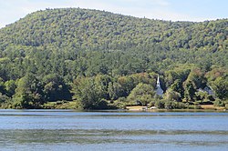
The "Little White Church" is a town landmark. The village of Snowville is named for the Snow family, who started a sawmill there in 1825. Waukeela, a summer camp for girls, has been in Eaton for 90 years as of 2011. It occupies 45 acres (180,000 m2) on Crystal Lake.

Geography

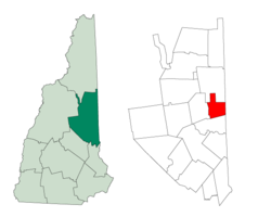
According to the United States Census Bureau, the town has a total area of 25.6 square miles (66.3 km2), of which 24.3 square miles (62.9 km2) are land and 1.3 square miles (3.4 km2) are water, comprising 5.07% of the town. [1] Conway Lake is on the northern boundary, and Crystal Lake is in the center. Eaton lies fully within the Saco River watershed. [4] The highest point in town is 1,730 feet (530 m) above sea level on its southern boundary, just north of the 1,806-foot (550 m) summit of Cragged Mountain. Eaton is bounded on the east by the Maine state line.

Adjacent municipalities

Demographics

Historical population
CensusPop.Note
1790 254
1800 38150.0%
1810 53540.4%
1820 1,071100.2%
1830 1,43233.7%
1840 1,71019.4%
1850 1,7431.9%
1860 780−55.2%
1870 657−15.8%
1880 629−4.3%
1890 514−18.3%
1900 365−29.0%
1910 3804.1%
1920 237−37.6%
1930 210−11.4%
1940 196−6.7%
1950 22112.8%
1960 151−31.7%
1970 22146.4%
1980 25615.8%
1990 36241.4%
2000 3753.6%
2010 3934.8%
2020 4053.1%
U.S. Decennial Census [2] [5] [6]

As of the census [7] of 2000, there were 375 people, 157 households, and 111 families residing in the town. The population density was 15.4 inhabitants per square mile (5.9/km2). There were 239 housing units at an average density of 9.8 per square mile (3.8/km2). The racial makeup of the town was 98.67% White, 0.27% African American, 0.27% Asian, and 0.80% from two or more races.

There were 157 households, out of which 29.9% had children under the age of 18 living with them, 61.1% were married couples living together, 7.6% had a female householder with no husband present, and 28.7% were non-families. 23.6% of all households were made up of individuals, and 7.0% had someone living alone who was 65 years of age or older. The average household size was 2.38 and the average family size was 2.85.

Eaton in 1909 Panorama, Eaton, NH.jpg
Eaton in 1909

In the town, the population was spread out, with 23.5% under the age of 18, 4.0% from 18 to 24, 21.6% from 25 to 44, 38.9% from 45 to 64, and 12.0% who were 65 years of age or older. The median age was 45 years. For every 100 females, there were 96.3 males. For every 100 females age 18 and over, there were 92.6 males.

The median income for a household in the town was $46,429, and the median income for a family was $53,750. Males had a median income of $31,458 versus $23,750 for females. The per capita income for the town was $21,122. About 3.6% of families and 7.2% of the population were below the poverty line, including 7.6% of those under age 18 and 15.9% of those age 65 or over.

Related Research Articles

<span class="mw-page-title-main">Oxford County, Maine</span> County in Maine, United States

Oxford County is a county in the state of Maine, United States. As of the 2020 Census, the county had a population of 57,777. Its county seat is the town of Paris. The county was formed on March 4, 1805, by the Massachusetts General Court in the Maine District from northerly portions of York and Cumberland counties. It borders the Canadian province of Quebec. Part of Oxford County is included in the Lewiston-Auburn, Maine metropolitan New England City and Town Area while a different part of Oxford County is included in the Portland-South Portland-Biddeford, Maine metropolitan New England City and Town Area.

<span class="mw-page-title-main">Hodgdon, Maine</span> Town in the state of Maine, United States

Hodgdon is a rural town in Aroostook County, Maine, United States. The town borders the province of New Brunswick, Canada to the east and Houlton to the north. Hodgdon's population was 1,290 at the 2020 census.

<span class="mw-page-title-main">Sebago, Maine</span> Town in Maine, United States

Sebago is a town in Cumberland County, Maine, United States. The population was 1,911 at the 2020 census. It is part of the Portland–South Portland–Biddeford, Maine metropolitan statistical area.

<span class="mw-page-title-main">Carthage, Maine</span> Town in the state of Maine, United States

Carthage is a town in Franklin County, Maine, United States. The population was 509 at the 2020 census.

<span class="mw-page-title-main">Gilead, Maine</span> Town in the state of Maine, United States

Gilead is a town in Oxford County, Maine, United States. Upon incorporation in 1804, it was named for the large quantity of Balm of Gilead trees in the town center. The population was 195 at the 2020 census.

<span class="mw-page-title-main">Porter, Maine</span> Town in the state of Maine, United States

Porter is a town in Oxford County, Maine, United States. It is included in the Portland-South Portland-Biddeford, Maine metropolitan New England City and Town Area. Porter includes Porter village and part of Kezar Falls. The population was 1,600 at the 2020 census.

Exeter is a town in Penobscot County, Maine, United States. The population was 963 at the 2020 census.

Garland is a town in Penobscot County, Maine, United States. The population was 1,026 at the 2020 census.

Danforth is a town in Washington County, Maine, United States. The town was named for proprietor Thomas Danforth. The population was 587 at the 2020 census. The town contains the villages of Danforth and Eaton. East Grand High School is located in Danforth.

<span class="mw-page-title-main">Pembroke, Maine</span> Town in the state of Maine, United States

Pembroke is a town in Washington County, Maine, United States. The population was 788 at the 2020 census. The town is home to a reversing falls on Mahar's Point.

<span class="mw-page-title-main">Chatham, New Hampshire</span> Town in New Hampshire, United States

Chatham is a town in Carroll County, New Hampshire, United States. The population was 341 at the 2020 census. It is located in the White Mountains, and except for the southeastern corner, all of Chatham is in the White Mountain National Forest. The town is home to the Cold River national forest campgrounds.

<span class="mw-page-title-main">Effingham, New Hampshire</span> Town in New Hampshire, United States

Effingham is a town in Carroll County, New Hampshire, United States. At the 2020 census, the town population was 1,691, up from 1,465 at the 2010 census. Effingham includes the villages of Effingham Falls, Effingham, Center Effingham, and South Effingham. Pine River State Forest is in the south.

<span class="mw-page-title-main">Freedom, New Hampshire</span> Town in New Hampshire, United States

Freedom is a town located in Carroll County, New Hampshire, United States. The population was 1,689 at the 2020 census, up from 1,489 at the 2010 census. The town's eastern boundary runs along the Maine state border. Ossipee Lake, with a resort and camps, is in the southwest of the town.

<span class="mw-page-title-main">Madison, New Hampshire</span> Town in New Hampshire, United States

Madison is a town in Carroll County, New Hampshire, United States. The population was 2,565 at the 2020 census. Madison includes the village of Silver Lake and the village district of Eidelweiss.

<span class="mw-page-title-main">Shelburne, New Hampshire</span> Town in New Hampshire, United States

Shelburne is a town in Coös County, New Hampshire, United States. The population was 353 at the 2020 census. It is located in the White Mountains, and part of the White Mountain National Forest is in the south. Shelburne is home to Leadmine State Forest. The Appalachian Trail crosses the town.

<span class="mw-page-title-main">Wentworth Location, New Hampshire</span> Township in Coos County, New Hampshire, United States

Wentworth Location is a township in Coös County, New Hampshire, United States. Its population was 28 at the 2020 census. It is part of the Berlin, NH-VT Micropolitan Statistical Area.

<span class="mw-page-title-main">Temple, New Hampshire</span> Town in New Hampshire, United States

Temple is a town in Hillsborough County, New Hampshire, United States. The population was 1,382 at the 2020 census. It is home to Temple Mountain State Reservation, formerly the Temple Mountain Ski Area.

<span class="mw-page-title-main">East Kingston, New Hampshire</span> Place in New Hampshire, United States

East Kingston is a town in Rockingham County, New Hampshire, United States. The population was 2,441 at the 2020 census.

<span class="mw-page-title-main">Snowville, Utah</span> Town in the state of Utah, United States

Snowville is a town in Box Elder County, Utah, United States. The population was 167 at the 2010 census.

<span class="mw-page-title-main">Norridgewock, Maine</span> Town in Maine, United States

Norridgewock is a town in Somerset County, Maine, United States. The population was 3,278 at the 2020 census.

References

  1. 1 2 "2021 U.S. Gazetteer Files – New Hampshire". United States Census Bureau. Retrieved November 1, 2021.
  2. 1 2 3 "Eaton town, Carroll County, New Hampshire: 2020 DEC Redistricting Data (PL 94-171)". U.S. Census Bureau. Retrieved November 1, 2021.
  3. Stackpole, Everett. History of New Hampshire vol. 2 . Retrieved May 8, 2022.
  4. Foster, Debra H.; Batorfalvy, Tatianna N.; Medalie, Laura (1995). Water Use in New Hampshire: An Activities Guide for Teachers. U.S. Department of the Interior and U.S. Geological Survey.
  5. "Census of Population and Housing". Census.gov. Retrieved June 4, 2016.
  6. "Heads of Families at the First Census of the United States Taken in the Year 1790: New Hampshire (PDF). [United States] Government Printing Office. 1907. p. 10. Archived (PDF) from the original on August 27, 2017. Retrieved May 10, 2022.
  7. "U.S. Census website". United States Census Bureau . Retrieved January 31, 2008.