Ferncroft, New Hampshire

Last updated
Ferncroft, New Hampshire
USA New Hampshire location map.svg
Red pog.svg
Ferncroft
Usa edcp location map.svg
Red pog.svg
Ferncroft
Coordinates: 43°54′44″N71°21′35″W / 43.91222°N 71.35972°W / 43.91222; -71.35972 Coordinates: 43°54′44″N71°21′35″W / 43.91222°N 71.35972°W / 43.91222; -71.35972
Country United States
State New Hampshire
County Carroll
Towns Albany, Sandwich
Elevation
1,148 ft (350 m)
Time zone UTC-5 (Eastern (EST))
  Summer (DST) UTC-4 (EDT)
Area code(s) 603
GNIS feature ID871878 [1]

Ferncroft is an unincorporated community lying mostly in the town of Albany in Carroll County, New Hampshire, United States. [2] Some of the roads and houses in Ferncroft stretch into the towns of Sandwich and Waterville Valley. [3] The hamlet is a widely spaced cluster of houses centered on several fields lying along the Wonalancet River on Ferncroft Road. [3]

Contents

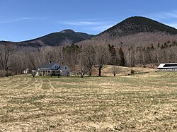
Ferncroft has about 50 seasonal residents and a few full-time residents residing in 11 houses and multiple barns and outbuildings. [2] [3] [4]

Ferncroft was named for the Ferncroft Family Inn which once stood in the area. The area became known as Ferncroft to differentiate it from nearby Wonalancet. [5] [6]

Location

Ferncroft lies 7 miles (11 km) northeast of North Sandwich and 7 miles (11 km) northwest of Tamworth, off New Hampshire Route 113A. [3] Ferncroft is located in a glen, dale, or dell, known as Birch Intervale. [7] It lies south of a cirque known as "The Bowl". [7] Mountains surround the hamlet on three sides, and Ferncroft Road is the only way in or out, aside from hiking trails. This makes the village rather inaccessible. In fact the closest town center by road is Tamworth, 7 miles away. The center of Albany, Ferncroft's main parent town, is 18.5 miles (29.8 km) away. [8] Some of the houses in Ferncroft lie within the Waterville Valley town limits; however, the center of Waterville Valley is 47 miles (76 km) and 1.5 hours away by car. [9]

Recreation

Ferncroft is a popular hiking center in summer, with several major trails beginning from a parking lot on the east side of Ferncroft Road. [10] The trails travel into the Sandwich Range Wilderness and are maintained by the Wonalancet Out-Door Club and United States Forest Service. [7] [10] [11] Mount Whiteface, Mount Passaconaway, Mount Wonalancet and Mount Paugus are just a few of the peaks easily accessible from Ferncroft.

In winter many shorter trails in the area are maintained and groomed by the Tamworth Outing Club for Nordic skiing. [11] Every February a 10-kilometer (6.2 mi) classic style Nordic ski race is held in Ferncroft on these trails, called the Wonalancet Wander. [11]

Confusion with Wonalancet

Ferncroft can often be confused with the neighboring village of Wonalancet in the town of Tamworth. During the time when the Ferncroft Inn was operating, Ferncroft was considered a part of Wonalancet village. [5] The general distinction today is that the area within Tamworth is known as Wonalancet, while the area in the remaining three towns of Albany, Sandwich and Waterville Valley is known as Ferncroft. [2] [5] [12] The Wonalancet Chapel and post office are located at the beginning of Ferncroft Road. [2]

Hiking trails in the Ferncroft area

Many other trails begin in nearby Whiteface village, Wonalancet and Fowler's Mill, leading to other peaks such as Mount Chocorua, Sandwich Dome and Mount Tripyramid. [10]

Related Research Articles

Albany, New Hampshire Town in New Hampshire, United States

Albany is a town in Carroll County, New Hampshire, United States. The population was 735 at the 2010 census.

Bartlett, New Hampshire Town in New Hampshire, United States

Bartlett is a town in Carroll County, New Hampshire, United States. The population was 2,788 at the 2010 census. Bartlett includes the unincorporated community of Glen as well as portions of the communities of Kearsarge and Intervale which the town shares with the neighboring town of Conway. It is set in the White Mountains and is surrounded by the White Mountain National Forest. It is home to the Attitash Mountain Resort and the Story Land theme park.

Dartmouth Outing Club

The Dartmouth Outing Club (DOC) is the oldest and largest collegiate outing club in the United States. Proposed in 1909 by Dartmouth College student Fred Harris to "stimulate interest in out-of-door winter sports", the club soon grew to encompass the College's year-round outdoor recreation and has had a major role in defining Dartmouth College.

Passaconaway Pennacook chieftain

Passaconaway, which translates to "Child of the Bear", was sachem of the Pennacook people in what is now northern New England in the United States.

New Hampshire Route 112 highway in New Hampshire

New Hampshire Route 112 is a 56.39-mile-long (90.75 km) east–west state highway in northern New Hampshire. The highway winds across the state, connecting Bath to Conway through the heart of the scenic and mountainous White Mountain National Forest.

New Hampshire Route 113 highway in New Hampshire

New Hampshire Route 113 is a 40.456-mile long (65.108 km) east–west state highway in east-central New Hampshire. NH 113 begins in the Lakes Region at an intersection with U.S. Route 3 and New Hampshire Route 25 in Holderness, and stretches eastward across the central part of the state, ending at an intersection with U.S. Route 302 in Conway, just a few miles west of the Maine border.

Mount Chocorua Mountain in New Hampshire, United States

Mount Chocorua is a 3,490 ft (1,060 m) mountain in the White Mountains of New Hampshire, the easternmost peak of the Sandwich Range. Although the mountain is not outstanding for its elevation, it is very rugged and has excellent views of the surrounding lakes, mountains, and forests. Mount Chocorua's bare summit can be seen from almost every direction and identified from many points throughout central New Hampshire and western Maine. Many hiking trails ascend the mountain. Scenic Chocorua Lake lies directly to the south.

Wonalancet, New Hampshire Unincorporated community in New Hampshire, United States

Wonalancet is an unincorporated community in the northwestern corner of the town of Tamworth in Carroll County, New Hampshire, United States. Many popular hiking trails into the Sandwich Range of the White Mountains have trailheads in the area, particularly in the locale known as Ferncroft, up a short spur road from Wonalancet.

The Swift River is an 8.3-mile-long (13.4 km) river located in eastern New Hampshire in the United States. It is a tributary of the Bearcamp River, part of the Ossipee Lake / Saco River watershed leading to the Atlantic Ocean. The Swift River is located only four miles south of the larger and longer Swift River which parallels the Kancamagus Highway in the White Mountain National Forest.

Defunct placenames are those no longer used officially.

Sandwich Range

The Sandwich Range is located in the White Mountains of New Hampshire in the United States, north of the Lakes Region and south of the Kancamagus Highway. Although the range is not outstanding for its elevation, it is very rugged and has excellent views of the surrounding lakes, mountains, and forests.

The Whiteface River is a 5.9-mile-long (9.5 km) river rising in the White Mountains of New Hampshire in the United States. Its waters flow by way of the Cold River, Bearcamp River, Ossipee Lake, the Ossipee River and the Saco River into the Gulf of Maine, an arm of the Atlantic Ocean.

The East Branch of the Whiteface River is a 1.9-mile (3.1 km) long (3.1 km) stream in the White Mountains of New Hampshire in the United States. It is a tributary of the Whiteface River, part of the Saco River watershed.

Wonalancet River river in the United States of America

The Wonalancet River is a 7.6-mile long (12.3 km) river located in the White Mountains of New Hampshire in the United States. Named after the 17 century Pennacook sachem Wonalancet, it is a tributary of the southern Swift River, part of the Bearcamp River / Ossipee Lake / Saco River watershed leading to the Atlantic Ocean.

Mount Passaconaway mountain in United States of America

Mount Passaconaway is a 4,043 ft (1,232 m) mountain in the Sandwich Range Wilderness of the White Mountain National Forest near the eastern boundary of Waterville Valley, New Hampshire. It is named after Passaconaway, a 16th-century sachem of the Pennacook tribe, whose name was also attached to a small village in Albany, where the northern trailhead is now located.

Waterville Valley Resort ski resort in Grafton County, New Hampshire, USA

Waterville Valley is a ski resort in the northeast United States, located in the White Mountain National Forest of New Hampshire. Built on Mount Tecumseh, with a summit elevation of 4,004 feet (1,220 m) above sea level, the ski trails extend to a high point on the south ridge of the mountain at 3,840 feet (1,170 m), offering a vertical drop of 2,020 feet (615 m). The ski area has 11 lifts, including two high-speed quads and is located in the town of the same name. The slopes primarily face east and northeast.

Mount Whiteface mountain in United States of America

Mount Whiteface is a 4,019 ft (1,225 m) mountain located in Grafton County, New Hampshire. The mountain is part of the Sandwich Range of the White Mountains. Whiteface is flanked to the northwest by Mount Tripyramid, and to the northeast by Mount Passaconaway. Whiteface is on the eastern border of the Sandwich Range Wilderness. To the east, between Whiteface, Passaconaway, and Mt. Wonalancet, lies The Bowl natural area, an unlogged cirque.

The Sleepers (New Hampshire) mountain in United States of America

The Sleepers are two mountain peaks, East Sleeper 3,855 ft (1,175 m) and West Sleeper 3,881 ft (1,183 m), located within the Sandwich Range Wilderness in Grafton County, New Hampshire. Part of the Sandwich Range of the White Mountains, they are flanked to the northwest by Mount Tripyramid, to the northeast by Mount Passaconaway, and to the southeast by Mount Whiteface. The Kate Sleeper Trail passes close by both peaks.

Wonalancet may refer to:

Mount Wonalancet is a 2,760 ft (840 m) mountain in the town of Waterville Valley, New Hampshire, overlooking the unincorporated communities of Wonalancet and Ferncroft. It is named after Wonalancet, a 17th century sachem of the Pennacook, a Native American people. Mount Wonalancet lies in Grafton County, immediately west of the Carroll County border, the county in which Ferncroft and Wonalancet are located.

References

  1. "Ferncroft". Geographic Names Information System . United States Geological Survey.
  2. 1 2 3 4 Johnson, Erin D., ed. History of New Hampshire Towns and Places. 2nd & 5th ed. Hanover, NH: Dartmouth Press, 1969-1999
  3. 1 2 3 4 MyTopo.com
  4. NH HomeTownLocator
  5. 1 2 3 Hunt, Elmur M. New Hampshire Town Names and Whence They Came. Peterborough, N.H.: Noone Falls Publishers, 1972.
  6. "Wonalancet". Dick & Sandy's World. Archived from the original on August 14, 2011. Retrieved May 27, 2011.
  7. 1 2 3 Wonalancet Out Door Club
  8. Town of Albany, New Hampshire
  9. "Town of Waterville Valley, New Hampshire". Archived from the original on 2011-05-18. Retrieved 2011-05-26.
  10. 1 2 3 White Mountain National Forest official website
  11. 1 2 3 Tamworth Outing Club
  12. Town of Sandwich, New Hampshire