
Albany is a town in Carroll County, New Hampshire, United States. The population was 759 at the 2020 census.

Sandwich is a town in Carroll County, New Hampshire, United States. Its population was 1,466 at the 2020 census. Sandwich includes the villages of Center Sandwich and North Sandwich. Part of the White Mountain National Forest is in the north, and part of Squam Lake is in the southwestern corner of the town. As such, Sandwich lies on the boundary between New Hampshire's Lakes Region and White Mountains Region. The Sandwich Range of the White Mountains lies partially within the town, as does the namesake Sandwich Mountain. The town is home to the Sandwich Fair, a popular agricultural fair that occurs every October.

Tamworth is a town in Carroll County, New Hampshire, United States. The population was 2,812 at the 2020 census. Tamworth includes the villages of Chocorua, South Tamworth, Wonalancet, and Whittier. The White Mountain National Forest is to the north. The town is home to Hemenway State Forest in the north and White Lake State Park in the southeast.

The White Mountain National Forest (WMNF) is a federally managed forest contained within the White Mountains in the northeastern United States. It was established in 1918 as a result of the Weeks Act of 1911; federal acquisition of land had already begun in 1914. It has a total area of 750,852 acres (303,859 ha). Most of the WMNF is in New Hampshire; a small part is in the neighboring state of Maine. Conservationist and community activist Katherine Sleeper Walden was instrumental in securing at-risk land for the forest, including thousands of acres in the region surrounding the locally famous Bowl near Wonalancet.

Mount Lafayette is a 5,249-foot (1,600 m) mountain at the northern end of the Franconia Range in the White Mountains of New Hampshire, United States. It lies in the town of Franconia in Grafton County, and appears on the New England Fifty Finest list of the most topographically prominent peaks in New England. The mountain's upper reaches are located in the alpine zone, an area where only dwarf vegetation exists due to the harsh climate.

New Hampshire Route 113 is a 40.456-mile long (65.108 km) east–west state highway in east-central New Hampshire. NH 113 begins in the Lakes Region at an intersection with U.S. Route 3 and New Hampshire Route 25 in Holderness, and stretches eastward across the central part of the state, ending at an intersection with U.S. Route 302 in Conway, just a few miles west of the Maine border.

Mount Chocorua is a 3,490 ft (1,060 m) mountain in the White Mountains of New Hampshire, the easternmost peak of the Sandwich Range. Although the mountain is not outstanding for its elevation, it is very rugged and has excellent views of the surrounding lakes, mountains, and forests. Being at the end of the range, its bare summit can be seen from almost every direction and identified from many points throughout central New Hampshire and western Maine, and it has been the subject of numerous works of art. Many hiking trails ascend the mountain. Scenic Chocorua Lake lies directly to the south.

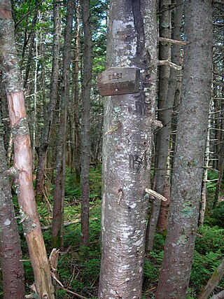
Wonalancet is an unincorporated community in the northwestern corner of the town of Tamworth in Carroll County, New Hampshire, United States. Many popular hiking trails into the Sandwich Range of the White Mountains have trailheads in the area, particularly in the locale known as Ferncroft, up a short spur road from Wonalancet.
The Sandwich Range is located in the White Mountains of New Hampshire in the United States, north of the Lakes Region and south of the Kancamagus Highway. Although the range is not outstanding for its elevation, it is very rugged and has excellent views of the surrounding lakes, mountains, and forests.

The Wonalancet River is a 7.6-mile-long (12.2 km) river in the White Mountains of New Hampshire in the United States. Named after the 17th-century Pennacook sachem Wonalancet, it is a tributary of the southern Swift River, part of the Bearcamp River / Ossipee Lake / Saco River watershed leading to the Atlantic Ocean.

Mount Passaconaway is a 4,043 ft (1,232 m) mountain in the Sandwich Range Wilderness of the White Mountain National Forest in Grafton County, New Hampshire, near Waterville Valley. It is named after Passaconaway, a 16th-century sachem of the Pennacook tribe, whose name was also attached to a small village in Albany, where the northern trailhead is now located.
Mount Whiteface is a 4,019 ft (1,225 m) mountain located in Grafton County, New Hampshire. The mountain is part of the Sandwich Range of the White Mountains. Whiteface is flanked to the northwest by Mount Tripyramid, and to the northeast by Mount Passaconaway. Whiteface is on the eastern border of the Sandwich Range Wilderness. To the east, between Whiteface, Passaconaway, and Mt. Wonalancet, lies The Bowl natural area, an unlogged cirque.

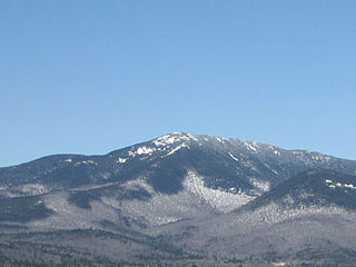
Mount Tripyramid is a mountain located in Grafton County, New Hampshire. Part of the Sandwich Range of the White Mountains, it has three distinct peaks – North, Middle, and South – along its mile-long summit ridge. North, at 4,160 ft (1,270 m), is the highest. Scaur Peak and The Fool Killer are subsidiary peaks to the northwest and northeast. To the southeast, Tripyramid is flanked by The Sleepers.

Sandwich Mountain is a 3,983 ft (1,214 m) mountain located on the border between Carroll and Grafton counties, New Hampshire spanning parts of the towns of Sandwich and Waterville Valley, respectively. The mountain is part of the Sandwich Range of the White Mountains.

Mount Doublehead is a twin-peaked mountain in eastern New Hampshire, United States. It is located in the town of Jackson, Carroll County, in the eastern White Mountains. North Doublehead has an elevation of 3,053 feet (930.5 m) above sea level, while South Doublehead has an elevation of 2,939 ft (895.8 m).
The Sleepers are two mountain peaks, East Sleeper 3,855 ft (1,175 m) and West Sleeper 3,881 ft (1,183 m), located within the Sandwich Range Wilderness in Grafton County, New Hampshire. Part of the Sandwich Range of the White Mountains, they are flanked to the northwest by Mount Tripyramid, to the northeast by Mount Passaconaway, and to the southeast by Mount Whiteface. The Kate Sleeper Trail passes close by both peaks.

Mount Major is a mountain located in Alton, New Hampshire, south of Lake Winnipesaukee and northeast of Straightback Mountain in the Belknap Range.
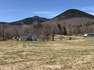
Ferncroft is an unincorporated community lying mostly in the town of Albany in Carroll County, New Hampshire, United States. Some of the roads and houses in Ferncroft stretch into the towns of Sandwich and Waterville Valley. The hamlet is a widely spaced cluster of houses centered on several fields lying along the Wonalancet River on Ferncroft Road.

The Belknap Mountains are a small mountain range in the Lakes Region of New Hampshire in the United States. The range lies in the towns of Gilford, Gilmanton, and Alton in Belknap County. The highest peak, Belknap Mountain, with an elevation of 2,382 feet (726 m) above sea level, is the highest point in Belknap County. Belknap Mountain State Forest covers the central part of the range, including the summit and slopes of Belknap Mountain.
