Presidential Range

Last updated
Presidential Range
Mtwashingtonautoroadsrsteel.jpg
The Presidential Range viewed from Pinkham Notch
Highest point
Peak Mount Washington
Elevation 6,288 ft (1,917 m)
Coordinates 44°16′14.98″N71°18′12.54″W / 44.2708278°N 71.3034833°W / 44.2708278; -71.3034833

44°19′42″N71°16′42″W / 44.32833°N 71.27833°W / 44.32833; -71.27833 (Mount Madison) 44°19′13.95″N71°17′29.71″W / 44.3205417°N 71.2915861°W / 44.3205417; -71.2915861 (Mount Adams) 44°18′15″N71°19′01″W / 44.30420°N 71.31685°W / 44.30420; -71.31685 (Mount Jefferson) 44°17.11′N71°18.95′W / 44.28517°N 71.31583°W / 44.28517; -71.31583 (Mount Clay) 44°16′14.98″N71°18′12.54″W / 44.2708278°N 71.3034833°W / 44.2708278; -71.3034833 (Mount Washington) 44°15′20″N71°19′21″W / 44.25556°N 71.3225°W / 44.25556; -71.3225 (Mount Monroe) 44°14.98′N71°19.82′W / 44.24967°N 71.33033°W / 44.24967; -71.33033 (Mount Franklin) 44°14.44′N71°21.02′W / 44.24067°N 71.35033°W / 44.24067; -71.35033 (Mount Eisenhower) 44°13.56′N71°21.96′W / 44.22600°N 71.36600°W / 44.22600; -71.36600 (Mount Pierce) 44°12.19′N71°22.53′W / 44.20317°N 71.37550°W / 44.20317; -71.37550 (Mount Jackson) 44°11.69′N71°23.29′W / 44.19483°N 71.38817°W / 44.19483; -71.38817 (Mount Webster)

Contents

44°19′54″N71°20′34″W / 44.33154°N 71.34270°W / 44.33154; -71.34270 (Mount Bowman) 44°16′47″N71°17′11″W / 44.27965°N 71.28638°W / 44.27965; -71.28638 (Nelson Crag) 44°15′10″N071°17′39″W / 44.25278°N 71.29417°W / 44.25278; -71.29417 (Boott Spur)

44°12.88′N71°18.58′W / 44.21467°N 71.30967°W / 44.21467; -71.30967 (Mount Isolation) 44°12′15″N71°18′38″W / 44.20417°N 71.31056°W / 44.20417; -71.31056 (Mount Davis) 44°09′21″N71°19′11″W / 44.15587°N 71.31978°W / 44.15587; -71.31978 (Stairs Mountain) 44°08′51″N71°18′50″W / 44.14753°N 71.31402°W / 44.14753; -71.31402 (Mount Resolution)

44°08′12″N71°19′57″W / 44.13665°N 71.33239°W / 44.13665; -71.33239 (Mount Crawford) 44°06′26″N71°20′04″W / 44.10725°N 71.33449°W / 44.10725; -71.33449 (Mount Hope) 44°07′25″N71°17′55″W / 44.12355°N 71.29856°W / 44.12355; -71.29856 (Mount Parker)

Naming
Etymology U.S. presidents
Geography
Country United States
State New Hampshire
Region New England
Parent range White Mountains
Map all coordinates using: OpenStreetMap
Computer-generated image from satellite data of the Presidential Range and vicinity on a rare clear day, 2014 Mt washington satfoto 2014.jpg
Computer-generated image from satellite data of the Presidential Range and vicinity on a rare clear day, 2014

The Presidential Range is a mountain range located in the White Mountains of the U.S. state of New Hampshire. Containing the highest peaks of the Whites, its most notable summits are named for American presidents, followed by prominent public figures of the 18th and 19th centuries. The Presidential Range is notorious for having some of the worst weather on Earth, mainly because of the unpredictability of high wind speeds and whiteout conditions on the higher summits. Because of the poor weather conditions, the Presidential Range is often used for mountaineering training for those who go on to climb some of the world's highest mountains, including K2 and Everest. [1] [2]

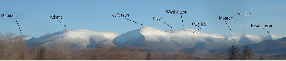
Mount Washington, long home of the highest winds recorded on the surface of the Earth at 231 mph (372 km/h), is the tallest at 6,288 ft (1,917 m), followed by neighboring peaks Mount Adams at 5,793 ft (1,766 m) and Mount Jefferson at 5,712 ft (1,741 m). The range is almost entirely in Coos County.

Notable summits

The highest mountains in the Presidential Range are named principally for U.S. presidents, with the tallest mountain (Mount Washington) named for the first president and the second tallest (Mount Adams) for the second president.

Among the range's most notable summits (in sequence from southwest to northeast):

Mount Adams has four subsidiary peaks besides its summit that are also commonly recognized by name. Two are listed above (Sam Adams and John Quincy Adams). The third and fourth are:

The summits marked with an asterisk (*) are included on the peak bagging list of 4,000-foot and higher mountains in New Hampshire; the others are excluded, in some cases because of lesser height and in others because of more technical criteria.

Presidential Range in winter (summits and Cog Railway labeled) NHpresidentials.JPG
Presidential Range in winter (summits and Cog Railway labeled)

Other summits

The Appalachian Trail in the southern Presidential Range SouthernPres.jpg
The Appalachian Trail in the southern Presidential Range

Aside from the notable summits, the Presidential Range contains a number of additional named peaks. Several of these peaks, drained on their west faces by the Dry River, are less accessible than the main and most-visited ridge of the range.

Subsidiary peaks of Mount Washington:

North from Mount Washington:

South from Mount Washington:

The summits marked with an asterisk (*) are included on the peak-bagging list of 4,000-foot and higher mountains in New Hampshire; the others are excluded, in some cases because of lesser height and in others because of more technical criteria.

Watersheds

The Presidentials separate drainage via the Saco and Androscoggin rivers into the Atlantic Ocean on the coast of Maine, from drainage into the Israel and Ammonoosuc rivers, thence into the Connecticut River, and thence into Long Island Sound.

Presidential Traverse

The so-called Presidential Traverse is a hike that traverses each major summit along the 19 miles (31 km) of the Presidential ridge. The traverse encompasses over 8,500 feet (2,600 m) in elevation gain. It can be done in a single day in summer, but during winter it is generally a two- to four-day venture. The traverse is considered strenuous. [4]

Hazards

Sign warning of weather. White Mountain National Forest Alpine Zone Warning Sign.jpg
Sign warning of weather.

The range is notorious for its unpredictable and inclement weather, with some of the deadliest mountains in the continental United States. Due to its unique location relative to other geographic features, it holds the world record for highest recorded surface wind speed not within a tropical cyclone. Fatalities in this area are dominated by those that occur on Mount Washington, the highest peak in the range. The New Hampshire Fish and Game Department conducts an average of 200 rescues a year for hikers in need of assistance. [5]

See also

Related Research Articles

<span class="mw-page-title-main">Thompson and Meserve's Purchase, New Hampshire</span> Township in Coos County, New Hampshire, United States

Thompson and Meserve's Purchase is a township in Coös County, New Hampshire, United States. The purchase lies entirely within the White Mountain National Forest. As of the 2020 census, the population of the purchase was 1.

<span class="mw-page-title-main">Mount Washington</span> Highest mountain in Northeastern United States

Mount Washington, in New Hampshire, is the highest peak in the Northeastern United States at 6,288.2 ft (1,916.6 m) and the most topographically prominent mountain east of the Mississippi River.

<span class="mw-page-title-main">White Mountains (New England)</span> Mountain range in New Hampshire and Maine, United States

The White Mountains are a mountain range covering about a quarter of the state of New Hampshire and a small portion of western Maine in the United States. They are a subrange of the northern Appalachian Mountains and the most rugged mountains in New England. Several of the higher peaks contain an Alpine tundra. The range is heavily visited due to its proximity to Boston, New York City, and Montreal.

<span class="mw-page-title-main">Mount Waddington</span> Mountain in British Columbia, Canada

Mount Waddington, once known as Mystery Mountain, is the highest peak in the Coast Mountains of British Columbia, Canada. Although it is lower than Mount Fairweather and Mount Quincy Adams, which straddle the United States border between Alaska and British Columbia, Mount Waddington is the highest peak that lies entirely within British Columbia. It and the subrange which surround it, known as the Waddington Range, stand at the heart of the Pacific Ranges, a remote and extremely rugged set of mountains and river valleys.

<span class="mw-page-title-main">Denali</span> Highest mountain in North America

Denali is the highest mountain peak in North America, with a summit elevation of 20,310 feet (6,190 m) above sea level. It is the tallest mountain in the world from base-to-peak on land, measuring 18,000 ft (5,500 m), and Earth's highest mountain north of 43°N. With a topographic prominence of 20,194 feet (6,155 m) and a topographic isolation of 4,621.1 miles (7,436.9 km), Denali is the third most prominent and third-most isolated peak on Earth, after Mount Everest and Aconcagua. Located in the Alaska Range in the interior of the U.S. state of Alaska, Denali is the centerpiece of Denali National Park and Preserve.

<span class="mw-page-title-main">Mount Adams (New Hampshire)</span> Mountain in New Hampshire, United States

Mount Adams, elevation 5,793 feet (1,766 m) above sea level, is a mountain in New Hampshire, the second highest peak in the Northeast United States after its nearby neighbor, Mount Washington. Located in the northern Presidential Range, Mount Adams was named after John Adams, the second President of the United States. It was given this name on July 31, 1820. To the northeast is Mount Madison and to the southwest is Mount Jefferson. From the summit, Mount Washington can be seen directly to the south.

<span class="mw-page-title-main">Mount Jefferson (New Hampshire)</span>

Mount Jefferson is located in Coos County, New Hampshire, and is the third highest mountain in the state. The mountain is named after Thomas Jefferson, the third president of the United States, and is part of the Presidential Range of the White Mountains. Mount Jefferson is flanked by Mount Adams and Mount Clay.

<span class="mw-page-title-main">Mount Madison</span> Mountain in New Hampshire, United States

Mount Madison is a 5,367-foot (1,636 m) mountain in the Presidential Range of New Hampshire in the United States. It is named after the fourth U.S. President, James Madison.

Four-thousand footers are a group of forty-eight mountains in New Hampshire at least 4,000 feet (1,200 m) above sea level. To qualify for inclusion a peak must also meet the more technical criterion of topographic prominence important in the mountaineering sport of peak-bagging.

<span class="mw-page-title-main">Mount Lafayette</span> Mountain in New Hampshire, United States

Mount Lafayette is a 5,249-foot (1,600 m) mountain at the northern end of the Franconia Range in the White Mountains of New Hampshire, United States. It lies in the town of Franconia in Grafton County, and appears on the New England Fifty Finest list of the most topographically prominent peaks in New England. The mountain's upper reaches are located in the alpine zone, an area where only dwarf vegetation exists due to the harsh climate.

<span class="mw-page-title-main">Mount Monroe</span> Mountain in the American state of New Hampshire

Mount Monroe is a 5,372-foot-high (1,637 m) mountain peak southwest of Mount Washington in the Presidential Range of the White Mountains in New Hampshire, United States. It is named for American President James Monroe and is the fourth highest mountain on the 4000 footers list for New Hampshire. The Appalachian Trail skirts its summit, which is the next highest peak on or near the trail north of Mount Rogers in Virginia. The Lakes of the Clouds, and its AMC hut, lie nestled at the col between Mount Monroe and neighboring Mount Washington.

<span class="mw-page-title-main">Mount Clay</span>

Mount Clay is a peak located in Thompson and Meserve's Purchase in Coos County in the Presidential Range of the White Mountains of New Hampshire. It is a rise about 0.9-mile (1.4 km) long and a few hundred feet tall, with summit elevation of 5,533 feet (1,686 m); it lies on the ridge joining the summits of Mount Washington, about 0.9-mile (1.4 km) to the south-southeast, with that of Mount Jefferson, about 1.3-mile (2.1 km) north.

<span class="mw-page-title-main">Mount Pierce (New Hampshire)</span> Mountain in New Hampshire, U.S.

Mount Pierce is a mountain in the Presidential Range in the White Mountains of New Hampshire that is approximately 4,310 feet (1,310 m) high. Formerly called Mount Clinton for 19th-century governor DeWitt Clinton of New York, in 1913 it was renamed after President Franklin Pierce (1804–1869), the only president born in New Hampshire, although it was several decades before the name was widely recognized. Its summit offers a wide view of New Hampshire's mountains.

The Appalachian National Scenic Trail spans 14 U.S. states over its roughly 2,200 miles (3,500 km): Georgia, North Carolina, Tennessee, Virginia, West Virginia, Maryland, Pennsylvania, New Jersey, New York, Connecticut, Massachusetts, Vermont, New Hampshire, and Maine. The southern end is at Springer Mountain, Georgia, and it follows the ridgeline of the Appalachian Mountains, crossing many of its highest peaks and running almost continuously through wilderness before reaching the northern end at Mount Katahdin, Maine.

<span class="mw-page-title-main">Mount Willey</span> Mountain in the state of New Hampshire

Mount Willey is a mountain located in Grafton County, New Hampshire. The mountain is named after Samuel Willey, Jr. (1766–1826) and his family, who in 1825 moved into a house in Crawford Notch. The family was killed a year later in August 1826 during a landslide.

<span class="mw-page-title-main">Mount Tripyramid (New Hampshire)</span> Mountain in the state of New Hampshire

Mount Tripyramid is a mountain located in Grafton County, New Hampshire. Part of the Sandwich Range of the White Mountains, it has three distinct peaks – North, Middle, and South – along its mile-long summit ridge. North, at 4,160 ft (1,270 m), is the highest. Scaur Peak and The Fool Killer are subsidiary peaks to the northwest and northeast. To the southeast, Tripyramid is flanked by The Sleepers.

<span class="mw-page-title-main">Franconia Range</span>

The Franconia Range is a mountain range located in the White Mountains of the U.S. state of New Hampshire. It is the second-highest range of peaks in the White Mountains.

The Presidential Traverse is a strenuous and sometimes dangerous trek over the Presidential Range of New Hampshire's White Mountains. Contained almost entirely in the 750,000-acre (3,000 km2) White Mountain National Forest, the Presidential Range is a string of summits in excess of 4,000 feet (1,200 m). To complete the traverse, one must begin at either the northern or southern terminus of the Presidential Range and finish at the opposing end. Beginning the journey at the northern end at Mount Madison, one would pass through the townships of Low and Burbank's Grant, Thompson and Meserve's Purchase, Sargent's Purchase, Chandler's Purchase, and Bean's Grant, all of which are in Coös County.

<span class="mw-page-title-main">Jules Eichorn</span>

Jules Marquard Eichorn was an American mountaineer, environmentalist, and music teacher.

References

  1. "Mt Washington Mountaineering".
  2. "Preparing for a Winter Mt Washington Climb | Northeast Mountaineering".
  3. Condensed Facts About Mount Washington, Atkinson News Co. (1912)
  4. "Presidential Traverse FAQ". Peakbagging the 4000 Footer Mountains of New England. Archived from the original on December 2, 2008. Retrieved October 23, 2013.
  5. "As Hikers Flock To The White Mountains, Search And Rescue Missions Are On The Rise". WBUR. 2019-10-13. Retrieved 2019-10-19.