
Moultonborough is a town in Carroll County, New Hampshire, United States. The population was 4,918 at the 2020 census, up from 4,044 at the 2010 census. Moultonborough is bounded in large part by Lake Winnipesaukee in the southwest and to a lesser extent by Squam Lake in the northwest corner. The town includes the census-designated place of Suissevale and the community of Lees Mill.

Mount Washington, in New Hampshire, is the highest peak in the Northeastern United States at 6,288.2 ft (1,916.6 m) and the most topographically prominent mountain east of the Mississippi River.

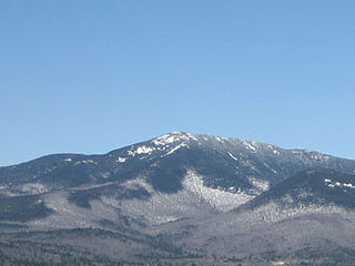
Mount Jefferson is located in Coos County, New Hampshire, and is the third highest mountain in the state. The mountain is named after Thomas Jefferson, the third president of the United States, and is part of the Presidential Range of the White Mountains. Mount Jefferson is flanked by Mount Adams and Mount Clay.
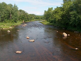
The Israel River, sometimes referred to as Israel's River, is a 23.2-mile-long (37.3 km) river in the White Mountains of New Hampshire, in the United States. It rises in the township of Low and Burbank's Grant and runs generally northwest along U.S. Route 2, traversing the towns of Jefferson and Lancaster, before joining the Connecticut River.
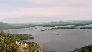
The Lakes Region of New Hampshire is located in the east-central part of the state, south of the White Mountains Region and extending to the Maine border. It is named for the numerous lakes in the region, the largest of which are Lake Winnipesaukee, Lake Winnisquam, Squam Lake, and Newfound Lake. The area comprises all of Belknap County, the southern portion of Carroll County, the eastern portion of Grafton County, and the northern portions of Strafford County and Merrimack County. The largest municipality is the city of Laconia.

Mount Chocorua is a 3,490 ft (1,060 m) mountain in the White Mountains of New Hampshire, the easternmost peak of the Sandwich Range. Although the mountain is not outstanding for its elevation, it is very rugged and has excellent views of the surrounding lakes, mountains, and forests. Being at the end of the range, its bare summit can be seen from almost every direction and identified from many points throughout central New Hampshire and western Maine, and it has been the subject of numerous works of art. Many hiking trails ascend the mountain. Scenic Chocorua Lake lies directly to the south.

Castle in the Clouds is a 16-room mansion and 5,294-acre (2,142 ha) mountaintop estate in Moultonborough, New Hampshire, opened seasonally to the public by the Castle Preservation Society. It overlooks Lake Winnipesaukee and the Ossipee Mountains from a rocky outcropping of Lee Mountain formerly known as "The Crow's Nest".

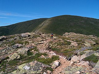
Mount Shaw is a mountain located in the towns of Moultonborough and Tuftonboro in Carroll County, New Hampshire, United States. It is part of the remains of an ancient volcanic ring dike. With a summit elevation of 2,990 feet (911 m), it is the highest of the Ossipee Mountains.

Mount Field is a mountain located in Grafton County, New Hampshire. The mountain is named after Darby Field (1610–1649), who in 1642 made the first known ascent of Mount Washington. Mount Field is the highest peak of the Willey Range of the White Mountains. Mt. Field is flanked to the northwest by Mount Tom, and to the southwest by Mount Willey.

Mount Willey is a mountain located in Grafton County, New Hampshire. The mountain is named after Samuel Willey, Jr. (1766–1826) and his family, who in 1825 moved into a house in Crawford Notch. The family was killed a year later in August 1826 during a landslide.

Mount Tom is a mountain located in Grafton County, New Hampshire, about 1.5 miles (2.4 km) southwest of the height of land of Crawford Notch.
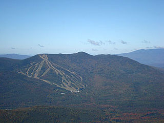
Mount Tecumseh is a mountain located in Grafton County, New Hampshire. The mountain is named after the Shawnee leader Tecumseh, and is a part of the White Mountains. The east side of Tecumseh drains into the Mad River; the west side drains into several brooks. All are tributaries of the Pemigewasset River, which drains into the Merrimack River and thence into the Gulf of Maine in Massachusetts.
Mount Whiteface is a 4,019 ft (1,225 m) mountain located in Grafton County, New Hampshire. The mountain is part of the Sandwich Range of the White Mountains. Whiteface is flanked to the northwest by Mount Tripyramid, and to the northeast by Mount Passaconaway. Whiteface is on the eastern border of the Sandwich Range Wilderness. To the east, between Whiteface, Passaconaway, and Mt. Wonalancet, lies The Bowl natural area, an unlogged cirque.

Mount Tripyramid is a mountain located in Grafton County, New Hampshire. Part of the Sandwich Range of the White Mountains, it has three distinct peaks – North, Middle, and South – along its mile-long summit ridge. North, at 4,160 ft (1,270 m), is the highest. Scaur Peak and The Fool Killer are subsidiary peaks to the northwest and northeast. To the southeast, Tripyramid is flanked by The Sleepers.
Mount Bond is a mountain located in Grafton County, New Hampshire, United States. The mountain is named after Professor George P. Bond (1825–1865) of Harvard University, and is the southernmost extension of the Twin Range of the White Mountains. Mount Bond is flanked to the north by Mount Guyot.
Mount Weeks, formerly Round Mountain, is a mountain located in Coos County, New Hampshire. Mt. Weeks is the northeasternmost of the Pliny Range of the White Mountains and the highest point within the city limits of Berlin, New Hampshire. Mount Weeks is flanked to the southwest by South Weeks, and faces Terrace Mountain to the northwest across Willard Notch.

Mount Rowe, elevation 1,680 feet (510 m), is a mountain located north of Gunstock Mountain in the Belknap Range, Belknap County, New Hampshire, United States. It has been home to multiple alpine ski operations, including the original Gunstock Mountain Resort single chairlift, the Belknap Ski Jumps, and the defunct Alpine Ridge/Mt. Rowe ski area.
The Ossipee Mountains are a small mountain range in the New England state of New Hampshire, United States. The remains of an ancient volcanic ring dike, they lie north of Lake Winnipesaukee, east of Squam Lake, and south of the Sandwich Range, the southernmost of the White Mountains. 2,990 ft (910 m) Mount Shaw is their highest point.
Larcom Mountain is a mountain located in Carroll County, New Hampshire, USA. The top of the mountain, and its subpeak, Little Larcom Mountain, are part of the Lakes Region Conservation Trust.

The Crawford Path is an 8.5-mile-long (13.7 km) hiking trail in the White Mountains of New Hampshire that is considered to be the United States' oldest continuously maintained hiking trail. It travels from Crawford Notch to the summit of Mount Washington (Agiocochook). The first iteration of the Crawford Path was cut in 1819 by Ethan Allen Crawford and his father, Abel Crawford. The trail ascends a cumulative 4,900 feet (1,500 m), first through densely wooded forest for about 3.1 miles (5.0 km), then following the exposed southern ridge of the Presidential Range mostly above the treeline.
