Mount Crescent is a mountain located in the Crescent Range of the White Mountains in Randolph, New Hampshire. It is 3,251 ft (991 m) high, and its summit is the second highest mountain summit in Randolph, after Black Crescent Mountain. Both mountains are in Randolph's Ice Gulch Town Forest. On the 1896 topographic map, Mount Crescent is shown as "Randolph Mtn." with an elevation of 3,280 ft, and Black Crescent is shown as "Mt. Crescent" with an elevation of 3,322 ft.
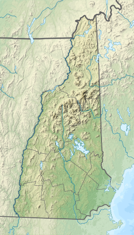
Mount Lincoln is a 5,089-foot-high (1,551 m) mountain within the Franconia Range of the White Mountains of New Hampshire. Lincoln is located between Little Haystack and Mount Lafayette. All three overlook Franconia Notch. The west side of Lincoln drains into the main stem of the Pemigewasset River. The east side drains into Lincoln Brook, thence into the Franconia Branch of the Pemigewasset.

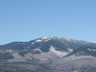
Mount Carrigain is a mountain located in Grafton County, New Hampshire. The mountain is named after Phillip Carrigain, NH Secretary of State (1805–10), and is on the south side of the Pemigewasset Wilderness, the source of the East Branch of the Pemigewasset River in the heart of the White Mountains, between Franconia Notch and Crawford Notch. Carrigain is flanked to the northeast beyond Carrigain's Vose Spur by Mount Anderson and Mount Lowell across Carrigain Notch, and to the southwest by Mount Hancock. It has a fire tower at the summit, providing 360 degree views of the surrounding wilderness.

Mount Shaw is a mountain located in the towns of Moultonborough and Tuftonboro in Carroll County, New Hampshire, United States. It is part of the remains of an ancient volcanic ring dike. With a summit elevation of 2,990 feet (911 m), it is the highest of the Ossipee Mountains.

The Sandwich Range is located in the White Mountains of New Hampshire in the United States, north of the Lakes Region and south of the Kancamagus Highway. Although the range is not outstanding for its elevation, it is very rugged and has excellent views of the surrounding lakes, mountains, and forests.
Mount Franklin is a mountain in Coös County, New Hampshire, United States. The mountain is named after Benjamin Franklin and is part of the Presidential Range of the White Mountains. Note that Ben Franklin was not a president. Mount Franklin is flanked to the northeast by Mount Monroe, and to the southwest by Mount Eisenhower.

Mount Field is a mountain located in Grafton County, New Hampshire. The mountain is named after Darby Field (1610–1649), who in 1642 made the first known ascent of Mount Washington. Mount Field is the highest peak of the Willey Range of the White Mountains. Mt. Field is flanked to the northwest by Mount Tom, and to the southwest by Mount Willey.

Mount Willey is a mountain located in Grafton County, New Hampshire. The mountain is named after Samuel Willey, Jr. (1766–1826) and his family, who in 1825 moved into a house in Crawford Notch. The family was killed a year later in August 1826 during a landslide.

Mount Garfield is a mountain located in Grafton County, New Hampshire. The mountain is part of the White Mountains. Mt. Garfield is flanked to the east by South Twin Mountain, and to the southwest along Garfield Ridge by Mount Lafayette.
Mount Tecumseh is a mountain located in Grafton County, New Hampshire. The mountain is named after the Shawnee leader Tecumseh, and is a part of the White Mountains. The east side of Tecumseh drains into the Mad River; the west side drains into several brooks. All are tributaries of the Pemigewasset River, which drains into the Merrimack River and thence into the Gulf of Maine in Massachusetts.
Mount Whiteface is a 4,019 ft (1,225 m) mountain located in Grafton County, New Hampshire. The mountain is part of the Sandwich Range of the White Mountains. Whiteface is flanked to the northwest by Mount Tripyramid, and to the northeast by Mount Passaconaway. Whiteface is on the eastern border of the Sandwich Range Wilderness. To the east, between Whiteface, Passaconaway, and Mt. Wonalancet, lies The Bowl natural area, an unlogged cirque.

Mount Tripyramid is a mountain located in Grafton County, New Hampshire. Part of the Sandwich Range of the White Mountains, it has three distinct peaks – North, Middle, and South – along its mile-long summit ridge. North, at 4,160 ft (1,270 m), is the highest. Scaur Peak and The Fool Killer are subsidiary peaks to the northwest and northeast. To the southeast, Tripyramid is flanked by The Sleepers.

Kinsman Mountain is a mountain located in Grafton County, New Hampshire. It is named after Nathan Kinsman, an early resident of Easton, New Hampshire, and is part of the Kinsman Range of the White Mountains. To the northeast, Kinsman is connected by The Cannon Balls ridge to Cannon Mountain.
Mount Guyot is a mountain located in Grafton County, New Hampshire. The mountain is named after Professor Arnold H. Guyot (1807–1884) of Princeton University, and is part of the Twin Range of the White Mountains. Mount Guyot is flanked to the northwest by South Twin Mountain, to the northeast by Mount Zealand, and to the south by Mount Bond. Guyot is on the northern boundary of the Pemigewasset Wilderness. The immediate area around the summit consists of high-altitude spruce-fir forest or krummholz.

Sandwich Mountain is a 3,983 ft (1,214 m) mountain located on the border between Carroll and Grafton counties, New Hampshire spanning parts of the towns of Sandwich and Waterville Valley, respectively. The mountain is part of the Sandwich Range of the White Mountains.

Mount Webster is a mountain located on the border between Coos County and Carroll County, New Hampshire. The mountain, formerly called Notch Mountain, is named after Daniel Webster (1782–1852), and is the south-westernmost of the Presidential Range of the White Mountains. Mount Webster is flanked to the northeast by Mount Jackson; to the southwest it faces Mount Willey across Crawford Notch.

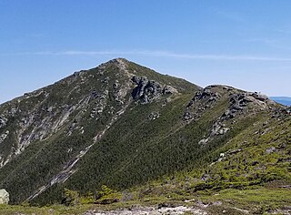
The Pemigewasset Wilderness is a 45,000-acre (182 km2) federally designated Wilderness Area in the heart of New Hampshire's White Mountains. It is a part of the White Mountain National Forest. It is New Hampshire's largest wilderness area.

The Sleepers are two mountain peaks, East Sleeper 3,855 ft (1,175 m) and West Sleeper 3,881 ft (1,183 m), located within the Sandwich Range Wilderness in Grafton County, New Hampshire. Part of the Sandwich Range of the White Mountains, they are flanked to the northwest by Mount Tripyramid, to the northeast by Mount Passaconaway, and to the southeast by Mount Whiteface. The Kate Sleeper Trail passes close by both peaks.
Scar Ridge, also known as Scar Ridge , is a mountain located in Grafton County, New Hampshire. It is part of the White Mountains. It is officially trailless and several different routes are possible. Scar Ridge is flanked to the west by Loon Mountain, to the northwest by Black Mountain, and to the east by Mount Osceola.

Bartlett Haystack is a mountain located in Bartlett, New Hampshire. Like the town, the mountain is named after Josiah Bartlett (1729–1795), one of the signers of the Declaration of Independence and sixth Governor of New Hampshire. Bartlett Haystack is flanked to the west by Mount Tremont, and to the southeast across Bear Notch by Bear Mountain.