| Shelburne Moriah Mountain | |
|---|---|
| Highest point | |
| Elevation | 1,138 m (3,734 ft) |
| Prominence | 136 m (446 ft) |
| Coordinates | 44°21′10″N071°05′55″W / 44.35278°N 71.09861°W |
| Geography | |
| Location | Coös County, New Hampshire, U.S. |
| Parent range | Carter-Moriah Range |
| Topo map | USGS Wild River |
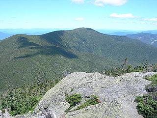
Shelburne Moriah Mountain is a mountain located in Coos County, New Hampshire. The mountain is part of the Carter-Moriah Range of the White Mountains, which runs along the northern east side of Pinkham Notch. Shelburne Moriah is flanked to the southwest by Middle Moriah Mountain. It is the northernmost Moriah Range summit along the Appalachian Trail, which crosses the Androscoggin River at Shelburne, New Hampshire, and continues north into the Mahoosuc Range.
| | This New Hampshire state location article is a stub. You can help Wikipedia by expanding it. |

Shelburne is a town in Coös County, New Hampshire, United States. The population was 353 at the 2020 census. It is located in the White Mountains, and part of the White Mountain National Forest is in the south. Shelburne is home to Leadmine State Forest. The Appalachian Trail crosses the town.

The White Mountains are a mountain range covering about a quarter of the state of New Hampshire and a small portion of western Maine in the United States. They are a subrange of the northern Appalachian Mountains and the most rugged mountains in New England. Several of the higher peaks contain an Alpine tundra. The range is heavily visited due to its proximity to Boston, New York City, and Montreal.

Bean's Purchase is a township in Coös County, New Hampshire, United States. The purchase lies entirely within the White Mountain National Forest. The population was zero as of the 2020 census.

The White Mountain National Forest (WMNF) is a federally managed forest contained within the White Mountains in the northeastern United States. It was established in 1918 as a result of the Weeks Act of 1911; federal acquisition of land had already begun in 1914. It has a total area of 750,852 acres (303,859 ha). Most of the WMNF is in New Hampshire; a small part is in the neighboring state of Maine. Conservationist and community activist Katherine Sleeper Walden was instrumental in securing at-risk land for the forest, including thousands of acres in the region surrounding the locally famous Bowl near Wonalancet.
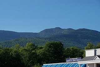
Carter Dome, or simply The Dome, is a mountain located in Coös County, New Hampshire, U.S. It has a maximum elevation of 4,826 feet (1,471 m), placing it on the list of the state's four-thousand footers.

The Peabody River is a 12.9-mile-long (20.8 km) river in the White Mountains of New Hampshire in the United States. It is a tributary of the Androscoggin River, which flows south and east into Maine, joining the Kennebec River near the Atlantic Ocean.

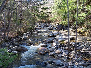
The Wild River is a 17.2-mile-long (27.7 km) river in the White Mountains of New Hampshire and Maine in the United States. It is a tributary of the Androscoggin River, which flows east and south to the Kennebec River near the Atlantic Ocean.
The Mahoosuc Range, a northern extension of the White Mountains, straddles the border between New Hampshire and Maine. The range's highest peak, 4,170-foot (1,270 m) Old Speck Mountain, is the fifth-highest peak in Maine. Substantial parts of the range are publicly owned as parts of the National Park Service Appalachian Trail corridor and Grafton Notch State Park in Maine. The range is a subrange of the Appalachian Mountains.

Mount Hight is a mountain located in Coos County, New Hampshire. The mountain is part of the Carter-Moriah Range of the White Mountains, which runs along the eastern-northeastern side of Pinkham Notch. Mount Hight is flanked on the north by South Carter Mountain across Zeta Pass, and on the southwest by Carter Dome.

South Carter Mountain is a mountain located in Coos County, New Hampshire. The mountain is part of the Carter-Moriah Range of the White Mountains, which runs along the northern east side of Pinkham Notch. South Carter is flanked to the northeast by Middle Carter Mountain and to the southeast Mount Hight.
Middle Carter Mountain is a mountain located in Coos County, New Hampshire. The mountain is part of the Carter-Moriah Range of the White Mountains, which runs along the northern east side of Pinkham Notch. Middle Carter is flanked to the north by North Carter Mountain and to the southwest by South Carter Mountain. The summit of Middle Carter is wooded, but there are views from the ridgecrest not far from the summit.

North Carter Mountain is a mountain located in Coos County, New Hampshire. The mountain is part of the Carter-Moriah Range of the White Mountains, which runs along the northern east side of Pinkham Notch. North Carter is flanked to the northeast by Imp Mountain, and to the southwest by Middle Carter Mountain.

Imp Mountain is a mountain located in Coos County, New Hampshire. The mountain is part of the Carter-Moriah Range of the White Mountains, which runs along the northern east side of Pinkham Notch. Imp Mountain is flanked to the northeast by Mount Moriah, and to the southwest by North Carter Mountain.
Mount Moriah is a mountain located in Coos County, New Hampshire. The mountain is part of the Carter-Moriah Range of the White Mountains, which runs along the northern east side of Pinkham Notch. The summit is approximately 5 miles (8 km) southeast of the center of the town of Gorham. Mount Moriah is flanked to the northeast by Middle Moriah Mountain and to the southwest by Imp Mountain. The summit is located on the Appalachian Trail and affords views in all directions.
Middle Moriah Mountain is a mountain located in Coos County, New Hampshire. The mountain is part of the Carter-Moriah Range of the White Mountains, which runs along the northern east side of Pinkham Notch. Middle Moriah is flanked to the northeast by Shelburne Moriah Mountain, and to the southwest by Mount Moriah.
The Carter-Moriah Range of mountains is located in the White Mountains, in Coös County, New Hampshire. The range forms the northern east side of Pinkham Notch, opposite the northern Presidential Range. The range is also referred to as the Carter Range.
Moriah is the name given to a mountainous region in the Book of Genesis.
The Rattle River is a 4.1-mile-long (6.6 km) river in the White Mountains of New Hampshire in the United States. It is a tributary of the Androscoggin River, which flows east into Maine, joining the Kennebec River close to the Atlantic Ocean.

U.S. Route 2 (US 2) is a part of the United States Numbered Highway System that is split into two segments, one between Washington and Michigan and the other between New York and Maine. In New Hampshire, US 2 runs 35.437 miles (57.030 km) from the Vermont state line at the Connecticut River in Lancaster east to the Maine state line in Shelburne. US 2 is the main highway through the White Mountains across southern Coös County, where it also passes through Jefferson, Randolph, and Gorham. US 2 is the main connection between the Coös county seat of Lancaster, where the highway intersects US 3, and the county's largest city, Berlin, via its connection with New Hampshire Route 16 (NH 16) in Gorham.

North Baldface is a 3,606-foot (1,099 m) mountain in the township of Bean's Purchase, New Hampshire in the eastern White Mountains. It gets its name from its steep barren southeast face. Along with the neighboring summit South Baldface, it is a popular hiking destination, especially in the summer. The two mountains are ascended by the Slippery Brook, Baldface Knob, Baldface Circle, Meader Ridge, and Bicknell Ridge trails.