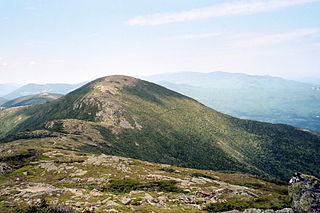
Mount Eisenhower, formerly Mount Pleasant, is a mountain in the Presidential Range in the White Mountains of New Hampshire approximately 4,757 feet (1,450 m) high. Named after President Dwight D. Eisenhower, its summit offers a 360° view. It is inaccessible by road.
The Four-thousand footers are a group of forty-eight mountains in New Hampshire at least 4,000 feet (1,200 m) above sea level. To qualify for inclusion a peak must also meet the more technical criterion of topographic prominence important in the mountaineering sport of peak-bagging.

Carter Dome, or simply The Dome, is a mountain located in Coös County, New Hampshire, U.S. It has a maximum elevation of 4,826 feet (1,471 m), placing it on the list of the state's four-thousand footers.

Mount Moosilauke is a 4,802-foot-high (1,464 m) mountain at the southwestern end of the White Mountains in the town of Benton, New Hampshire, United States. It is the tenth highest and most southwesterly of the 4,000 foot summits in the White Mountains.

Mount Monroe is a 5,372-foot-high (1,637 m) mountain peak southwest of Mount Washington in the Presidential Range of the White Mountains in New Hampshire, United States. It is named for American President James Monroe and is the fourth highest mountain on the 4000 footers list for New Hampshire. The Appalachian Trail skirts its summit, which is the next highest peak on or near the trail north of Mount Rogers in Virginia. The Lakes of the Clouds, and its AMC hut, lie nestled at the col between Mount Monroe and neighboring Mount Washington.
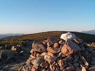
The East Peak of Mount Osceola is one of the official New Hampshire 4000-footers, standing at an elevation of 4,156 feet (1,267 m). East Osceola's prominence is between 316 feet (96 m) and 356 feet (109 m), with the key saddle between it and Mount Osceola. It can be approached via the Greeley Ponds trail from the Kancamagus Highway or from the summit of neighboring Osceola. Both routes are not without difficulties; the trail from the ponds is extremely steep and prolonged, and the approach from Osceola contains a chimney, along with a less hazardous bypass by way of the saddle connecting the peaks. The summit is nondescript and surrounded by trees.

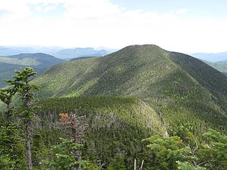
Mount Hight is a mountain located in Coos County, New Hampshire. The mountain is part of the Carter-Moriah Range of the White Mountains, which runs along the eastern-northeastern side of Pinkham Notch. Mount Hight is flanked on the north by South Carter Mountain across Zeta Pass, and on the southwest by Carter Dome.

South Carter Mountain is a mountain located in Coos County, New Hampshire. The mountain is part of the Carter-Moriah Range of the White Mountains, which runs along the northern east side of Pinkham Notch. South Carter is flanked to the northeast by Middle Carter Mountain and to the southeast Mount Hight.
Middle Carter Mountain is a mountain located in Coos County, New Hampshire. The mountain is part of the Carter-Moriah Range of the White Mountains, which runs along the northern east side of Pinkham Notch. Middle Carter is flanked to the north by North Carter Mountain and to the southwest by South Carter Mountain. The summit of Middle Carter is wooded, but there are views from the ridgecrest not far from the summit.

Wildcat Mountain is a mountain located in Coos County, northern New Hampshire, United States. The mountain is part of the Carter-Moriah Range of the White Mountains, on the east side of Pinkham Notch. Wildcat Mountain faces Carter Dome across Carter Notch to the northeast, and Mount Washington across Pinkham Notch to the west.

Mount Hancock is a mountain in Grafton County, New Hampshire, named after John Hancock (1737–1793), one of the Founding Fathers of the United States.
The Carter-Moriah Range of mountains is located in the White Mountains, in Coös County, New Hampshire. The range forms the northern east side of Pinkham Notch, opposite the northern Presidential Range. The range is also referred to as the Carter Range.

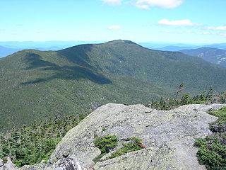
Mount Passaconaway is a 4,043 ft (1,232 m) mountain in the Sandwich Range Wilderness of the White Mountain National Forest in Grafton County, New Hampshire, near Waterville Valley. It is named after Passaconaway, a 16th-century sachem of the Pennacook tribe, whose name was also attached to a small village in Albany, where the northern trailhead is now located.

Little Haystack Mountain is a peak on the Franconia Range of the White Mountains located in Grafton County, New Hampshire, United States. It is flanked to the north by Mount Lincoln and to the southwest by Mount Liberty.

Mount Tripyramid is a mountain located in Grafton County, New Hampshire. Part of the Sandwich Range of the White Mountains, it has three distinct peaks – North, Middle, and South – along its mile-long summit ridge. North, at 4,160 ft (1,270 m), is the highest. Scaur Peak and The Fool Killer are subsidiary peaks to the northwest and northeast. To the southeast, Tripyramid is flanked by The Sleepers.
Mount Guyot is a mountain located in Grafton County, New Hampshire. The mountain is named after Professor Arnold H. Guyot (1807–1884) of Princeton University, and is part of the Twin Range of the White Mountains. Mount Guyot is flanked to the northwest by South Twin Mountain, to the northeast by Mount Zealand, and to the south by Mount Bond. Guyot is on the northern boundary of the Pemigewasset Wilderness. The immediate area around the summit consists of high-altitude spruce-fir forest or krummholz.
The Franconia Range is a mountain range located in the White Mountains of the U.S. state of New Hampshire. It is the second-highest range of peaks in the White Mountains.
The Pilot Range is located in the White Mountains of New Hampshire in the United States. The Pilot Range extends southeast–northwest about 15 miles (24 km). The highest peak in the range is Mount Cabot, with an elevation of 4,160 feet (1,270 m).

