
The Battle of Bennington was a battle of the American Revolutionary War, part of the Saratoga campaign, that took place on August 16, 1777, in Walloomsac, New York, about 10 miles (16 km) from its namesake, Bennington, Vermont. A rebel force of 2,000 men, primarily New Hampshire and Massachusetts militiamen, led by General John Stark, and reinforced by Vermont militiamen led by Colonel Seth Warner and members of the Green Mountain Boys, decisively defeated a detachment of General John Burgoyne's army led by Lieutenant Colonel Friedrich Baum, and supported by additional men under Lieutenant Colonel Heinrich von Breymann.
Sandwich is a town in Carroll County, New Hampshire, United States. Its population was 1,466 at the 2020 census. Sandwich includes the villages of Center Sandwich and North Sandwich. Part of the White Mountain National Forest is in the north, and part of Squam Lake is in the southwestern corner of the town. As such, Sandwich lies on the boundary between New Hampshire's Lakes Region and White Mountains Region. The Sandwich Range of the White Mountains lies partially within the town, as does the namesake Sandwich Mountain. The town is home to the Sandwich Fair, a popular agricultural fair that occurs every October.

Tamworth is a town in Carroll County, New Hampshire, United States. The population was 2,812 at the 2020 census. Tamworth includes the villages of Chocorua, South Tamworth, Wonalancet, and Whittier. The White Mountain National Forest is to the north. The town is home to Hemenway State Forest in the north and White Lake State Park in the southeast.
The White Mountains are a mountain range covering about a quarter of the state of New Hampshire and a small portion of western Maine in the United States. They are part of the northern Appalachian Mountains and the most rugged mountains in New England. The range is heavily visited due to its proximity to Boston, New York City, and Montreal.

Mount Monadnock, or Grand Monadnock, is a mountain in the towns of Jaffrey and Dublin, New Hampshire. It is the most prominent mountain peak in southern New Hampshire and is the highest point in Cheshire County. It lies 38 miles (61 km) southwest of Concord and 62 miles (100 km) northwest of Boston. At 3,165 feet (965 m), Mount Monadnock is nearly 1,000 feet (305 m) higher than any other mountain peak within 30 miles (48 km) and rises 2,000 feet (610 m) above the surrounding landscape. Monadnock's bare, isolated, and rocky summit provides expansive views. It is known for being featured in the writings of Ralph Waldo Emerson and Henry David Thoreau.

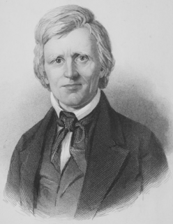
John Greenleaf Whittier was an American Quaker poet and advocate of the abolition of slavery in the United States. Frequently listed as one of the fireside poets, he was influenced by the Scottish poet Robert Burns. Whittier is remembered particularly for his anti-slavery writings, as well as his 1866 book Snow-Bound.
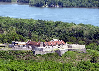
The 1777 Siege of Fort Ticonderoga occurred between the 2nd and 6 July 1777 at Fort Ticonderoga, near the southern end of Lake Champlain in the state of New York. Lieutenant General John Burgoyne's 8,000-man army occupied high ground above the fort, and nearly surrounded the defenses. These movements precipitated the occupying Continental Army, an under-strength force of 3,000 under the command of General Arthur St. Clair, to withdraw from Ticonderoga and the surrounding defenses. Some gunfire was exchanged, and there were some casualties, but there was no formal siege and no pitched battle. Burgoyne's army occupied Fort Ticonderoga and Mount Independence, the extensive fortifications on the Vermont side of the lake, without opposition on 6 July. Advance units pursued the retreating Americans.
New Hampshire Route 25 is a 96.62-mile (155.49 km) long east–west state highway in New Hampshire. It runs completely across the state from Vermont to Maine.

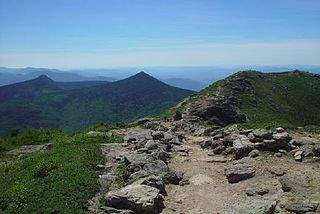
Mount Chocorua is a 3,490 ft (1,060 m) mountain in the White Mountains of New Hampshire, the easternmost peak of the Sandwich Range. Although the mountain is not outstanding for its elevation, it is very rugged and has excellent views of the surrounding lakes, mountains, and forests. Being at the end of the range, its bare summit can be seen from almost every direction and identified from many points throughout central New Hampshire and western Maine, and it has been the subject of numerous works of art. Many hiking trails ascend the mountain. Scenic Chocorua Lake lies directly to the south.

The Bearcamp River is a 26.3-mile-long (42.3 km) river at the southern edge of the White Mountains in New Hampshire, the United States. It is the largest tributary of Ossipee Lake, part of the Saco River watershed leading to the Atlantic Ocean.
The Swift River is an 8.3-mile-long (13.4 km) river located in eastern New Hampshire in the United States. It is a tributary of the Bearcamp River, part of the Ossipee Lake / Saco River watershed leading to the Atlantic Ocean. The Swift River is located only four miles south of the larger and longer Swift River which parallels the Kancamagus Highway in the White Mountain National Forest.
Mill Brook is a 10.7-mile-long (17.2 km) stream in the White Mountains of New Hampshire in the United States. It is a tributary of the southern Swift River, part of the Bearcamp River / Ossipee Lake / Saco River watershed leading to the Atlantic Ocean.
Nathaniel Peabody Rogers was an American attorney turned abolitionist writer, who served, from June 1838 until June 1846, as editor of the New England anti-slavery newspaper Herald of Freedom.

Mount Major is a mountain located in Alton, New Hampshire, south of Lake Winnipesaukee and northeast of Straightback Mountain in the Belknap Range.

Mt. Whittier was a ski area located in West Ossipee, New Hampshire. Though it shared a name with a nearby mountain in the Ossipee Range, the ski area was actually located on Nickerson Mountain.
The Ossipee Mountains are a small mountain range in the New England state of New Hampshire, United States. The remains of an ancient volcanic ring dike, they lie north of Lake Winnipesaukee, east of Squam Lake, and south of the Sandwich Range, the southernmost of the White Mountains. 2,990 ft (910 m) Mount Shaw is their highest point.

The Whittier Bridge is a historic wooden covered bridge in Ossipee, New Hampshire. The bridge carried an old alignment of New Hampshire Route 25 over the Bearcamp River. Built in 1870, it is one of New Hampshire's few surviving 19th-century covered bridges, and a rare example of a Paddleford truss. The bridge was listed on the National Register of Historic Places in 1984. It was closed to vehicular traffic in 1989, and was removed from its footings for restoration in 2008. As of September 2019, the bridge is resting on Nudd Road adjacent to the crossing point.

Mount Whittier is a mountain in Carroll County, New Hampshire, in the northern Ossipee Mountains. Named after John Greenleaf Whittier, the peak is not to be confused with nearby Nickerson Mountain, which was once known as Mount Whittier.
Mount Whittier may refer to a mountain in the United States:
