
Jefferson is a town in Coos County, New Hampshire, United States. The population was 1,043 at the 2020 census. It is home to parts of the White Mountain National Forest in the south and northeast and to Santa's Village, a Christmas-themed amusement park. There are also several private campgrounds, motels and inns.

Franconia is a town in Grafton County, New Hampshire, United States. The population was 1,083 at the 2020 census. Set in the White Mountains, Franconia is home to the northern half of Franconia Notch State Park. Parts of the White Mountain National Forest are in the eastern and southern portions of the town. The Appalachian Trail crosses the town.

The White Mountains are a mountain range covering about a quarter of the state of New Hampshire and a small portion of western Maine in the United States. They are a subrange of the northern Appalachian Mountains and the most rugged mountains in New England. Several of the higher peaks contain an Alpine tundra. The range is heavily visited due to its proximity to Boston, New York City, and Montreal.

Mount Monadnock, or Grand Monadnock, is a mountain in the towns of Jaffrey and Dublin, New Hampshire. It is the most prominent mountain peak in southern New Hampshire and is the highest point in Cheshire County. It lies 38 miles (61 km) southwest of Concord and 62 miles (100 km) northwest of Boston. At 3,165 feet (965 m), Mount Monadnock is nearly 1,000 feet (305 m) higher than any other mountain peak within 30 miles (48 km) and rises 2,000 feet (610 m) above the surrounding landscape. Monadnock's bare, isolated, and rocky summit provides expansive views. It is known for being featured in the writings of Ralph Waldo Emerson and Henry David Thoreau.

Franconia Notch State Park is a public recreation area and nature preserve that straddles eight miles (13 km) of Interstate 93 as it passes through Franconia Notch, a mountain pass between the Kinsman Range and Franconia Range in the White Mountains of northern New Hampshire, United States. The northern part of the park, including Cannon Mountain and Echo and Profile lakes, is in the town of Franconia, and the southern part, including Lonesome Lake and the Flume, is in Lincoln. Attractions in the state park include the Flume Gorge and visitor center, the Old Man of the Mountain historical site, fishing in Echo Lake and Profile Lake, and miles of hiking, biking and ski trails.

Mount Moosilauke is a 4,802-foot-high (1,464 m) mountain at the southwestern end of the White Mountains in the town of Benton, New Hampshire, United States. It is the tenth highest and most southwesterly of the 4,000 foot summits in the White Mountains.

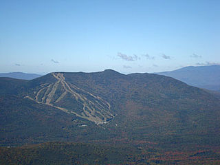
Loon Mountain is a mountain in Lincoln and Livermore, New Hampshire, in Grafton County. It is in the White Mountain National Forest.

Kilkenny is a township in Coös County, New Hampshire, United States. It lies entirely within the White Mountain National Forest. As of the 2020 census, the township had a population of zero.

The Lost River is a 4.0-mile-long (6.4 km) stream in the White Mountains of New Hampshire in the United States. It is a tributary of Moosilauke Brook, part of the Pemigewasset River watershed leading to the Merrimack River.

Mount Sunapee is a 5-mile-long (8.0 km) mountain ridge in the towns of Newbury and Goshen in western New Hampshire, United States. Its highest peak, at the north end of the mountain, is 2,726 feet (831 m) above sea level. The mountain has three secondary peaks, White Ledges at 2,716 ft (828 m); North Peak at 2,280 ft (695 m); and South Peak at 2,608 ft (795 m). The north end of the mountain, including the summit, is within Mount Sunapee State Park, which encompasses 3.85 square miles (10.0 km2) and is home to the popular Mount Sunapee Resort. The mountain extends south to Pillsbury State Park in the towns of Goshen and Washington.
Mount Waumbek is a mountain located in Coos County, New Hampshire. The mountain is part of the Pliny Range of the White Mountains. Waumbek is flanked to the northeast by Mount Weeks, to the west by Mount Starr King, and to the southeast by Pliny Mountain. Waumbek is drained by various brooks into the Israel River, and thence into the Connecticut River and Long Island Sound.

The Sandwich Range is located in the White Mountains of New Hampshire in the United States, north of the Lakes Region and south of the Kancamagus Highway. Although the range is not outstanding for its elevation, it is very rugged and has excellent views of the surrounding lakes, mountains, and forests.

Mount Tom is a mountain located in Grafton County, New Hampshire, about 1.5 miles (2.4 km) southwest of the height of land of Crawford Notch.
Mount Tecumseh is a mountain located in Grafton County, New Hampshire. The mountain is named after the Shawnee leader Tecumseh, and is a part of the White Mountains. The east side of Tecumseh drains into the Mad River; the west side drains into several brooks. All are tributaries of the Pemigewasset River, which drains into the Merrimack River and thence into the Gulf of Maine in Massachusetts.
Mount Weeks, formerly Round Mountain, is a mountain located in Coos County, New Hampshire. Mt. Weeks is the northeasternmost of the Pliny Range of the White Mountains and the highest point within the city limits of Berlin, New Hampshire. Mount Weeks is flanked to the southwest by South Weeks, and faces Terrace Mountain to the northwest across Willard Notch.

Temple Mountain is a 2,045-foot (623 m) mountain in the Wapack Range in Hillsborough County, New Hampshire, United States.
Bear Mountain is a 3,219-foot (981 m) mountain located in Bartlett, New Hampshire, USA. Bear Mountain is flanked to the northwest, across Bear Notch, by Bartlett Haystack. To the east is Table Mountain, followed by Big Attitash Mountain. The north side of Bear Mountain drains via Louisville Brook and Albany Brook to the Saco River in Bartlett. The southern slopes of the mountain drain to the Swift River, on the southwest via Douglas Brook and on the southeast via Cilley Brook, which joins the Swift River at Rocky Gorge.
Ferncroft is an unincorporated community lying mostly in the town of Albany in Carroll County, New Hampshire, United States. Some of the roads and houses in Ferncroft stretch into the towns of Sandwich and Waterville Valley. The hamlet is a widely spaced cluster of houses centered on several fields lying along the Wonalancet River on Ferncroft Road.

Mount Sniktau is a high mountain summit in the Front Range of the Rocky Mountains of North America. The 13,240-foot (4,036 m) thirteener is located in Arapaho National Forest, 1.6 miles (2.5 km) northeast of Loveland Pass in Clear Creek County, Colorado, United States.