Wolfeboro (CDP), New Hampshire

Last updated

Wolfeboro, New Hampshire
Wolfeboro RR station March 2019.jpg
The former Wolfeboro Railroad station in the center of Wolfeboro village
USA New Hampshire location map.svg
Red pog.svg
Wolfeboro
Usa edcp location map.svg
Red pog.svg
Wolfeboro
Coordinates: 43°35′6″N71°12′34″W / 43.58500°N 71.20944°W / 43.58500; -71.20944
Country United States
State New Hampshire
County Carroll
Town Wolfeboro
Area
[1]
  Total8.19 sq mi (21.21 km2)
  Land7.86 sq mi (20.36 km2)
  Water0.33 sq mi (0.85 km2)
Elevation
545 ft (166 m)
Population
 (2020)
  Total3,300
  Density419.79/sq mi (162.08/km2)
Time zone UTC-5 (Eastern (EST))
  Summer (DST) UTC-4 (EDT)
ZIP code
03894 (Wolfeboro)
03896 (Wolfeboro Falls)
Area code 603
FIPS code 33-86340
GNIS feature ID2378098

Wolfeboro is a census-designated place (CDP) in the town of Wolfeboro in Carroll County, New Hampshire, United States. It consists of the main village of Wolfeboro within the town, as well as the smaller village of Wolfeboro Falls. The population of the CDP was 3,300 at the 2020 census, [2] out of 6,416 in the entire town of Wolfeboro.

Contents

Geography

The CDP is in the southern part of the town of Wolfeboro, between Lake Winnipesaukee to the south and Lake Wentworth to the northeast. New Hampshire Route 28 is the main highway through the village, entering from the southeast as Tuftonboro Road, then turning northeast on Center Street. NH 28 leads south 11 miles (18 km) to Alton and northeast 9 miles (14 km) to Ossipee. New Hampshire Route 109 enters Wolfeboro village from the west on North Main Street, then joins NH 28 to leave to the northeast on Center Street. NH 109 leads northwest 10 miles (16 km) to Melvin Village in the town of Tuftonboro and east 12 miles (19 km) to Sanbornville in the town of Wakefield. New Hampshire Route 109A (Elm Street) departs from NH 28/109 in Wolfeboro Falls, leading northwest 17 miles (27 km) to Moultonborough.

The Wolfeboro CDP is bordered to the south by Winter Harbor and Wolfeboro Bay of Lake Winnipesaukee, from Keewaydin Road in the west to a line between Sinclair Lane and Mountain West Drive in the east. The eastern edge of the CDP follows Cross Road and Pleasant Valley Road northeast to Heath Brook, then follows the brook northwest downstream to Lake Wentworth. The CDP border follows the western shore of Lake Wentworth north to Hodges Road, then follows Trotting Track Road west to Beach Pond Road, and south to NH 109A. The western edge of the CDP is Waumbeck Road from NH 109A south to a brook just north of NH 109, then follows the brook west to Keewaydin Road. [3]

According to the U.S. Census Bureau, the Wolfeboro CDP has a total area of 8.2 square miles (21.2 km2), of which 7.9 square miles (20.4 km2) are land and 0.3 square miles (0.9 km2), or 4.02%, are water. [4]

Demographics

Historical population
CensusPop.Note
1950 1,271
1960 1,55722.5%
1970 1,71810.3%
1980 2,27132.2%
1990 2,78322.5%
2000 2,9797.0%
2010 2,838−4.7%
2020 3,30016.3%
U.S. Decennial Census [5]

As of the 2010 census, there were 2,838 people, 1,353 households, and 795 families residing in the CDP. There were 1,858 housing units, of which 505 (27.2%) were vacant. 355 of the vacant units were seasonal or vacation units. The racial makeup of the town was 97.6% White, 0.2% African American, 0.2% Native American, 0.7% Asian, 0.1% some other race, and 1.3% from two or more races. 1.5% of the population were Hispanic or Latino of any race. [6]

Of the 1,353 households in the CDP, 19.6% had children under the age of 18 living with them, 47.6% were headed by married couples living together, 7.9% had a female householder with no husband present, and 41.2% were non-families. 36.7% of all households were made up of individuals, and 20.1% were someone living alone who was 65 years of age or older. The average household size was 2.04, and the average family size was 2.61. [6]

Within the CDP, 16.2% of the population were under the age of 18, 5.1% were from 18 to 24, 15.2% were from 25 to 44, 31.3% were from 45 to 64, and 32.2% were 65 years of age or older. The median age was 54.0 years. For every 100 females, there were 88.1 males. For every 100 females age 18 and over, there were 85.0 males. [6]

For the period 2011–15, the estimated median annual income for a household was $62,019, and the median income for a family was $69,091. The per capita income for the CDP was $36,899. 10.1% of the population and 4.8% of families were below the poverty line. 11.1% of all residents under the age of 18 and 1.6% of those 65 or older were living in poverty. [7]

Related Research Articles

<span class="mw-page-title-main">Carroll County, New Hampshire</span> County in New Hampshire, United States

Carroll County is a county in the U.S. state of New Hampshire. As of the 2020 census, the population was 50,107, making it the third-least populous county in New Hampshire. Its county seat is Ossipee. The county was created in 1840 and organized at Ossipee from towns removed from Strafford County. It was named in honor of Charles Carroll of Carrollton, who had died in 1832, the last surviving signer of the United States Declaration of Independence.

<span class="mw-page-title-main">Alton, New Hampshire</span> Town in New Hampshire, United States

Alton is a town in Belknap County, New Hampshire, United States. The population was 5,894 at the 2020 census, up from 5,250 at the 2010 census. It is home to Alton Bay State Forest and Mount Major State Forest.

<span class="mw-page-title-main">Center Harbor, New Hampshire</span> Town in New Hampshire, United States

Center Harbor is a town in Belknap County, New Hampshire, United States. As of the 2020 census, the town had a population of 1,040. It is situated between Lake Winnipesaukee and Squam Lake.

<span class="mw-page-title-main">Sanbornton, New Hampshire</span> Town in New Hampshire, United States

Sanbornton is a town in Belknap County, New Hampshire, United States. The population was 3,026 at the 2020 census. It includes the villages of North Sanbornton and Gaza.

<span class="mw-page-title-main">Moultonborough, New Hampshire</span> Town in New Hampshire, United States

Moultonborough is a town in Carroll County, New Hampshire, United States. The population was 4,918 at the 2020 census, up from 4,044 at the 2010 census. Moultonborough is bounded in large part by Lake Winnipesaukee in the southwest and to a lesser extent by Squam Lake in the northwest corner. The town includes the census-designated place of Suissevale and the community of Lees Mill.

<span class="mw-page-title-main">Tuftonboro, New Hampshire</span> Town in New Hampshire, United States

Tuftonboro is a town in Carroll County, New Hampshire, United States. The population was 2,467 at the 2020 census. Bounded on the southwest by Lake Winnipesaukee, Tuftonboro includes the villages of Tuftonboro Corner, Center Tuftonboro, Melvin Village and Mirror Lake.

<span class="mw-page-title-main">Tilton Northfield, New Hampshire</span> Census-designated place in New Hampshire, United States

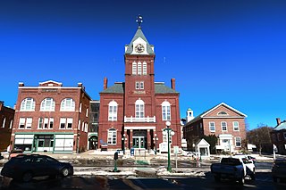
Tilton Northfield is a census-designated place (CDP) representing two adjacent villages in the towns of Tilton in Belknap County and Northfield in Merrimack County in the U.S. state of New Hampshire. The CDP encompasses the town centers of both Tilton and Northfield, located on either side of the Winnipesaukee River. The population was 3,324 at the 2020 census.

<span class="mw-page-title-main">Lake Winnipesaukee</span> Lake in New Hampshire, U.S.

Lake Winnipesaukee is the largest lake in the U.S. state of New Hampshire, located in the Lakes Region at the foothills of the White Mountains. It is approximately 21 miles (34 km) long (northwest-southeast) and from 1 to 9 miles wide (northeast-southwest), covering 69 square miles (179 km2)—71 square miles (184 km2) when Paugus Bay is included—with a maximum depth of 180 feet (55 m). The center area of the lake is called The Broads.

<span class="mw-page-title-main">Meredith (CDP), New Hampshire</span> Census-designated place in New Hampshire, United States

Meredith is a census-designated place (CDP) and the main village in the town of Meredith in Belknap County, New Hampshire, United States. The population was 2,527 at the 2020 census, out of 6,662 in the entire town of Meredith.

<span class="mw-page-title-main">Meredith, New Hampshire</span> Town in New Hampshire, United States

Meredith is a town in Belknap County, New Hampshire, United States. The population was 6,662 at the 2020 census. Meredith is situated in the state's Lakes Region and serves as a major resort town. Meredith Village, the commercial center of the town, lies long the shores of Lake Winnipesaukee, and several other large lakes lie partially or completely within the town borders. It is home to the Stonedam Island Natural Area and the Winnipesaukee Scenic Railroad, and it serves as one of the ports of call for the MS Mount Washington.

<span class="mw-page-title-main">Wolfeboro, New Hampshire</span> Town in New Hampshire, United States

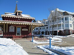
Wolfeboro is a town in Carroll County, New Hampshire, United States. The population was 6,416 at the 2020 census. A resort area situated beside Lake Winnipesaukee, Wolfeboro includes the village of Wolfeboro Falls.

<span class="mw-page-title-main">Newport (CDP), New Hampshire</span> Census-designated place in New Hampshire, United States

Newport is a census-designated place (CDP) comprising the main village and surrounding rural land in the town of Newport, Sullivan County, New Hampshire, United States. The population of the CDP was 4,735 at the 2020 census, out of 6,299 in the entire town.

<span class="mw-page-title-main">New Hampshire Route 28</span> State highway in eastern New Hampshire, US

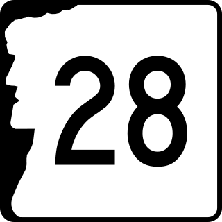
New Hampshire Route 28 is an 85.413-mile-long (137.459 km) north–south state highway in eastern New Hampshire. It connects the town of Ossipee in east-central New Hampshire with Salem on the Massachusetts border, while passing through Manchester, the largest city in the state.

<span class="mw-page-title-main">New Hampshire Route 109</span> State highway in Carroll County, New Hampshire, US

New Hampshire Route 109 is a 41.029-mile-long (66.030 km) north–south highway in Carroll County, New Hampshire. It runs southeast from Sandwich to the Maine border.

<span class="mw-page-title-main">Melvin Village, New Hampshire</span> Census-designated place in New Hampshire, United States

Melvin Village is a census-designated place (CDP) within the town of Tuftonboro in Carroll County, New Hampshire, United States. Its population at the 2020 census was 273. The village is a summer vacation spot on Melvin Bay of Lake Winnipesaukee.

<span class="mw-page-title-main">Center Sandwich, New Hampshire</span> Census-designated place in New Hampshire, United States

Center Sandwich is a census-designated place in the town of Sandwich in Carroll County, New Hampshire, in the United States. It is the primary settlement in the town and had a population of 156 at the 2020 census. The village center and surrounding area are listed on the National Register of Historic Places as the Center Sandwich Historic District.

Mirror Lake is an unincorporated community in the town of Tuftonboro in Carroll County, New Hampshire. It is located along the shore of Mirror Lake in the Lakes Region of New Hampshire.

Alton is a census-designated place (CDP) and the main village in the town of Alton in Belknap County, New Hampshire, United States. The population was 499 at the 2020 census, compared to 5,894 in the entire town of Alton.

Suissevale is a private subdivision in the town of Moultonborough in Carroll County, New Hampshire, United States. It is located between New Hampshire Route 109 and Moultonborough Bay, an arm of Lake Winnipesaukee. The subdivision is listed as a census-designated place (CDP) and had a year-round population of 328 as of the 2020 census.

<span class="mw-page-title-main">Wolfeboro Falls, New Hampshire</span> Unincorporated community in New Hampshire, United States

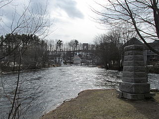
Wolfeboro Falls is an unincorporated community in the town of Wolfeboro in Carroll County, New Hampshire, United States. It is located 0.5 miles (0.8 km) north of the center of Wolfeboro, on the strip of land separating Front Bay from Crescent Lake. The stream connecting the two lakes, known as the "Smith River", drops 28 feet (8.5 m) over its 0.3-mile (0.5 km) course.

References

  1. "ArcGIS REST Services Directory". United States Census Bureau. Retrieved September 20, 2022.
  2. "Wolfeboro CDP, New Hampshire: 2020 DEC Redistricting Data (PL 94-171)". U.S. Census Bureau. Retrieved November 2, 2021.
  3. "TIGERweb: Wolfeboro CDP, New Hampshire". Geography Division, U.S. Census Bureau. Retrieved January 25, 2021.
  4. "2021 U.S. Gazetteer Files – New Hampshire". United States Census Bureau. Retrieved November 2, 2021.
  5. "Decennial Census Official Publications". Census.gov. Retrieved March 4, 2024.
  6. 1 2 3 "Profile of General Population and Housing Characteristics: 2010 Census Summary File 1 (DP-1): Wolfeboro CDP, New Hampshire". U.S. Census Bureau, American Factfinder. Archived from the original on February 13, 2020. Retrieved August 25, 2017.
  7. "Selected Economic Characteristics: 2011-2015 American Community Survey 5-Year Estimates (DP03): Wolfeboro CDP, New Hampshire". U.S. Census Bureau, American Factfinder. Archived from the original on February 13, 2020. Retrieved August 25, 2017.