Center Conway, New Hampshire

Last updated
Center Conway, New Hampshire
Unincorporated community
Center-conway-town-hall-united-methodist-church.JPG
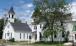
Main street of Center Conway, New Hampshire. On the right is the old Town House, and on the left is the United Methodist Church.
USA New Hampshire location map.svg
Red pog.svg
Center Conway
Usa edcp location map.svg
Red pog.svg
Center Conway
Coordinates: 43°59′44″N71°03′40″W / 43.99556°N 71.06111°W / 43.99556; -71.06111 Coordinates: 43°59′44″N71°03′40″W / 43.99556°N 71.06111°W / 43.99556; -71.06111
Country United States
State New Hampshire
County Carroll
Town Conway
Elevation 459 ft (140 m)
Time zone UTC-5 (Eastern (EST))
  Summer (DST) UTC-4 (EDT)
ZIP code 03813
Area code(s) 603
GNIS feature ID 871651 [1]

Center Conway is an unincorporated community within the town of Conway in Carroll County, New Hampshire, United States. From the late 19th century until the Second World War, Center Conway was known for its corn cannery. Today the homes are mostly residential, with many vacationers visiting the scenic Conway Lake. The old corn farms have given way to modern businesses, though summer corn is still harvested from local corn fields.

Unincorporated area Region of land not governed by own local government

In law, an unincorporated area is a region of land that is not governed by a local municipal corporation; similarly an unincorporated community is a settlement that is not governed by its own local municipal corporation, but rather is administered as part of larger administrative divisions, such as a township, parish, borough, county, city, canton, state, province or country. Occasionally, municipalities dissolve or disincorporate, which may happen if they become fiscally insolvent, and services become the responsibility of a higher administration. Widespread unincorporated communities and areas are a distinguishing feature of the United States and Canada. In most other countries of the world, there are either no unincorporated areas at all, or these are very rare; typically remote, outlying, sparsely populated or uninhabited areas.

New England town Basic unit of local government in each of the six New England federated states of the United States

The New England town, generally referred to simply as a town in New England, is the basic unit of local government and local division of state authority in each of the six New England states and without a direct counterpart in most other U.S. states. New England towns overlay the entire area of a state, similar to civil townships in other states where they exist, but they are fully functioning municipal corporations, possessing powers similar to cities in other states. New Jersey's system of equally powerful townships, boroughs, towns, and cities is the system which is most similar to that of New England. New England towns are often governed by a town meeting legislative body. The great majority of municipal corporations in New England are based on the town model; statutory forms based on the concept of a compact populated place are uncommon, though they are prevalent elsewhere in the U.S. County government in New England states is typically weak at best, and in some states nonexistent. Connecticut, for example, has no county governments, nor does Rhode Island. Both of those states retain counties only as geographic subdivisions with no governmental authority, while Massachusetts has abolished eight of fourteen county governments so far. With few exceptions, counties serve mostly as dividing lines for the states' judicial systems.

Conway, New Hampshire Town in New Hampshire, United States

Conway is a town in Carroll County, New Hampshire, United States. It is the most populous community in the county, and the most populous in the state north of Lake Winnipesaukee. The population was 10,115 at the 2010 census, more than 1/5 of the total population of Carroll County. The town is near the southeastern edge of White Mountain National Forest. Cathedral Ledge and Echo Lake State Park are in the west. There are five villages in the town: Conway, North Conway, Center Conway, Redstone and Kearsarge. Additionally, it shares a portion of the village of Intervale with the neighboring town of Bartlett.

Contents

History

Center Conway is the oldest settlement of Conway, New Hampshire. The first annual town meeting of Conway was held there on February 20, 1770, by Thomas Merrill and Joshua Heath. Until the town house was built in 1837, the town meetings were held in homes or taverns. [2]

Seasonal vacationers

Town beach on Conway Lake in Center Conway Center-conway-town-beach.JPG
Town beach on Conway Lake in Center Conway

Though the village has grown during the last century, most of its inhabitants are holiday visitors, who take advantage of the scenic setting surrounding Conway Lake and the White Mountains. Formerly, visitors came only in the summer, but more and more families are winterizing their summer homes for skiing on nearby Mt. Cranmore.[ citation needed ]

White Mountains (New Hampshire) mountain range in New England, United States

The White Mountains are a mountain range covering about a quarter of the state of New Hampshire and a small portion of western Maine in the United States. They are part of the northern Appalachian Mountains and the most rugged mountains in New England. The range is heavily visited due to its proximity to Boston and, to a lesser extent, New York City and Montreal, Quebec, Canada.

Cranmore Mountain Resort

Cranmore Mountain Resort, operating in the summer as Cranmore Mountain Adventure Park, is a ski area located in North Conway, New Hampshire, United States. It began operations in 1937, and was owned until 1984 by the Schneider family. During the late 1980s and 1990s, ownership of the resort changed hands several times; it is now owned by a group of New England businessmen and is undergoing several years of expansion and modernization.

Related Research Articles

Finger Lakes group of lakes in New York, USA

The Finger Lakes are a group of 11 long, narrow, roughly north–south lakes in an area informally called the Finger Lakes region in Central New York, in the United States. This region straddles the northern and transitional edge, known as the Finger Lakes Uplands and Gorges ecoregion, of the Northern Allegheny Plateau and the Ontario Lowlands ecoregion of the Great Lakes Lowlands.

New Preston, Connecticut census designated place

New Preston is a rural village in the northwestern corner of the town of Washington in Litchfield County, Connecticut, United States. The village is also at the center of a census-designated place (CDP), whose population was 1,110 at the 2000 census.

Alton, New Hampshire Town in New Hampshire, United States

Alton is a town in Belknap County, New Hampshire, United States. The population was 5,250 at the 2010 census. It is home to Alton Bay State Forest and Mount Major State Forest.

Center Harbor, New Hampshire Town in New Hampshire, United States

Center Harbor is a town located in Belknap County, New Hampshire, United States. As of the 2010 census, the town had a total population of 1,096. It is situated between Lake Winnipesaukee and Squam Lake.

North Conway, New Hampshire Census-designated place in New Hampshire, United States

North Conway is a census-designated place (CDP) and village in eastern Carroll County, New Hampshire, United States. The population was 2,349 at the 2010 census. A year-round resort area, North Conway is the largest village within the town of Conway, which is bounded on the east by the Maine state line. The White Mountain National Forest is to the west and north. Conway is home to Cathedral Ledge, Echo Lake State Park, and Mount Cranmore. North Conway is known for its large number of outlet shops.

Holderness, New Hampshire Town in New Hampshire, United States

Holderness is a town in Grafton County, New Hampshire, United States. The population was 2,108 at the 2010 census. An agricultural and resort area, Holderness is home to the Squam Lakes Natural Science Center and is located on Squam Lake. Holderness is also home to Holderness School, a co-educational college-preparatory boarding school.

New London, New Hampshire Town in New Hampshire, United States

New London is a town in Merrimack County, New Hampshire, United States. The population was 4,397 at the 2010 census. The town is the home of Colby–Sawyer College.

Pioneer Valley

The Pioneer Valley is the colloquial and promotional name for the portion of the Connecticut River Valley that is in Massachusetts in the United States. It is generally taken to comprise the three counties of Hampden, Hampshire, and Franklin. The lower Pioneer Valley corresponds to the Springfield, Massachusetts metropolitan area, the region's urban center, and the seat of Hampden County. The upper Pioneer Valley region includes the smaller cities of Northampton and Greenfield, the county seats of Hampshire and Franklin counties.

Meredith, New Hampshire Town in New Hampshire, United States

Meredith is a town in Belknap County, New Hampshire, United States. The population was 6,241 at the 2010 census. Meredith is situated beside Lake Winnipesaukee. It is home to the Stonedam Island Natural Area and the Winnipesaukee Scenic Railroad.

U.S. Route 302 is an east–west spur of U.S. Route 2 in northern New England in the United States. It currently runs 171 miles (275 km) from Montpelier, Vermont, beginning at US 2, to Portland, Maine, at U.S. Route 1. It passes through the states of Vermont, New Hampshire and Maine.

White Mountains Region tourist region that encompasses the New Hampshire mountain range

The White Mountains Region is a tourism region designated by the New Hampshire Division of Travel and Tourism. It is located in northern New Hampshire in the United States and is named for the White Mountains, which cover most of the region. The southern boundary of the region begins at Piermont on the west, and runs to Plymouth, then to Conway, and east to the Maine border. The northern boundary begins at Cushman, runs to Berlin and then east to the Maine border. The region to the north is known as the Great North Woods Region, which should not be confused with the larger and more general Great North Woods.

Crawford Notch mountain pass

Crawford Notch is a major pass through the White Mountains of New Hampshire, located almost entirely within the town of Hart's Location. Roughly half of that town is contained in Crawford Notch State Park. The high point of the notch, at approximately 1,900 feet (580 m) above sea level, is at the southern end of the town of Carroll, near the Crawford Depot train station and Saco Lake, the source of the Saco River, which flows southward through the steep-sided notch. North of the high point of the notch, Crawford Brook flows more gently northwest to the Ammonoosuc River, a tributary of the Connecticut River.

Squam Lake Lake in Belknap County, New Hampshire

Squam Lake is a lake located in the Lakes Region of central New Hampshire, United States, south of the White Mountains, straddling the borders of Grafton, Carroll, and Belknap counties. The largest town center on the lake is Holderness. The lake is located northwest of much larger Lake Winnipesaukee.

Plymouth & Lincoln Railroad a set of two heritage railroads in central New Hampshire, in the United States

The Plymouth & Lincoln Railroad is a railroad operating on the Concord-Lincoln rail line in central New Hampshire, United States. The railroad consists of two distinct passenger operations, the Hobo Railroad, which offers passenger excursion trains in the White Mountains, and the Winnipesaukee Scenic Railroad, which operates passenger excursion trains along the shore of Lake Winnipesaukee in the Lakes Region of New Hampshire. In addition to passenger operations, the railroad owns the Lincoln Shops, a railroad equipment maintenance and repair facility located in Lincoln, New Hampshire.

Conway Lake lake in United States of America

Conway Lake is a 1,316-acre (5 km2) water body with a maximum depth of 45 feet (14 m), located in Carroll County in eastern New Hampshire, in the United States. The lake is located in the towns of Conway and Eaton, just to the east of the White Mountains, and is part of the Saco River watershed.

Dublin Pond Lake in Cheshire County, New Hampshire

Dublin Pond or Dublin Lake is a 236-acre (0.96 km2) water body located in Cheshire County in southwestern New Hampshire, United States, in the town of Dublin. The pond lies at an elevation of 1,480 feet (451 m) above sea level, near the height of land between the Connecticut River/Long Island Sound watershed to the west and the Merrimack River/Gulf of Maine watershed to the east.

Alton Bay, New Hampshire Unincorporated community in New Hampshire, United States

Alton Bay is an unincorporated community in the town of Alton, New Hampshire, United States, and is located on Alton Bay, a 4-mile-long (6 km) cove of Lake Winnipesaukee which forms the southernmost point on the lake. The village is part of the Lakes Region, a popular resort area of New Hampshire.

Crawford Depot (Carroll, New Hampshire)

Crawford Depot, also known as Maine Central Passenger Railway Station, is a historic passenger railroad station at the top of Crawford Notch in the Bretton Woods area of the town of Carroll, New Hampshire. Built in 1891, it is a surviving emblem of the importance of the railroad in the area's history as a tourist destination, and is one of the finest examples of Queen Anne railroad architecture in northern New England. Now home to a visitors center operated by the Appalachian Mountain Club, it was listed on the National Register of Historic Places in 1982. It is also the northern terminus of most trains on the "Notch Train" service of the Conway Scenic Railroad.

References

  1. "Center Conway". Geographic Names Information System . United States Geological Survey.
  2. Conway, New Hampshire 1765-1997, by Janet McAllister Hounsell and Ruth Burnham Davis Horne (Portsmouth: Peter Randall Publisher, 1998)