West Ossipee, New Hampshire

Last updated
West Ossipee, New Hampshire
Unincorporated community

WestOssipeeNHSept2016.jpg

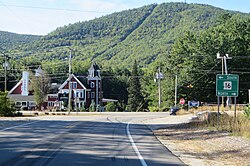
Intersection of NH 16 and NH 41 in West Ossipee. Nickerson Mountain, site of former Mt. Whittier Ski Area, rises in background.
USA New Hampshire location map.svg
Red pog.svg
West Ossipee
Usa edcp location map.svg
Red pog.svg
West Ossipee
Coordinates: 43°49′29″N71°12′19″W / 43.82472°N 71.20528°W / 43.82472; -71.20528 Coordinates: 43°49′29″N71°12′19″W / 43.82472°N 71.20528°W / 43.82472; -71.20528
Country United States
State New Hampshire
County Carroll
Town Ossipee
Elevation 433 ft (132 m)
Time zone Eastern (EST) (UTC-5)
  Summer (DST) EDT (UTC-4)
ZIP code 03890
Area code(s) 603
GNIS feature ID 870784 [1]

West Ossipee is an unincorporated community in the town of Ossipee in Carroll County, New Hampshire, United States. It is located near the northern boundary of the town, along New Hampshire Route 16, leading north towards Conway and south towards Rochester. Route 41 departs from the village, heading northeast to Silver Lake and Madison. Route 25 leads west towards Tamworth and Moultonborough. The Bearcamp River runs along the southwest side of the village. The Whittier Bridge is a historic covered bridge that crosses the river just west of the village.

Unincorporated area Region of land not governed by own local government

In law, an unincorporated area is a region of land that is not governed by a local municipal corporation; similarly an unincorporated community is a settlement that is not governed by its own local municipal corporation, but rather is administered as part of larger administrative divisions, such as a township, parish, borough, county, city, canton, state, province or country. Occasionally, municipalities dissolve or disincorporate, which may happen if they become fiscally insolvent, and services become the responsibility of a higher administration. Widespread unincorporated communities and areas are a distinguishing feature of the United States and Canada. In most other countries of the world, there are either no unincorporated areas at all, or these are very rare; typically remote, outlying, sparsely populated or uninhabited areas.

Ossipee, New Hampshire Town in New Hampshire, United States

Ossipee is a town in Carroll County, New Hampshire, United States. The population was 4,345 at the 2010 census. It is the county seat of Carroll County. Ossipee, which includes several villages, is a resort area and home to part of Pine River State Forest.

Carroll County, New Hampshire County in the United States

Carroll County is a county in the U.S. state of New Hampshire. As of the 2010 census, the population was 47,818, making it the third-least populous county in New Hampshire. Its county seat is Ossipee. The county was created in 1840 and organized at Ossipee from towns removed from Strafford County. It was named in honor of Charles Carroll of Carrollton, who had died in 1832, the last surviving signer of the United States Declaration of Independence.

West Ossipee has a separate ZIP code (03890) from the rest of Ossipee.

Related Research Articles

Moultonborough, New Hampshire Town in New Hampshire, United States

Moultonborough is a town in Carroll County, New Hampshire, United States. The population was 4,044 at the 2010 census. Moultonborough is bounded in part by Lake Winnipesaukee in the southwest and Squam Lake in the northwest corner. The town includes the census-designated place of Suissevale and the community of Lees Mill.

Tamworth, New Hampshire Town in New Hampshire, United States

Tamworth is a town in Carroll County, New Hampshire, United States. The population was 2,856 at the 2010 census. Tamworth includes the villages of Chocorua, South Tamworth, Wonalancet, and Whittier. The White Mountain National Forest is to the north. The town is home to Hemenway State Forest in the north and White Lake State Park in the southeast.

New Hampshire Route 16 highway in New Hampshire

New Hampshire Route 16 is a 149.75-mile (241.00 km) long north–south highway in New Hampshire, the main road connecting the Seacoast region to the Lakes Region and the White Mountains. Much of its length is close to the border with Maine. The section from Portsmouth to Milton is a controlled-access toll highway known as the Spaulding Turnpike. Between Milton and Chocorua, and between Conway and Glen, it is known as the White Mountain Highway. It is known as Chocorua Mountain Highway between Chocorua and Conway and various other local names before crossing into Maine about 20 miles south of the Canadian border. Portions of NH 16 run concurrent with US 4, US 202, NH 25, and US 302, and US 2.

New Hampshire Route 153 highway in New Hampshire

New Hampshire Route 153 is a 50.566-mile-long (81.378 km) secondary north–south highway in Strafford and Carroll counties in eastern New Hampshire. The southern terminus is in Farmington at New Hampshire Route 11. The northern terminus is in Conway village at New Hampshire Route 16 and New Hampshire Route 113.

New Hampshire Route 171 highway in New Hampshire

New Hampshire Route 171 is a 15.194-mile-long (24.452 km) east–west highway in southern Carroll County in the Lakes Region of New Hampshire. The highway runs from NH 109 in Moultonborough to NH 16 in Ossipee.

Squamscott River river in the United States of America

The Squamscott River is a 6-mile-long (9.7 km) tidal river in Rockingham County, southeastern New Hampshire, in the United States. It rises at Exeter, fed by the Exeter River. The Squamscott runs north between Newfields and Stratham to Great Bay, a tidal estuary, which is connected to the Piscataqua River, a tidal inlet of the Atlantic Ocean.

Ossipee River river in New Hampshire and Maine, United States

The Ossipee River is an 18.3-mile-long (29.5 km) river in eastern New Hampshire and western Maine in the United States. It is a tributary of the Saco River, which flows southeast to the Atlantic Ocean at Saco, Maine.

Pine River (New Hampshire) river located in eastern New Hampshire in the United States

The Pine River is a 19.2-mile-long (30.9 km) river located in eastern New Hampshire in the United States. It is a tributary of Ossipee Lake, part of the Saco River watershed leading to the Atlantic Ocean.

Bearcamp River river in the United States of America

The Bearcamp River is a 26.3-mile-long (42.3 km) river at the southern edge of the White Mountains in New Hampshire, the United States. It is the largest tributary of Ossipee Lake, part of the Saco River watershed leading to the Atlantic Ocean.

Chocorua River river in the United States of America

The Chocorua River is a 15.2-mile (24.5 km) river located in eastern New Hampshire in the United States. It is a tributary of the Bearcamp River, part of the Ossipee Lake / Saco River watershed leading to the Atlantic Ocean.

The Melvin River is an 8.1-mile-long (13.0 km) river located in the Lakes Region of central New Hampshire in the United States. It is a tributary of Lake Winnipesaukee, part of the Merrimack River watershed.

The Whiteface River is a 5.9-mile-long (9.5 km) river rising in the White Mountains of New Hampshire in the United States. Its waters flow by way of the Cold River, Bearcamp River, Ossipee Lake, the Ossipee River and the Saco River into the Gulf of Maine, an arm of the Atlantic Ocean.

West Branch (New Hampshire) river in eastern New Hampshire, United States

The West Branch is a 5.5-mile (8.9 km) long river located in eastern New Hampshire in the United States. It is the northern tributary of Ossipee Lake, part of the Saco River watershed leading to the Atlantic Ocean.

The Lovell River is a 9.5-mile (15.3 km) long river located in eastern New Hampshire in the United States. It is a tributary of Ossipee Lake, part of the Saco River watershed leading to the Atlantic Ocean.

The Dan Hole River is a 5.1-mile (8.2 km) long river in the town of Ossipee in eastern New Hampshire in the United States. Its waters flow via the Beech River, Pine River, Ossipee Lake, the Ossipee River, and the Saco River to the Gulf of Maine, an arm of the Atlantic Ocean.

Center Ossipee, New Hampshire Census-designated place in New Hampshire, United States

Center Ossipee is a census-designated place in the town of Ossipee in Carroll County, New Hampshire. The population was 561 at the 2010 census. It is one of two major villages in the town, the other being Ossipee Corner. Center Ossipee has a separate ZIP code (03814) from other portions of the town of Ossipee.

Whittier Bridge

The Whittier Bridge is a historic wooden covered bridge in Ossipee, New Hampshire. The bridge carried an old alignment of New Hampshire Route 25 over the Bearcamp River. Built in 1870, it is one of New Hampshire's few surviving 19th-century covered bridges, and a rare example of a Paddleford truss. The bridge was listed on the National Register of Historic Places in 1984. It was closed to vehicular traffic in 1989, and was removed from its footings for restoration in 2008. It is presently resting on Nudd Road adjacent to the crossing point.

South Tamworth, New Hampshire Unincorporated community in New Hampshire, United States

South Tamworth is an unincorporated community in the town of Tamworth in Carroll County, New Hampshire, United States. It is located along New Hampshire Route 25, next to the Bearcamp River. Route 25 continues east past the village of Whittier to West Ossipee, where it intersects New Hampshire Route 16. To the west, Route 25 leads to Moultonborough, Center Harbor, and Meredith.

Wolfeboro Falls, New Hampshire Unincorporated community in New Hampshire, United States

Wolfeboro Falls is an unincorporated community in the town of Wolfeboro in Carroll County, New Hampshire, United States. It is located 0.5 miles (0.8 km) north of the center of Wolfeboro, on the strip of land separating Front Bay from Crescent Lake. The stream connecting the two lakes, known as the "Smith River", drops 28 feet (8.5 m) over its 0.3-mile (0.5 km) course.

References