
Moultonborough is a town in Carroll County, New Hampshire, United States. The population was 4,918 at the 2020 census, up from 4,044 at the 2010 census. Moultonborough is bounded in large part by Lake Winnipesaukee in the southwest and to a lesser extent by Squam Lake in the northwestern corner. The town includes the census-designated place of Suissevale and the community of Lees Mill.
East Merrimack is a census-designated place (CDP) in the town of Merrimack, Hillsborough County, New Hampshire, United States. There is no village center named "East Merrimack"; rather, the CDP refers to the region of the town of Merrimack lying east of the F. E. Everett Turnpike, overlapping portions of the villages of Reeds Ferry, Thornton's Ferry, and the center of Merrimack. The population was 5,176 at the 2020 census, up from 4,197 at the 2010 census.

Meredith is a census-designated place (CDP) and the main village in the town of Meredith in Belknap County, New Hampshire, United States. The population was 2,527 at the 2020 census, out of 6,662 in the entire town of Meredith.
Conway is a census-designated place (CDP) and the primary village in the town of Conway in Carroll County, New Hampshire, United States. The population was 3,576 at the 2020 census. It is the most populous community in the town of Conway, ahead of North Conway.

Wolfeboro is a census-designated place (CDP) in the town of Wolfeboro in Carroll County, New Hampshire, United States. It consists of the main village of Wolfeboro within the town, as well as the smaller village of Wolfeboro Falls. The population of the CDP was 3,300 at the 2020 census, out of 6,416 in the entire town of Wolfeboro.
Lancaster is a census-designated place (CDP) and the main village in the town of Lancaster in Coos County, New Hampshire, United States. The population of the CDP was 1,941 at the 2020 census, out of 3,218 in the entire town of Lancaster.

Bristol is a census-designated place (CDP) and the main village in the town of Bristol in Grafton County, New Hampshire, United States. The population of the CDP was 1,911 at the 2020 census, out of 3,244 in the entire town.
Littleton is a census-designated place (CDP) and the main village in the town of Littleton in Grafton County, New Hampshire, United States. The population of the CDP was 4,467 at the 2020 census, out of 6,005 in the entire town.

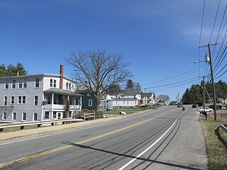
Melvin Village is a census-designated place (CDP) within the town of Tuftonboro in Carroll County, New Hampshire, United States. Its population at the 2020 census was 273. The village is a summer vacation spot on Melvin Bay of Lake Winnipesaukee.

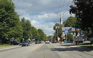
Sanbornville is a census-designated place (CDP) and the primary village in the town of Wakefield, Carroll County, New Hampshire, United States. It had a population of 963 at the 2020 census.

Milton Mills is a small village and census-designated place in the town of Milton, Strafford County, New Hampshire, United States. It had a population of 313 at the 2020 census. Milton Mills has a separate ZIP code (03852) from the rest of the town of Milton.

Center Sandwich is a census-designated place in the town of Sandwich in Carroll County, New Hampshire, United States. It is the primary settlement in the town and had a population of 156 at the 2020 census. The village center and surrounding area are listed on the National Register of Historic Places as the Center Sandwich Historic District.
Milton is a census-designated place (CDP) and the primary village in the town of Milton, Strafford County, New Hampshire, United States. The population of the CDP was 593 at the 2020 census, out of 4,482 in the entire town.

Newfields is a census-designated place (CDP) and the main village within the town of Newfields, Rockingham County, New Hampshire, United States. The population of the CDP was 378 at the 2020 census, out of 1,769 in the entire town.
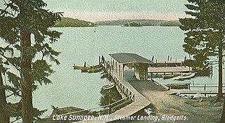
Blodgett Landing is a census-designated place in the town of Newbury, Merrimack County, New Hampshire, United States. It had a population of 152 at the 2020 census, up from 101 at the 2010 census.

Bradford is a census-designated place (CDP) and the main village in the town of Bradford in Merrimack County, New Hampshire, United States. The population of the CDP was 372 at the 2020 census, out of 1,662 in the entire town.

Hancock is a census-designated place (CDP) and the main village in the town of Hancock in Hillsborough County, New Hampshire, United States. The population of the CDP was 213 at the 2020 census, out of 1,731 in the entire town.

Lincoln is a census-designated place (CDP) and the main village in the town of Lincoln in Grafton County, New Hampshire, United States. The population of the CDP was 969 at the 2020 census, out of 1,631 in the entire town.
Plainfield is a census-designated place (CDP) and the namesake village in the town of Plainfield, Sullivan County, New Hampshire, United States. The population of the CDP was 178 at the 2020 census, out of 2,459 in the entire town.

Warner is a census-designated place (CDP) and the main village in the town of Warner in Merrimack County, New Hampshire, United States. The population of the CDP was 453 at the 2020 census, out of 2,937 in the entire town.


