Bartlett, New Hampshire

Last updated

Bartlett, New Hampshire
Town
BartlettNH SchoolAndLibrary.jpg
Bartlett Elementary School and Library
Motto: 
"In the Heart of the White Mountains"
Carroll-Bartlett-NH.png
Coordinates: 44°04′40″N71°16′58″W / 44.07778°N 71.28278°W / 44.07778; -71.28278
Country United States
State New Hampshire
County Carroll
Incorporated 1790
Villages
Government
   Board of Selectmen
Area
[1]
  Total75.2 sq mi (194.8 km2)
  Land74.8 sq mi (193.7 km2)
  Water0.4 sq mi (1.1 km2)  0.57%
Elevation
671 ft (205 m)
Population
 (2020) [2]
  Total3,200
  Density43/sq mi (16.5/km2)
Time zone UTC-5 (Eastern)
  Summer (DST) UTC-4 (Eastern)
ZIP codes
03812 (Bartlett)
03838 (Glen)
03845 (Intervale)
03860 (North Conway)
Area code 603
FIPS code 33-03700
GNIS feature ID0873539
Website www.townofbartlettnh.org

Bartlett is a town in Carroll County, New Hampshire, United States. The population was 3,200 at the 2020 census, [2] up from 2,788 at the 2010 census. [3] Bartlett includes the unincorporated community of Glen as well as portions of the communities of Kearsarge and Intervale, which the town shares with the neighboring town of Conway. It is set in the White Mountains and is surrounded by the White Mountain National Forest. It is home to the Attitash Mountain Resort and the Story Land theme park.

Contents

The main village in town, where 351 people resided at the 2020 census, is defined by the U.S. Census Bureau as the Bartlett census-designated place and is located at the intersection of U.S. Route 302 with Bear Notch Road (Albany Avenue).

History

Howard Hotel c. 1920 Howard Hotel, Bartlett, NH.jpg
Howard Hotel c.1920

Settled after 1769 and incorporated in 1790, the town is named for Dr. Josiah Bartlett, the first chief executive to bear the name "governor", a representative to the Continental Congress, and one of New Hampshire's three signers of the Declaration of Independence. Dr. Bartlett founded the New Hampshire Medical Society in 1791. Bartlett became a railroad town in 1875 when the Maine Central Railroad's Mountain Division was built. In 1954, Story Land, a theme park designed for young children, opened in Glen. Attitash ski area opened in the 1960s.

The Bartlett Roundhouse in Bartlett village was listed on the National Register of Historic Places in September 2015. [4]

Tourism

Bartlett's views of the White Mountains have long made tourism a principal business. The town has one covered bridge. Attitash ski area is the second largest ski area in New Hampshire.[ citation needed ] Bartlett also is home to the Bear Notch Ski Touring area affording Nordic ski enthusiasts trails in the upper Saco River Valley. Bartlett is also an attraction for railfans. The Conway Scenic Railroad, a heritage railway in nearby North Conway, operates a train to the town daily for sightseeing in the spring, summer, and fall.

Geography

According to the United States Census Bureau, the town has a total area of 75.2 square miles (194.8 km2), of which 74.8 square miles (193.7 km2) are land and 0.4 square miles (1.1 km2), or 0.57%, are water. [1] Bartlett is drained by the Saco River and its tributary, the Ellis River. The highest point in Bartlett is Mount Tremont, elevation 3,371 feet (1,027 m). Mount Parker, elevation 3,004 ft (916 m), is in the north, and Bear Mountain, elevation 3,200 ft (980 m), is on the southern boundary.

In addition to the town center, Bartlett includes the following villages within its limits:

Goodrich Falls on the Ellis River is in the northern part of the town, next to NH 16.

Demographics

Historical population
CensusPop.Note
1850 761
1860 735−3.4%
1870 629−14.4%
1880 1,04466.0%
1890 1,24719.4%
1900 1,013−18.8%
1910 1,19718.2%
1920 1,059−11.5%
1930 1,1195.7%
1940 1,1543.1%
1950 1,074−6.9%
1960 1,013−5.7%
1970 1,0988.4%
1980 1,56642.6%
1990 2,29046.2%
2000 2,70518.1%
2010 2,7883.1%
2020 3,20014.8%
U.S. Decennial Census [2] [5]
Diana's Baths on Lucy Brook Diana's Baths, Bartlett, NH.jpg
Diana's Baths on Lucy Brook
Kearsarge Peg Mill c. 1910 Kearsarge Peg Mill, Bartlett, NH.jpg
Kearsarge Peg Mill c.1910

As of the census of 2010, there were 2,788 people, 1,307 households, and 762 families residing in the town. There were 4,115 housing units, of which 2,808, or 68.2%, were vacant. 2,691 of the vacant units were for seasonal or recreational use. The racial makeup of the town was 97.7% white, 0.3% African American, 0.3% Native American, 0.4% Asian, 0.0% Native Hawaiian or Pacific Islander, 0.0% some other race, and 1.3% from two or more races. 0.9% of the population were Hispanic or Latino of any race. [6]

Of the 1,307 households, 21.8% had children under the age of 18 living with them, 46.4% were headed by married couples living together, 8.1% had a female householder with no husband present, and 41.7% were non-families. 31.4% of all households were made up of individuals, and 11.3% were someone living alone who was 65 years of age or older. The average household size was 2.13, and the average family size was 2.66. [6]

In the town, 17.4% of the population were under the age of 18, 5.2% were from 18 to 24, 20.7% from 25 to 44, 36.3% from 45 to 64, and 20.5% were 65 years of age or older. The median age was 49.0 years. For every 100 females, there were 99.3 males. For every 100 females age 18 and over, there were 99.2 males. [6]

For the period 2011-2015, the estimated median annual income for a household was $50,536, and the median income for a family was $80,229. The per capita income for the town was $35,700. 10.0% of the population and 5.0% of families were below the poverty line. 8.2% of the population under the age of 18 and 5.7% of those 65 or older were living in poverty. [7]

Transportation

Two New Hampshire State Routes and one U.S. Route cross Bartlett.

Related Research Articles

<span class="mw-page-title-main">Carroll County, New Hampshire</span> County in New Hampshire, United States

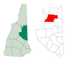
Carroll County is a county in the U.S. state of New Hampshire. As of the 2020 census, the population was 50,107, making it the third-least populous county in New Hampshire. Its county seat is Ossipee. The county was created in 1840 and organized at Ossipee from towns removed from Strafford County. It was named in honor of Charles Carroll of Carrollton, who had died in 1832, the last surviving signer of the United States Declaration of Independence.

<span class="mw-page-title-main">Albany, New Hampshire</span> Town in New Hampshire, United States

Albany is a town in Carroll County, New Hampshire, United States. The population was 759 at the 2020 census.

<span class="mw-page-title-main">Chatham, New Hampshire</span> Town in New Hampshire, United States

Chatham is a town in Carroll County, New Hampshire, United States. The population was 341 at the 2020 census. It is located in the White Mountains, and except for the southeast corner, all of Chatham is in the White Mountain National Forest. The town is home to the Cold River national forest campgrounds.

<span class="mw-page-title-main">Hart's Location, New Hampshire</span> Town in New Hampshire, United States

Hart's Location is a town in Carroll County, New Hampshire, United States. Since 1948, the town has been one of the first places to declare its results for the New Hampshire presidential primary and U.S. presidential elections.

<span class="mw-page-title-main">Jackson, New Hampshire</span> Town in New Hampshire, United States

Jackson is a town in Carroll County, New Hampshire, United States. The population was 1,028 at the 2020 census, up from 816 at the 2010 census. Jackson is a resort area in the White Mountains. Parts of the White Mountain National Forest are in the west, north and east.

<span class="mw-page-title-main">Madison, New Hampshire</span> Town in New Hampshire, United States

Madison is a town in Carroll County, New Hampshire, United States. The population was 2,565 at the 2020 census. Madison includes the village of Silver Lake and the village district of Eidelweiss.

<span class="mw-page-title-main">North Conway, New Hampshire</span> Census-designated place in New Hampshire, United States

North Conway is a census-designated place (CDP) and village in eastern Carroll County, New Hampshire, United States. The population was 2,116 at the 2020 census. A year-round resort area, North Conway is the second-largest village within the town of Conway, after the village of Conway proper. North Conway maintains its own fire station, post office and public library, sharing its other services with Conway. The White Mountain National Forest is to the west and north. The area is home to Cathedral Ledge, Echo Lake State Park, and Cranmore Mountain Resort. North Conway is known for its large number of outlet shops.

<span class="mw-page-title-main">Sandwich, New Hampshire</span> Town in New Hampshire, United States

Sandwich is a town in Carroll County, New Hampshire, United States. Its population was 1,466 at the 2020 census. Sandwich includes the villages of Center Sandwich and North Sandwich. Part of the White Mountain National Forest is in the north, and part of Squam Lake is in the southwestern corner of the town. As such, Sandwich lies on the boundary between New Hampshire's Lakes Region and White Mountains Region. The Sandwich Range of the White Mountains lies partially within the town, as does the namesake Sandwich Mountain. The town is home to the Sandwich Fair, a popular agricultural fair that occurs every October.

<span class="mw-page-title-main">Tamworth, New Hampshire</span> Town in New Hampshire, United States

Tamworth is a town in Carroll County, New Hampshire, United States. The population was 2,812 at the 2020 census. Tamworth includes the villages of Chocorua, South Tamworth, Wonalancet, and Whittier. The White Mountain National Forest is to the north. The town is home to Hemenway State Forest in the north and White Lake State Park in the southeast.

<span class="mw-page-title-main">Carroll, New Hampshire</span> Town in New Hampshire, United States

Carroll is a town in Coös County, New Hampshire, United States. The population was 820 at the 2020 census. The two largest villages are Twin Mountain and Bretton Woods. Carroll is an important access point for recreational areas in the White Mountains, including many 4,000-footers, the Zealand River area, the Presidential Range, and the Presidential Dry River Wilderness. The town is home to the Mount Washington Hotel at Bretton Woods and to the Highland Center at Crawford Notch, the Appalachian Mountain Club's four-season lodge.

<span class="mw-page-title-main">Pinkham's Grant, New Hampshire</span> Township in Coos County, New Hampshire, United States

Pinkham's Grant is a township in Coös County, New Hampshire, United States. The grant lies entirely within the White Mountain National Forest. As of the 2020 United States census, the population of the grant was zero.

<span class="mw-page-title-main">Waterville Valley, New Hampshire</span> Town in New Hampshire, United States

Waterville Valley is a New England town in Grafton County, New Hampshire, United States. The population was 508 at the 2020 census, up from 247 at the 2010 census.

<span class="mw-page-title-main">Conway, New Hampshire</span> Town in New Hampshire, United States

Conway is a town in Carroll County, New Hampshire, United States. It is the most populous community in the county, with a population of 9,822 at the 2020 census, down from 10,115 at the 2010 census. The town is on the southeastern edge of the White Mountain National Forest. There are five villages in the town: Conway, North Conway, Center Conway, Redstone and Kearsarge. Additionally, it shares a portion of the village of Intervale with the neighboring town of Bartlett.

<span class="mw-page-title-main">U.S. Route 302</span> Numbered Highway in the US states of Vermont, New Hampshire, and Maine

U.S. Route 302 is an east–west spur of U.S. Route 2 in northern New England in the United States. It currently runs 171 miles (275 km) from Montpelier, Vermont, beginning at US 2, to Portland, Maine, at U.S. Route 1. It passes through the states of Vermont, New Hampshire and Maine.

<span class="mw-page-title-main">White Mountains Region</span>

The White Mountains Region is a tourism region designated by the New Hampshire Division of Travel and Tourism. It is located in northern New Hampshire in the United States and is named for the White Mountains, which cover most of the region. The southern boundary of the region begins at Piermont on the west, and runs east to Campton, then on to Conway and the Maine border. The northern boundary begins at Littleton and runs east to Gorham and the Maine border. The region to the north is known as the Great North Woods Region, which should not be confused with the larger and more general Great North Woods.

<span class="mw-page-title-main">Crawford Notch</span> Major pass through White Mountains in New Hampshire, US

Crawford Notch is a major pass through the White Mountains of New Hampshire, located in Hart's Location. Roughly half of that town is contained in Crawford Notch State Park. The high point of the notch, at approximately 1,900 feet (580 m) above sea level, is at the southern end of the town of Carroll, near the Crawford Depot train station and Saco Lake, the source of the Saco River, which flows southward through the steep-sided notch. North of the high point of the notch, Crawford Brook flows more gently northwest to the Ammonoosuc River, a tributary of the Connecticut River.

<span class="mw-page-title-main">New Hampshire Route 16</span> North-south state highway in New Hampshire, US

New Hampshire Route 16 is a 154.771-mile (249.080 km), north–south state highway in New Hampshire, United States, the main road connecting the Seacoast region to the Lakes Region and the White Mountains. Much of its length is close to the border with Maine. The section from Portsmouth to Milton is a controlled-access toll highway known as the Spaulding Turnpike. Between Milton and Chocorua, and between Conway and Glen, it is known as the White Mountain Highway. It is known as Chocorua Mountain Highway between Chocorua and Conway and various other local names before crossing into Maine about 20 miles (32 km) south of the Canadian border. Portions of NH 16 run concurrent with U.S. Route 4 (US 4), US 202, NH 25, and US 302, and US 2.

<span class="mw-page-title-main">Ellis River (New Hampshire)</span> River in New Hampshire, United States

The Ellis River is a 16-mile-long (26 km) river in the White Mountains of New Hampshire in the United States. It is a tributary of the Saco River, which flows to the Atlantic Ocean in Maine.

<span class="mw-page-title-main">Bear Mountain (New Hampshire)</span> Mountain in the American state of New Hampshire

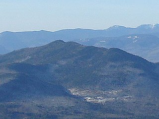
Bear Mountain is a 3,219-foot (981 m) mountain located in Bartlett, New Hampshire, USA. Bear Mountain is flanked to the northwest, across Bear Notch, by Bartlett Haystack. To the east is Table Mountain, followed by Big Attitash Mountain. The north side of Bear Mountain drains via Louisville Brook and Albany Brook to the Saco River in Bartlett. The southern slopes of the mountain drain to the Swift River, on the southwest via Douglas Brook and on the southeast via Cilley Brook, which joins the Swift River at Rocky Gorge.

<span class="mw-page-title-main">Bartlett (CDP), New Hampshire</span> Census-designated place in New Hampshire, United States

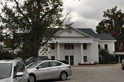
Bartlett is a census-designated place (CDP) and the main village in the town of Bartlett in Carroll County, New Hampshire, United States. The population was 351 at the 2020 census, out of 3,200 in the entire town of Bartlett.

References

  1. 1 2 "2020 U.S. Gazetteer Files – New Hampshire". United States Census Bureau. Retrieved October 29, 2021.
  2. 1 2 3 "Bartlett town, Carroll County, New Hampshire: 2020 DEC Redistricting Data (PL 94-171)". U.S. Census Bureau. Retrieved October 29, 2021.
  3. United States Census Bureau, American FactFinder, 2010 Census figures. Retrieved March 23, 2011.
  4. "Weekly List of Actions Taken on Properties: 9/28/15 through 10/02/15". National Park Service: National Register of Historic Places. Retrieved October 14, 2015.
  5. "Census of Population and Housing". Census.gov. Retrieved June 4, 2016.
  6. 1 2 3 "Profile of General Population and Housing Characteristics: 2010 Census Summary File 1 (DP-1): Bartlett town, Carroll County, New Hampshire". U.S. Census Bureau, American Factfinder. Archived from the original on February 13, 2020. Retrieved October 25, 2017.
  7. "Selected Economic Characteristics: 2011-2015 American Community Survey 5-Year Estimates (DP03): Bartlett town, Carroll County, New Hampshire". U.S. Census Bureau, American Factfinder. Archived from the original on February 13, 2020. Retrieved October 25, 2017.