Goodrich Falls

Last updated
Good Rich Falls, Bartlett, N.H, by Pease, N. W. (Nathan W.), 1836-1918 2.png
Goodrich Falls in Bartlett, New Hampshire Below Good Rich Falls, looking up, Bartlett, N.H, by Pease, N. W. (Nathan W.), 1836-1918.png
Goodrich Falls in Bartlett, New Hampshire
Good Rich Falls, Bartlett, N.H, by Pease, N. W. (Nathan W.), 1836-1918 3.png
Good Rich Falls, Bartlett, N.H, by Pease, N. W. (Nathan W.), 1836-1918.jpg
Postcard of Goodrich Falls Cabins on New Hampshire Route 16 Some of our cabins, Goodrich Falls Cabins, Route 16, 1 mile south of Jackson, N.H (77818).jpg
Postcard of Goodrich Falls Cabins on New Hampshire Route 16

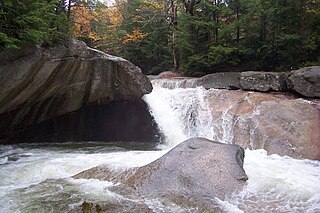
Goodrich Falls is a populated place in the town of Bartlett along the Ellis River in Carroll County, New Hampshire, United States. The falls were featured in stereoscopic images in the 19th century including by Kilburn Brothers and Nathan W. Pease. New Hampshire Route 16 bridges the river just upstream from the falls.

Bartlett, New Hampshire Town in New Hampshire, United States

Bartlett is a town in Carroll County, New Hampshire, United States. The population was 2,788 at the 2010 census. Bartlett includes the unincorporated community of Glen as well as portions of the communities of Kearsarge and Intervale which the town shares with the neighboring town of Conway. It is set in the White Mountains and is surrounded by the White Mountain National Forest. It is home to the Attitash Mountain Resort and the Story Land theme park.

Ellis River (New Hampshire) river in United States of America

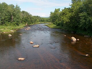
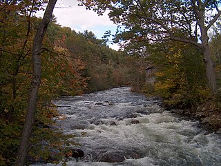
The Ellis River is a 16.7-mile-long (26.9 km) river in the White Mountains of New Hampshire in the United States. It is a tributary of the Saco River, which flows to the Atlantic Ocean in Maine.

Carroll County, New Hampshire County in the United States

Carroll County is a county in the U.S. state of New Hampshire. As of the 2010 census, the population was 47,818, making it the third-least populous county in New Hampshire. Its county seat is Ossipee. The county was created in 1840 and organized at Ossipee from towns removed from Strafford County. It was named in honor of Charles Carroll of Carrollton, who had died in 1832, the last surviving signer of the United States Declaration of Independence.

The Goodrich Falls Hydroelectric Plant was completed in 1935. [1] It was built by Edwin Moody, owner of the Black Mountain Ski Area (then known as Moody's), and Phil Robertson. Moody and local inventor George Morton constructed one of the first ski lifts in New Hampshire and used the plant to power the lift and lodge. Goodrich Falls Hydroelectric Corporation took over the plant in 1977. [1]

Ski lift Transport device that carries skiers up a hill

Snowcat service in Colorado, USA]]

In 1899, the town of Jackson paid the Goodrich Falls Electric Company to illuminate Honeymoon Bridge, a wooden covered bridge over the Ellis River. [2]

Jackson, New Hampshire Town in New Hampshire, United States

Jackson is a town in Carroll County, New Hampshire, United States. The population was 816 at the 2010 census. Jackson is an elegant resort area in the White Mountains. Parts of the White Mountain National Forest are in the west, north and east.

Honeymoon Bridge (New Hampshire) bridge in United States of America

Honeymoon Bridge is a wooden covered bridge over the Ellis River in Jackson, New Hampshire, United States.

Covered bridge wooden bridge with protective cover

A covered bridge is a timber-truss bridge with a roof, decking, and siding, which in most covered bridges, create an almost complete enclosure. The purpose of the covering is to protect the wooden structural members from the weather. Uncovered wooden bridges typically have a lifespan of only 20 years because of the effects of rain and sun, but a covered bridge could last 100 years.

Related Research Articles

White Mountains Region tourist region that encompasses the New Hampshire mountain range

The White Mountains Region is a tourism region designated by the New Hampshire Division of Travel and Tourism. It is located in northern New Hampshire in the United States and is named for the White Mountains, which cover most of the region. The southern boundary of the region begins at Piermont on the west, and runs to Plymouth, then to Conway, and east to the Maine border. The northern boundary begins at Cushman, runs to Berlin and then east to the Maine border. The region to the north is known as the Great North Woods Region, which should not be confused with the larger and more general Great North Woods.

Israel River river in the United States of America

The Israel River, sometimes referred to as Israel's River, is a river in the White Mountains of New Hampshire, in the United States. It rises in the township of Low and Burbank's Grant and runs 24 miles (39 km) generally northwest along U.S. Highway 2, traversing the towns of Jefferson and Lancaster, before joining the Connecticut River.

Androscoggin River river in New Hampshire and Maine, United States

The Androscoggin River is a river in the U.S. states of Maine and New Hampshire, in northern New England. It is 178 miles (286 km) long and joins the Kennebec River at Merrymeeting Bay in Maine before its water empties into the Gulf of Maine on the Atlantic Ocean. Its drainage basin is 3,530 square miles (9,100 km2) in area. The name "Androscoggin" comes from the Eastern Abenaki term /aləssíkɑntəkw/ or /alsíkɑntəkw/, meaning "river of cliff rock shelters" ; or perhaps from Penobscot /aləsstkɑtəkʷ/, meaning "river of rock shelters". The Anglicization of the Abenaki term is likely an analogical contamination with the colonial governor Edmund Andros.

Pemigewasset River river in the United States of America

The Pemigewasset River, known locally as "The Pemi", is a river in the state of New Hampshire, the United States. It is 65.0 miles (104.6 km) in length and drains approximately 1,021 square miles (2,644 km2). The name "Pemigewasset" comes from the Abenaki word bemijijoasek [bəmidzidzoasək], meaning "where side (entering) current is".

Piscataquog River river in the United States of America

The Piscataquog River is a 34.7-mile-long (55.8 km) river located in southern New Hampshire in the United States. It is a tributary of the Merrimack River, which flows to the Gulf of Maine.

Newfound River (New Hampshire) river in the United States of America

The Newfound River is a 3.2-mile-long (5.1 km) river located in central New Hampshire in the United States. It is a tributary of the Pemigewasset River, part of the Merrimack River watershed.

East Branch Pemigewasset River river in the United States of America

The East Branch of the Pemigewasset River is a 15.8-mile-long (25.4 km) river located in the White Mountains of New Hampshire in the United States. It is a tributary of the Pemigewasset River, part of the Merrimack River watershed.

Smith River (Pemigewasset River tributary) river in central New Hampshire, United States

The Smith River is a 25.0-mile-long (40.2 km) river located in central New Hampshire in the United States. It is a tributary of the Pemigewasset River, part of the Merrimack River watershed.

Rocky Branch (New Hampshire) river in the United States of America

The Rocky Branch is a 13.1 mile long river in the White Mountains of New Hampshire in the United States. It is a tributary of the Saco River, which flows to the Atlantic Ocean in Maine.

East Branch Saco River river in the United States of America

The East Branch of the Saco River is a 13.2-mile-long (21.2 km) river in the White Mountains of New Hampshire in the United States. It is a tributary of the Saco River, which flows to the Atlantic Ocean in Maine.

The North Fork of the East Branch of the Pemigewasset River is a 6.9-mile-long (11.1 km) river located in the White Mountains of New Hampshire in the United States. It is a tributary of the East Branch of the Pemigewasset River, part of the Merrimack River watershed.

The East Fork of the East Branch of the Saco River is a 2.2-mile (3.5 km) long stream in the White Mountains of New Hampshire in the United States. It is a tributary of the East Branch of the Saco River, with its waters ultimately flowing to the Atlantic Ocean in Maine.

The New River is a 2.2-mile (3.5 km) long stream in the White Mountains of New Hampshire in the United States. It is a tributary of the Ellis River, part of the Saco River watershed flowing to the Atlantic Ocean in Maine. The river is within the townships of Sargent's Purchase and Pinkham's Grant in Coos County.

Black Mountain Ski Area (New Hampshire)

Black Mountain is an alpine ski area located in Jackson, New Hampshire, United States. It offers terrain for all abilities, including slopes for novices, cruising trails for intermediates, and black diamond trails for experts. The terrain is served by two chairlifts and three surface lifts.

Mount Tremont, elevation 3,371 feet (1,027 m), is a mountain in Carroll and Grafton counties in the White Mountains of New Hampshire. It stands southwest of the town of Bartlett and directly south of Crawford Notch. It is flanked to the east by Bartlett Haystack mountain, to the northwest by the Sawyer River valley, and to the northeast by the Saco River valley. The mountain is crossed by the Brunel and Mount Tremont trails.

Wildcat Brook

Wildcat Brook, also known as the Wildcat River, is a 9.05-mile-long (14.56 km) stream in the White Mountains of New Hampshire, in the United States. It rises at Carter Notch in the township of Bean's Purchase in Coos County, and flows south through the town of Jackson in Carroll County to its confluence with the Ellis River near the town's southern boundary. At Jackson Falls, near the town center, the stream descends 120 feet (37 m) in 14 mile (0.4 km) over scenic granite ledges, paralleled by New Hampshire Route 16B. The surrounding area is part of the Jackson Falls Historic District.

References

  1. 1 2 Goodrich Falls Bartlett Historical Society
  2. "HONEYMOON BRIDGE Jackson, New Hampshire". www.nh.gov. Retrieved 2014-12-04.

Coordinates: 44°7′34″N71°11′24″W / 44.12611°N 71.19000°W / 44.12611; -71.19000

Geographic coordinate system Coordinate system

A geographic coordinate system is a coordinate system that enables every location on Earth to be specified by a set of numbers, letters or symbols. The coordinates are often chosen such that one of the numbers represents a vertical position and two or three of the numbers represent a horizontal position; alternatively, a geographic position may be expressed in a combined three-dimensional Cartesian vector. A common choice of coordinates is latitude, longitude and elevation. To specify a location on a plane requires a map projection.