Wentworth, New Hampshire

Last updated

Wentworth, New Hampshire
Town
Wentworth Common Gazebo Church.JPG
Wentworth Common
Grafton-Wentworth-NH.png
Coordinates: 43°52′08″N71°54′36″W / 43.86889°N 71.91000°W / 43.86889; -71.91000
Country United States
State New Hampshire
County Grafton
Incorporated 1766
Government
   Select Board
  • Arnold D. Scheller, Chair
  • Brian DuBois
  • Rick Ducheneau Sr.
Area
[1]
  Total42.1 sq mi (109.0 km2)
  Land41.6 sq mi (107.7 km2)
  Water0.5 sq mi (1.3 km2)  1.22%
Elevation
630 ft (190 m)
Population
 (2020) [2]
  Total845
  Density20/sq mi (7.8/km2)
Time zone UTC-5 (Eastern)
  Summer (DST) UTC-4 (Eastern)
ZIP code
03282
Area code 603
FIPS code 33-80500
GNIS feature ID0873752
Website www.wentworth-nh.org

Wentworth is a town in Grafton County, New Hampshire, United States. The population was 845 at the 2020 census, [2] down from 911 at the 2010 census. [3] The town is home to Plummer's Ledge Natural Area, and part of the White Mountain National Forest is in the northeast. The town has a picturesque common, presided over by a Federal-style church and bordered by antique homes.

Contents

History

It was granted by Governor Benning Wentworth on November 1, 1766, to John Page and 60 others. Named for the governor himself, [4] Wentworth was settled and incorporated the same year. Many of the settlers arrived from Massachusetts, particularly Salisbury. With a pretty New England common set atop an elevated tongue of land, the village has been noted since the 19th century for its charm; while in "... beauties of landscape, Wentworth has a more than ordinary share." [5]

Farmers cultivated the rich soil on the intervales. The Boston, Concord & Montreal Railroad diagonally crossed the town. With abundant water power from the Baker River, Wentworth developed into a lumber-producing town with nine sawmills. But disaster struck on August 6, 1856, when dams on the Upper and Lower Baker ponds in Orford breached during a flood, releasing a wall of water down Pond Brook to the Baker River. It raced 3 miles (5 km) down the steep, rocky channel, then undermined and washed away Wentworth's riverside mills, houses, barns, sheds and roads. It widened the river by nearly 90 feet (27 m). [5]

Geography

According to the United States Census Bureau, the town has a total area of 42.1 square miles (109.0 km2), of which 41.6 square miles (107.7 km2) are land and 0.5 square miles (1.3 km2), or 1.22%, are water. [1] The town is drained by the Baker River and its South Branch, part of the Pemigewasset and Merrimack River watersheds. The highest point in Wentworth is Carr Mountain in the northeast corner of town, at 3,453 feet (1,052 m) above sea level.

The town is crossed north to south by New Hampshire Route 25 and New Hampshire Route 118. New Hampshire Route 25A starts at Routes 25 and 118 at the town center and proceeds west into Orford.

Demographics

Historical population
CensusPop.Note
1790 241
1800 488102.5%
1810 64532.2%
1820 80725.1%
1830 92414.5%
1840 1,11921.1%
1850 1,1977.0%
1860 1,055−11.9%
1870 971−8.0%
1880 939−3.3%
1890 698−25.7%
1900 617−11.6%
1910 595−3.6%
1920 507−14.8%
1930 459−9.5%
1940 4917.0%
1950 413−15.9%
1960 300−27.4%
1970 37625.3%
1980 52740.2%
1990 63019.5%
2000 79826.7%
2010 91114.2%
2020 845−7.2%
U.S. Decennial Census [2] [6]

As of the census [7] of 2000, there were 798 people, 310 households, and 220 families residing in the town. The population density was 19.2 people per square mile (7.4/km2). There were 437 housing units at an average density of 10.5 per square mile (4.1/km2). The racial makeup of the town was 97.62% White, 0.38% African American, 0.25% Asian, 0.13% from other races, and 1.63% from two or more races. Hispanic or Latino of any race were 0.38% of the population.

There were 310 households, out of which 31.9% had children under the age of 18 living with them, 60.0% were married couples living together, 7.4% had a female householder with no husband present, and 29.0% were non-families. 21.3% of all households were made up of individuals, and 8.4% had someone living alone who was 65 years of age or older. The average household size was 2.57 and the average family size was 3.04.

In the town, the population was spread out, with 25.8% under the age of 18, 5.8% from 18 to 24, 29.6% from 25 to 44, 24.7% from 45 to 64, and 14.2% who were 65 years of age or older. The median age was 40 years. For every 100 females, there were 100.4 males. For every 100 females age 18 and over, there were 101.4 males.

The median income for a household in the town was $44,219, and the median income for a family was $47,917. Males had a median income of $31,250 versus $24,500 for females. The per capita income for the town was $18,258. About 6.1% of families and 7.9% of the population were below the poverty line, including 9.7% of those under age 18 and 2.6% of those age 65 or over.

Government

Wentworth uses a town meeting form of government administered by a three-member Board of Selectmen serving staggered three-year terms, with one seat elected each year. In the New Hampshire General Court, Wentworth is in the Grafton 11th and 16th House Districts, represented by Beth Folsom (R) and Jeffrey Greeson (R), respectively. Wentworth is in Senate District 2, represented by Bob Giuda (R).

Climate

According to the Köppen Climate Classification system, Wentworth has a warm-summer humid continental climate, abbreviated "Dfb" on climate maps. The hottest temperature recorded in Wentworth was 97 °F (36.1 °C) on August 16, 2002 and August 1213, 2016, while the coldest temperature recorded was −25 °F (−31.7 °C) on January 1617, 2009. [8]

Climate data for Wentworth, New Hampshire, 1991–2020 normals, extremes 2000–present
MonthJanFebMarAprMayJunJulAugSepOctNovDecYear
Record high °F (°C)60
(16)
64
(18)
85
(29)
90
(32)
95
(35)
95
(35)
96
(36)
97
(36)
96
(36)
82
(28)
78
(26)
65
(18)
97
(36)
Mean maximum °F (°C)46.6
(8.1)
50.7
(10.4)
58.6
(14.8)
73.1
(22.8)
86.4
(30.2)
89.2
(31.8)
90.8
(32.7)
88.9
(31.6)
86.1
(30.1)
73.6
(23.1)
63.8
(17.7)
50.0
(10.0)
92.5
(33.6)
Average high °F (°C)29.4
(−1.4)
33.1
(0.6)
42.2
(5.7)
55.5
(13.1)
68.4
(20.2)
76.6
(24.8)
82.0
(27.8)
80.7
(27.1)
72.5
(22.5)
58.6
(14.8)
46.3
(7.9)
35.2
(1.8)
56.7
(13.7)
Daily mean °F (°C)18.2
(−7.7)
20.6
(−6.3)
29.8
(−1.2)
42.3
(5.7)
54.3
(12.4)
63.3
(17.4)
68.6
(20.3)
66.9
(19.4)
59.5
(15.3)
46.9
(8.3)
35.8
(2.1)
25.4
(−3.7)
44.3
(6.8)
Average low °F (°C)7.0
(−13.9)
8.0
(−13.3)
17.4
(−8.1)
29.0
(−1.7)
40.1
(4.5)
49.9
(9.9)
55.2
(12.9)
53.1
(11.7)
46.4
(8.0)
35.3
(1.8)
25.3
(−3.7)
15.6
(−9.1)
31.9
(−0.1)
Mean minimum °F (°C)−11.4
(−24.1)
−8.8
(−22.7)
−0.7
(−18.2)
19.3
(−7.1)
28.3
(−2.1)
38.1
(3.4)
45.5
(7.5)
44.4
(6.9)
32.8
(0.4)
23.3
(−4.8)
12.6
(−10.8)
−0.8
(−18.2)
−15.1
(−26.2)
Record low °F (°C)−25
(−32)
−24
(−31)
−13
(−25)
5
(−15)
19
(−7)
30
(−1)
42
(6)
40
(4)
26
(−3)
17
(−8)
−4
(−20)
−15
(−26)
−25
(−32)
Average precipitation inches (mm)2.75
(70)
2.30
(58)
3.01
(76)
3.35
(85)
3.56
(90)
4.12
(105)
4.61
(117)
3.87
(98)
3.62
(92)
4.66
(118)
3.50
(89)
3.55
(90)
42.90
(1,090)
Average snowfall inches (cm)17.8
(45)
20.2
(51)
13.3
(34)
3.2
(8.1)
0.1
(0.25)
0.0
(0.0)
0.0
(0.0)
0.0
(0.0)
0.0
(0.0)
0.8
(2.0)
3.0
(7.6)
18.1
(46)
76.5
(193.95)
Average extreme snow depth inches (cm)11.7
(30)
16.7
(42)
13.3
(34)
5.5
(14)
0.1
(0.25)
0.0
(0.0)
0.0
(0.0)
0.0
(0.0)
0.0
(0.0)
0.3
(0.76)
2.6
(6.6)
9.7
(25)
18.2
(46)
Average precipitation days (≥ 0.01 in)11.710.49.411.415.016.115.713.711.316.612.413.1156.8
Average snowy days (≥ 0.1 in)9.89.25.82.10.10.00.00.00.00.42.48.538.3
Source 1: NOAA [9]
Source 2: National Weather Service [8]

Notable people

Related Research Articles

<span class="mw-page-title-main">Hanover, New Hampshire</span> Town in New Hampshire, United States

Hanover is a town located along the Connecticut River in Grafton County, New Hampshire, United States. As of the 2020 census, its population was 11,870. The town is home to the Ivy League university Dartmouth College, the U.S. Army Corps of Engineers Cold Regions Research and Engineering Laboratory, and Hanover High School. The Appalachian Trail crosses the town, connecting with a number of trails and nature preserves.

<span class="mw-page-title-main">Marlow, New Hampshire</span> Town in New Hampshire, United States

Marlow is a town in Cheshire County, New Hampshire, United States. The population was 749 at the 2020 census. Marlow is home to Honey Brook State Forest.

<span class="mw-page-title-main">Errol, New Hampshire</span> Town in New Hampshire, United States

Errol is a town in Coös County, New Hampshire, United States. The population was 298 at the 2020 census. It is located north of the White Mountains along Route 16 at its intersection of Route 26. It has a municipal airport with a single, unpaved runway.

<span class="mw-page-title-main">Ashland, New Hampshire</span> Town in New Hampshire, United States

Ashland is a town in Grafton County, New Hampshire, United States. The population was 1,938 at the 2020 census, down from 2,076 at the 2010 census. Located near the geographical center of the state, Ashland is home to Scribner-Fellows State Forest.

<span class="mw-page-title-main">Bath, New Hampshire</span> Town in New Hampshire, United States

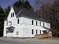
Bath is a town in Grafton County, New Hampshire, United States. The population was 1,077 at the 2020 census, unchanged from the 2010 census. Now a tourist destination and commuter town for Littleton, the town is noted for its historic architecture, including the Brick Store and three covered bridges. Bath includes the village of Swiftwater and part of the district known as Mountain Lakes.

<span class="mw-page-title-main">Benton, New Hampshire</span> Town in New Hampshire, United States

Benton is a town in Grafton County, New Hampshire, United States. The population was 374 at the 2020 census. Located in the White Mountains, Benton is largely surrounded by the White Mountain National Forest. The town is crossed by the Appalachian Trail.

<span class="mw-page-title-main">Campton, New Hampshire</span> Town in New Hampshire, United States

Campton is a town in Grafton County, New Hampshire, United States. The population was 3,343 at the 2020 census. Campton, which includes the villages of Blair, Campton Hollow, Lower Campton and West Campton, is home to Blair State Forest and Livermore Falls State Forest. It is located in the foothills of the White Mountains, and parts of the White Mountain National Forest are in the northeast and northwest.

<span class="mw-page-title-main">Canaan, New Hampshire</span> Town in New Hampshire, United States

Canaan is a town in Grafton County, New Hampshire, United States. The population was 3,794 at the 2020 census. It is the location of Mascoma State Forest. Canaan is home to the Cardigan Mountain School, the town's largest employer.

<span class="mw-page-title-main">Dorchester, New Hampshire</span> Town in New Hampshire, United States

Dorchester is a town in Grafton County, New Hampshire, United States. The population was 339 at the 2020 census.

<span class="mw-page-title-main">Holderness, New Hampshire</span> Town in New Hampshire, United States

Holderness is a town in Grafton County, New Hampshire, United States. The population was 2,004 at the 2020 census. An agricultural and resort area, Holderness is home to the Squam Lakes Natural Science Center and is located on Squam Lake. Holderness is also home to Holderness School, a co-educational college-preparatory boarding school.

<span class="mw-page-title-main">Orange, New Hampshire</span> Town in New Hampshire, United States

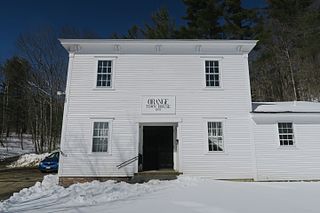
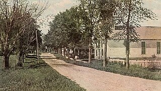
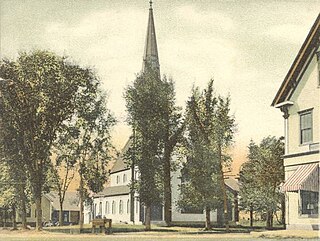
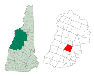
Orange is a town in Grafton County, New Hampshire, United States. The population was 277 at the 2020 census, down from 331 at the 2010 census.

<span class="mw-page-title-main">Orford, New Hampshire</span> Town in New Hampshire, United States

Orford is a town in Grafton County, New Hampshire, United States. The population was 1,237 at the 2020 census, unchanged from the 2010 census. The Appalachian Trail crosses in the east.

<span class="mw-page-title-main">Piermont, New Hampshire</span> Town in New Hampshire, United States

Piermont is a town in Grafton County, New Hampshire, United States. The population was 769 at the 2020 census. It is home to Camp Walt Whitman and Kingswood Camp for Boys.

<span class="mw-page-title-main">Rumney, New Hampshire</span> Town in New Hampshire, United States

Rumney is a town in Grafton County, New Hampshire, United States. The population was 1,498 at the 2020 census. The town is located at the southern edge of the White Mountain National Forest.

<span class="mw-page-title-main">Warren, New Hampshire</span> Town in New Hampshire, United States

Warren is a town in Grafton County, New Hampshire, United States. The population was 825 at the 2020 census, down from 904 at the 2010 census. Warren includes the village of Glencliff. The Appalachian Trail crosses the town in the west.

<span class="mw-page-title-main">Woodstock, New Hampshire</span> Town in New Hampshire, United States

Woodstock is a town in Grafton County, New Hampshire, United States. The population was 1,434 at the 2020 census. Woodstock includes the village of North Woodstock, the commercial center. Its extensive land area is largely forested, and includes the Hubbard Brook Experimental Forest. Parts of the White Mountain National Forest are in the east and west. The Appalachian Trail crosses the town's northwest corner. Russell Pond Campground is in the east. West of North Woodstock is the Lost River Reservation.

<span class="mw-page-title-main">Enfield, New Hampshire</span> Town in New Hampshire, United States

Enfield is a town in Grafton County, New Hampshire, United States. The population was 4,465 at the 2020 census. The town includes the villages of Enfield, Enfield Center, Upper Shaker Village, Lower Shaker Village, Lockehaven, and Montcalm.

<span class="mw-page-title-main">Lisbon, New Hampshire</span> Town in New Hampshire, United States

Lisbon is a town in Grafton County, New Hampshire, United States. The population was 1,621 at the 2020 census. Lisbon hosts an annual lilac festival on Memorial Day weekend.

<span class="mw-page-title-main">Plymouth (CDP), New Hampshire</span> Census-designated place in New Hampshire, United States

Plymouth is a census-designated place (CDP) and the main village in the town of Plymouth in Grafton County, New Hampshire, United States. Its population was 4,730 at the 2020 census, out of 6,682 in the entire town. The CDP includes the campus of Plymouth State University.

<span class="mw-page-title-main">Plymouth, New Hampshire</span> Town in New Hampshire, United States

Plymouth is a rural town in Grafton County, New Hampshire, United States, in the White Mountains Region. It has a unique role as the economic, medical, commercial, and cultural center for the predominantly rural Plymouth, NH Labor Market Area. Plymouth is located at the confluence of the Pemigewasset and Baker rivers and sits at the foot of the White Mountains. The town's population was 6,682 at the 2020 census. It is home to Plymouth State University, Speare Memorial Hospital, and Plymouth Regional High School.

References

  1. 1 2 "2021 U.S. Gazetteer Files – New Hampshire". United States Census Bureau. Retrieved November 30, 2021.
  2. 1 2 3 "Wentworth town, Grafton County, New Hampshire: 2020 DEC Redistricting Data (PL 94-171)". U.S. Census Bureau. Retrieved November 30, 2021.
  3. United States Census Bureau, U.S. Census website, 2010 Census figures. Retrieved March 23, 2011.
  4. New Hampshire Economic and Labor Market Information Bureau Profile
  5. 1 2 Austin J. Coolidge & John B. Mansfield, A History and Description of New England; Boston, Massachusetts
  6. "Census of Population and Housing". Census.gov. Retrieved June 4, 2016.
  7. "U.S. Census website". United States Census Bureau . Retrieved January 31, 2008.
  8. 1 2 "NOAA Online Weather Data – NWS Gray/Portland". National Weather Service. Retrieved November 27, 2022.
  9. "U.S. Climate Normals Quick Access – Station: Wentworth, NH". National Oceanic and Atmospheric Administration. Retrieved November 27, 2022.