Enfield Center, New Hampshire

Last updated

Enfield Center, New Hampshire
Union Church, Enfield Center NH.jpg
USA New Hampshire location map.svg
Red pog.svg
Enfield Center
Usa edcp location map.svg
Red pog.svg
Enfield Center
Coordinates: 43°35′25″N72°06′36″W / 43.59028°N 72.11000°W / 43.59028; -72.11000
Country United States
State New Hampshire
County Grafton
Town Enfield
Elevation
869 ft (265 m)
Time zone UTC-5 (Eastern (EST))
  Summer (DST) UTC-4 (EDT)
ZIP code
03749
Area code 603
GNIS feature ID866803 [1]

Enfield Center is an unincorporated community in the town of Enfield in Grafton County, New Hampshire, United States. It is a separate community from the much larger village of Enfield, which is located in the northern corner of the town.

Enfield Center is located, as the name suggests, near the geographic center of the town of Enfield. It lies along New Hampshire Route 4A, approximately 1 mile (1.6 km) south of the southern end of Mascoma Lake and about 3 miles (5 km) south of Enfield village. The Knox River flows northward through the village on its way from George Pond to Mascoma Lake.

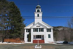
Enfield Center has a separate ZIP code (03749) from the rest of the town of Enfield. Two of its buildings are listed on the National Register of Historic Places; the Centre Village Meeting House (also known as the Union Church) and the Enfield Center Town House.

Related Research Articles

<span class="mw-page-title-main">Lebanon, New Hampshire</span> City in New Hampshire, United States

Lebanon is the only city in Grafton County, New Hampshire, United States. The population was 14,282 at the 2020 census, up from 13,151 at the 2010 census. Lebanon is in western New Hampshire, south of Hanover, near the Connecticut River. It is the home to Dartmouth–Hitchcock Medical Center and Dartmouth College's Geisel School of Medicine, together comprising the largest medical facility between Boston, Massachusetts, and Burlington, Vermont.

Enfield is a census-designated place (CDP) and the main village in the town of Enfield in Grafton County, New Hampshire, United States. The population of the CDP was 1,571 at the 2020 census, out of 4,465 in the entire town.

<span class="mw-page-title-main">Enfield, New Hampshire</span> Town in New Hampshire, United States

Enfield is a town in Grafton County, New Hampshire, United States. The population was 4,465 at the 2020 census. The town includes the villages of Enfield, Enfield Center, Upper Shaker Village, Lower Shaker Village, Lockehaven, and Montcalm.

<span class="mw-page-title-main">New Hampshire Route 10</span> North-south state highway in New Hampshire, US

New Hampshire Route 10 is a 122.25-mile-long (196.74 km) north–south state highway in western New Hampshire, United States. Its southern terminus is in Winchester at the Massachusetts state line, where it continues south as Massachusetts Route 10. Administratively, the northern terminus is at a junction with U.S. Route 302 in Haverhill.

<span class="mw-page-title-main">Mascoma River</span> River in New Hampshire, United States

The Mascoma River is a 31.6-mile-long (50.9 km) river in western New Hampshire in the United States. It is a tributary of the Connecticut River, which flows to Long Island Sound. The Mascoma comprises two sections which are split by Mascoma Lake in the communities of Enfield and Lebanon. Counting the lake would add 2.7 miles (4.3 km) to the river's length.

<span class="mw-page-title-main">Mascoma Lake</span>

Mascoma Lake is a 1,158-acre (469 ha) lake in western New Hampshire, United States. Most of the lake is within the town of Enfield, while a small portion is within the city of Lebanon, where it drains into the Mascoma River, a tributary of the Connecticut River.

Crystal Lake is a 401-acre (1.6 km2) water body located in Grafton County in western New Hampshire, United States, in the town of Enfield. Crystal Lake is part of the Mascoma River watershed.

<span class="mw-page-title-main">Goose Pond (New Hampshire)</span> Lake in New Hampshire, United States

Goose Pond is a 625-acre (2.5 km2) water body located in Grafton County in western New Hampshire, United States, in the towns of Canaan and Hanover. It is considered a great pond by the state of New Hampshire. The lake has 6.3 miles (10.1 km) of shoreline, and is approximately 3 miles (5 km) long by 0.5 miles (0.8 km) wide. All but the northernmost end of the pond is in the town of Canaan. The average depth of the pond is approximately 10 feet (3.0 m), with the deepest part approximately 35 feet (11 m). The lake is part of the Mascoma River watershed, flowing to the Connecticut River.

<span class="mw-page-title-main">Grafton Pond</span> Lake in Grafton County, New Hampshire

Grafton Pond is a 319-acre (1.3 km2) water body located in Grafton County in western New Hampshire, United States, in the town of Grafton. The pond is part of the Mascoma River watershed, flowing to the Connecticut River. Outflow from the pond travels through Bicknell Brook to Crystal Lake in Enfield, then north to the Mascoma River in West Canaan.

The Indian River is a 12.8-mile-long (20.6 km) river in western New Hampshire in the United States. It is a tributary of the Mascoma River, which in turn flows to the Connecticut River and ultimately Long Island Sound.

The Knox River is a 2.5-mile-long (4.0 km) river in western New Hampshire in the United States. The river is an inlet of Mascoma Lake, which drains by the Mascoma River to the Connecticut River and ultimately Long Island Sound.

<span class="mw-page-title-main">North Sutton, New Hampshire</span> Unincorporated community in New Hampshire, United States

North Sutton is an unincorporated community in the town of Sutton in Merrimack County, New Hampshire, United States. It is located at the eastern end of Kezar Lake, adjacent to Wadleigh State Park.

<span class="mw-page-title-main">Alton Bay, New Hampshire</span> Unincorporated community in New Hampshire, United States

Alton Bay is an unincorporated community in the town of Alton, New Hampshire, United States, and is located on Alton Bay, a 4-mile-long (6 km) cove of Lake Winnipesaukee which forms the southernmost point on the lake. The village is part of the Lakes Region, a popular resort area of New Hampshire.

<span class="mw-page-title-main">Georges Mills, New Hampshire</span> Unincorporated community in New Hampshire, United States

Georges Mills is an unincorporated community in the town of Sunapee in Sullivan County, New Hampshire, in the United States. It is located in the northeast corner of the town between the north end of Lake Sunapee and the south shore of Otter Pond. New Hampshire Route 11 runs through the village, leading east to New London and south to the center of Sunapee. It is also served by exit 12A on Interstate 89, 0.5 miles (0.8 km) north of the village.

<span class="mw-page-title-main">U.S. Route 4 in New Hampshire</span> Segment of American highway

U.S. Route 4 (US 4) in the state of New Hampshire runs for 106.834 miles (171.933 km) across the central and southern part of the state, stretching from Lebanon on the Connecticut River border with Vermont southeast to Portsmouth on the eastern coast.

<span class="mw-page-title-main">Enfield Shaker Museum</span> United States historic place

The Enfield Shaker Museum is an outdoor history museum and historic district in Enfield, New Hampshire, in the United States. It is dedicated to preserving and sharing the history of the Shakers, a Protestant religious denomination, who lived on the site from 1793 to 1923. The museum features exhibitions, artifacts, eight Shaker buildings and restored Shaker gardens. It is located in a valley between Mount Assurance and Mascoma Lake in Enfield.

<span class="mw-page-title-main">Moose Mountain (New Hampshire)</span> Mountain ridge in Hanover, New Hampshire, United States

Moose Mountain is an 8-mile (13 km)-long ridge located in the eastern part of the town of Hanover in Grafton County, New Hampshire. The mountain is flanked to the north by Holts Ledge, at 2,110 feet (640 m), and to the south by Shaker Mountain, at 1,690 feet (520 m). It is traversed by the Appalachian Trail, a 2,170-mile (3,490 km) National Scenic Trail from Georgia to Maine. Moose Mountain is outside the White Mountain National Forest, but the trail runs through a narrow corridor along the ridge which is administered by the U.S. Forest Service. The trail can be accessed from the south along Three Mile Road in Hanover, and from the north along Goose Pond Road in Lyme, New Hampshire.

<span class="mw-page-title-main">East Candia, New Hampshire</span> Unincorporated community in New Hampshire, United States

East Candia is an unincorporated community in the town of Candia in Rockingham County, New Hampshire.

<span class="mw-page-title-main">Wolfeboro Falls, New Hampshire</span> Unincorporated community in New Hampshire, United States

Wolfeboro Falls is an unincorporated community in the town of Wolfeboro in Carroll County, New Hampshire, United States. It is located 0.5 miles (0.8 km) north of the center of Wolfeboro, on the strip of land separating Front Bay from Crescent Lake. The stream connecting the two lakes, known as the "Smith River", drops 28 feet (8.5 m) over its 0.3-mile (0.5 km) course.

<span class="mw-page-title-main">Enfield Village Historic District</span> Historic district in New Hampshire, United States

The Enfield Village Historic District encompasses the historic 19th century village center of Enfield, New Hampshire. The district was listed on the National Register of Historic Places in 2010. Multiple buildings of the district were added to the New Hampshire State Register of Historic Places in 2012.

References

  1. "Enfield Center". Geographic Names Information System . United States Geological Survey, United States Department of the Interior.