Enfield, New Hampshire

Last updated

Enfield, New Hampshire
Town
Main Street Enfield NH.jpg
Main Street in Enfield, 2016
Enfield Town Seal.png
Grafton-Enfield-NH.png
Coordinates: 43°38′30″N72°08′43″W / 43.64167°N 72.14528°W / 43.64167; -72.14528
Country United States
State New Hampshire
County Grafton
Incorporated 1761
Villages
Government
   Select Board
  • Katherine Stewart, Chair
  • Alice Kennedy
  • Erik Russell
  • John W. Kluge
  • Tracy Young
   Town Manager Ed Morris
Area
[1]
  Total43.2 sq mi (111.8 km2)
  Land40.3 sq mi (104.4 km2)
  Water2.9 sq mi (7.4 km2)
Elevation
778 ft (237 m)
Population
 (2020) [2]
  Total4,465
  Density111/sq mi (42.8/km2)
Time zone UTC-5 (Eastern)
  Summer (DST) UTC-4 (Eastern)
ZIP code
03748
Area code 603
FIPS code 33-24340
GNIS feature ID0873590
Website www.enfield.nh.us

Enfield is a town in Grafton County, New Hampshire, United States. The population was 4,465 at the 2020 census. [2] The town includes the villages of Enfield, Enfield Center, Upper Shaker Village, Lower Shaker Village, Lockehaven, and Montcalm.

Contents

Enfield village, the primary settlement in town, where 1,571 people resided at the 2020 census, is defined as the Enfield census-designated place (CDP), centered on U.S. Route 4 and the inlet of the Mascoma River into Mascoma Lake.

History

The town was incorporated in 1761 by colonial Governor Benning Wentworth. First named "Enfield" by settlers from Enfield, Connecticut, the town was renamed "Relhan" in 1766 to honor Dr. Anthony Relhan (c.1715–1776). The doctor was a promoter of sea-bathing as a curative, making Brighton, England, a fashionable resort. Following the American Revolution, the New Hampshire town was renamed Enfield in 1784. [3]

The first European settlers in town were Jonathan Paddleford and family who arrived, after the successful conclusion of the French and Indian War, between 1765 and 1772. [4]

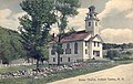
On the southwest shore of Mascoma Lake is Enfield Shaker Village, once a utopian religious community of Shakers, renowned for simple and functional architecture and furniture. Established in 1793 and called "Chosen Vale", the village was subdivided into several "Families", with men and women leading pious, celibate and industrious lives. Although the genders shared dormitories, like Enfield's Great Stone Dwelling built between 1837 and 1841, the sexes used separate doors and stairways. They practiced ecstatic singing and dancing, an expression of their worship, which earned them the appellation of Shaking Quakers, or Shakers.

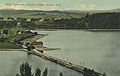
Several trades operated at the village, from agriculture and packaging of seeds, to the manufacture of brooms, brushes, spinning-wheels, and furniture. To speed delivery of products to the railroad across Mascoma Lake, in 1849 the community erected Shaker Bridge.

The Shaker movement crested in the 1840s, with 19 "societies" scattered from Maine to Kentucky and west to Indiana. But growing employment opportunities created by the Industrial Revolution, as near as the mill town of Lebanon, enticed away potential and practicing church members. Others grew disaffected with celibacy, self-abnegation, and communal ownership of property. Indeed, Mary Marshall Dyer, once a member of the Enfield church, became an outspoken Anti-Shaker. Eventually the village would close and, in 1927, be sold to the La Salette Brotherhood of Montreal, a Catholic order noted for its Christmas display. In 1986, Enfield Shaker Village was established as a museum on part of the historic property. The museum steadily expanded its footprint by purchases of key Shaker properties, culminating in the acquisition of all the remaining La Salette buildings and land in September 2023 when the Catholic order left Enfield.

Geography

According to the United States Census Bureau, the town has a total area of 43.2 square miles (111.8 km2), of which 40.3 square miles (104.4 km2) are land and 2.9 square miles (7.4 km2) are water, comprising 6.60% of the town. [1] Enfield is drained by the Mascoma River, a west-flowing tributary of the Connecticut River. Mascoma Lake, in the west, represents Enfield's lowest elevation at 751 feet (229 m) above sea level. The highest elevation is over 2,100 ft (640 m) at the summit of Prospect Hill, overlooking Halfmile Pond. Crystal Lake is in the east. The town lies fully within the Connecticut River watershed. [5]

Enfield is served by Interstate 89, U.S. Route 4, New Hampshire Route 4A and New Hampshire Route 10.

Demographics

Historical population
CensusPop.Note
1790 724
1800 1,12154.8%
1810 1,29115.2%
1820 1,3706.1%
1830 1,4928.9%
1840 1,5141.5%
1850 1,74215.1%
1860 1,8767.7%
1870 1,662−11.4%
1880 1,6801.1%
1890 1,439−14.3%
1900 1,84528.2%
1910 1,448−21.5%
1920 1,5778.9%
1930 1,325−16.0%
1940 1,69327.8%
1950 1,612−4.8%
1960 1,86715.8%
1970 2,34525.6%
1980 3,17535.4%
1990 3,97925.3%
2000 4,61816.1%
2010 4,582−0.8%
2020 4,465−2.6%
U.S. Decennial Census [2] [6]

As of the census of 2010, there were 4,582 people, 2,044 households, and 1,305 families residing in the town. The population density was 113.7 persons per square mile (43.9/km2). There were 2,508 housing units at an average density of 24.0/km2 (62.2/sq mi). The racial makeup of the town was 96.8% white, 0.4% African American, 0.3% Native American or Alaska Native, 0.9% Asian, 0.0% Pacific Islander, 0.2% some other race, and 1.4% from two or more races. 1.2% of the population were Hispanic or Latino of any race. [7]

There were 2,044 households, out of which 24.1% had children under the age of 18 living with them, 50.1% were headed by married couples living together, 8.9% had a female householder with no husband present, and 36.2% were non-families. 27.7% of all households were made up of individuals, and 7.0% were someone living alone who was 65 years of age or older. The average household size was 2.24, and the average family size was 2.70. [7]

In the town, the population was spread out, with 19.4% under the age of 18, 6.1% from 18 to 24, 26.8% from 25 to 44, 33.8% from 45 to 64, and 13.9% who were 65 years of age or older. The median age was 43.6 years. For every 100 females, there were 94.6 males. For every 100 females age 18 and over, there were 93.1 males. [7]

For the period 2009–2013, the estimated median annual income for a household in the town was $80,038, and the median income for a family was $89,362. Male full-time workers had a median income of $53,061 versus $43,456 for females. The per capita income for the town was $45,653. 3.1% of the population and 1.2% of families were below the poverty line. 2.3% of people under the age of 18 and 2.2% of people 65 or older were living in poverty. [8]

Sites of interest

Notable people

Related Research Articles

<span class="mw-page-title-main">Lincoln, New Hampshire</span> Town in New Hampshire, United States

Lincoln is a town in Grafton County, New Hampshire, United States. It is the second-largest town by area in New Hampshire. The population was 1,631 at the 2020 census. The town is home to the New Hampshire Highland Games and to a portion of Franconia Notch State Park. Set in the White Mountains, large portions of the town are within the White Mountain National Forest. The Appalachian Trail crosses the western and northeastern parts of the town. Lincoln is the location of Loon Mountain Ski Resort and associated recreation-centered development.

<span class="mw-page-title-main">Grafton County, New Hampshire</span> County in New Hampshire, United States

Grafton County is a county in the U.S. state of New Hampshire. As of the 2020 census, the population was 91,118. Its county seat is North Haverhill, a village within the town of Haverhill. Until 1972, the county courthouse and other offices were in downtown Woodsville, a larger village within the town of Haverhill.

<span class="mw-page-title-main">New Gloucester, Maine</span> Town in the state of Maine, United States

New Gloucester is a town in Cumberland County, Maine, United States. It is home to the Sabbathday Lake Shaker Village, the last active Shaker village in the U.S. The town's population was 5,676 at the 2020 census.

<span class="mw-page-title-main">Wakefield, New Hampshire</span> Town in New Hampshire, United States

Wakefield is a town in Carroll County, New Hampshire, United States. The population was 5,201 at the 2020 census. The town includes the villages of Wakefield Corner, East Wakefield, North Wakefield, Sanbornville, Union, Woodman and Province Lake. Wakefield Corner, popular with tourists, is a picturesque hilltop village of antique buildings. The state of Maine is on the eastern border of Wakefield.

<span class="mw-page-title-main">Alexandria, New Hampshire</span> Town in New Hampshire, United States

Alexandria is a town in Grafton County, New Hampshire, United States. The population was 1,776 at the 2020 census, up from 1,613 at the 2010 census. Newfound Lake is in the northeast corner, with Wellington State Park on the western shore. The town is home to Welton Falls State Forest. Cardigan Mountain State Park, with Mount Cardigan, is in the west. Another attraction is Mowglis Mountain, named for Rudyard Kipling's Jungle Book hero.

<span class="mw-page-title-main">Ashland, New Hampshire</span> Town in New Hampshire, United States

Ashland is a town in Grafton County, New Hampshire, United States. The population was 1,938 at the 2020 census, down from 2,076 at the 2010 census. Located near the geographical center of the state, Ashland is home to Scribner-Fellows State Forest.

<span class="mw-page-title-main">Benton, New Hampshire</span> Town in New Hampshire, United States

Benton is a town in Grafton County, New Hampshire, United States. The population was 374 at the 2020 census. Located in the White Mountains, Benton is largely surrounded by the White Mountain National Forest. The town is crossed by the Appalachian Trail.

<span class="mw-page-title-main">Campton, New Hampshire</span> Town in New Hampshire, United States

Campton is a town in Grafton County, New Hampshire, United States. The population was 3,343 at the 2020 census. Campton, which includes the villages of Blair, Campton Hollow, Lower Campton and West Campton, is home to Blair State Forest and Livermore Falls State Forest. It is located in the foothills of the White Mountains, and parts of the White Mountain National Forest are in the northeast and northwest.

<span class="mw-page-title-main">Canaan, New Hampshire</span> Town in New Hampshire, United States

Canaan is a town in Grafton County, New Hampshire, United States. The population was 3,794 at the 2020 census. It is the location of Mascoma State Forest. Canaan is home to the Cardigan Mountain School, the town's largest employer.

<span class="mw-page-title-main">Dorchester, New Hampshire</span> Town in New Hampshire, United States

Dorchester is a town in Grafton County, New Hampshire, United States. The population was 339 at the 2020 census.

<span class="mw-page-title-main">Grafton, New Hampshire</span> Town in New Hampshire, United States

Grafton is a town in Grafton County, New Hampshire, United States. The population was 1,385 at the 2020 census.

<span class="mw-page-title-main">Groton, New Hampshire</span> Town in New Hampshire, United States

Groton is a town in Grafton County, New Hampshire, United States. The population was 569 at the 2020 census.

<span class="mw-page-title-main">Hebron, New Hampshire</span> Town in New Hampshire, United States

Hebron is a town in Grafton County, New Hampshire, United States. The population was 632 at the 2020 census. Settlements include the town center and the village of East Hebron.

<span class="mw-page-title-main">Orange, New Hampshire</span> Town in New Hampshire, United States

Orange is a town in Grafton County, New Hampshire, United States. The population was 277 at the 2020 census, down from 331 at the 2010 census.

<span class="mw-page-title-main">Rumney, New Hampshire</span> Town in New Hampshire, United States

Rumney is a town in Grafton County, New Hampshire, United States. The population was 1,498 at the 2020 census. The town is located at the southern edge of the White Mountain National Forest.

<span class="mw-page-title-main">Woodstock, New Hampshire</span> Town in New Hampshire, United States

Woodstock is a town in Grafton County, New Hampshire, United States. The population was 1,434 at the 2020 census. Woodstock includes the village of North Woodstock, the commercial center. Its extensive land area is largely forested, and includes the Hubbard Brook Experimental Forest. Parts of the White Mountain National Forest are in the east and west. The Appalachian Trail crosses the town's northwest corner. Russell Pond Campground is in the east. West of North Woodstock is the Lost River Reservation.

<span class="mw-page-title-main">Plainfield, New Hampshire</span> Place in New Hampshire, United States

Plainfield is a town in Sullivan County, New Hampshire, United States. At the time of the 2020 census, the town had a population of 2,459. The town is home to the Helen Woodruff Smith Bird Sanctuary and Annie Duncan State Forest.

<span class="mw-page-title-main">Bristol, New Hampshire</span> Town in New Hampshire, United States

Bristol is a town in Grafton County, New Hampshire, United States. The population was 3,244 at the 2020 census. It is home to Wellington State Park, Sugar Hill State Forest, and Profile Falls on the Smith River. Surrounded by hills and lakes, Bristol includes the lower two-thirds of Newfound Lake, a resort area.

Enfield is a census-designated place (CDP) and the main village in the town of Enfield in Grafton County, New Hampshire, United States. The population of the CDP was 1,571 at the 2020 census, out of 4,465 in the entire town.

<span class="mw-page-title-main">Enfield Shaker Museum</span> United States historic place

The Enfield Shaker Museum is an outdoor history museum and historic district in Enfield, New Hampshire, in the United States. It is dedicated to preserving and sharing the history of the Shakers, a Protestant religious denomination, who lived on the site from 1793 to 1923. The museum features exhibitions, artifacts, eight Shaker buildings and restored Shaker gardens. It is located in a valley between Mount Assurance and Mascoma Lake in Enfield.

References

  1. 1 2 "2021 U.S. Gazetteer Files – New Hampshire". United States Census Bureau. Retrieved November 23, 2021.
  2. 1 2 3 "Enfield town, Grafton County, New Hampshire: 2020 DEC Redistricting Data (PL 94-171)". U.S. Census Bureau. Retrieved November 23, 2021.
  3. Coolidge, Austin J.; John B. Mansfield (1859). A History and Description of New England. Boston, Massachusetts: A.J. Coolidge. pp.  484–485. coolidge mansfield history description new england 1859.
  4. "New Hampshire Search Roots". History of Enfield, Grafton County, New Hampshire. Retrieved January 2, 2007.
  5. Foster, Debra H.; Batorfalvy, Tatianna N.; Medalie, Laura (1995). Water Use in New Hampshire: An Activities Guide for Teachers. U.S. Department of the Interior and U.S. Geological Survey.
  6. "Census of Population and Housing". Census.gov. Retrieved June 4, 2016.
  7. 1 2 3 "Profile of General Population and Housing Characteristics: 2010 Census Summary File 1 (DP-1): Enfield town, Grafton County, New Hampshire". U.S. Census Bureau, American Factfinder. Archived from the original on April 15, 2015. Retrieved April 15, 2015.
  8. "Selected Economic Characteristics: 2010 Census Summary File 1 (DP03): Enfield town, Grafton County, New Hampshire". U.S. Census Bureau, American Factfinder. Archived from the original on April 15, 2015. Retrieved April 15, 2015.