Montcalm, New Hampshire

Last updated
Montcalm, New Hampshire
MontcalmNH.jpg
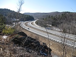
Exit 15 (Montcalm) on Interstate 89
USA New Hampshire location map.svg
Red pog.svg
Montcalm
Usa edcp location map.svg
Red pog.svg
Montcalm
Coordinates: 43°35′50″N72°10′00″W / 43.59722°N 72.16667°W / 43.59722; -72.16667 Coordinates: 43°35′50″N72°10′00″W / 43.59722°N 72.16667°W / 43.59722; -72.16667
Country United States
State New Hampshire
County Grafton
Town Enfield
Elevation
1,211 ft (369 m)
Time zone UTC-5 (Eastern (EST))
  Summer (DST) UTC-4 (EDT)
Area code(s) 603
GNIS feature ID1917586 [1]

Montcalm is an unincorporated community in the town of Enfield in Grafton County, New Hampshire, United States. [2] It is located along a portion of old New Hampshire Route 10 that remains after most of the road was replaced by Interstate 89. The stretch of old road is only accessible from Exit 15 on I-89; in both directions from the exit the old road reaches a dead end. (Present-day Route 10 follows Interstate 89 in a concurrency through this area.) The elevation is 1,211 feet (369 m) above sea level. [3]

The name "Montcalm" was chosen by Enfield's selectmen in 1960 when the construction of I-89 was in the planning stages, to replace the name "South Notch" that had been proposed by state highway engineers. Montcalm had once been the name of a settlement in the area which had had its own post office and school. [4]

Related Research Articles

Interstate 91 (I-91) is an Interstate Highway in the New England region of the United States. It provides the primary north–south thoroughfare in the western part of the region. The Interstate generally follows the course of the Connecticut River. Its southern end is in New Haven, Connecticut, at Interstate 95. The northern end of the American-maintained road is in the village of Derby Line, Vermont, at the Canadian border. I-91 then continues past the Derby Line-Rock Island Border Crossing, where the road's official name changes to Autoroute 55. I-91 is the longest of three Interstate highways whose entire route is located within the New England states and is also the only primary (two-digit) Interstate Highway in New England to intersect all five of the others that run through the region. The largest cities along its route are New Haven, Connecticut, Hartford, Connecticut, Springfield, Massachusetts, Greenfield, Massachusetts, Brattleboro, Vermont, White River Junction, Vermont, and St. Johnsbury, Vermont in order from south to north.

Interstate 93 (I-93) is an Interstate Highway in the New England region of the United States. It begins in Canton, Massachusetts, in the Boston metropolitan area, at I-95; and ends near St. Johnsbury, Vermont, at I-91. It is one of three mainline Interstate highways located wholly within New England, the other two being I-89 and I-91. The largest cities along its route are Manchester, New Hampshire, and Boston, Massachusetts. It also passes through the New Hampshire state capital of Concord.

Interstate 89 (I-89) is an Interstate Highway in the New England region of the United States traveling from Bow, New Hampshire, to the Canadian border between Highgate Springs, Vermont, and Saint-Armand, Quebec. As with all odd-numbered primary interstates, I-89 is signed as a north–south highway. However, it follows a primarily northwest-to-southeast path. The route forms a substantial part of the main connection between the cities of Montreal and Boston. In Quebec the route continues as Quebec Route 133. The eventual completion of Autoroute 35 from Montreal will lead to a non-stop limited access highway route between the two cities, following I-93 south from I-89's terminus. The largest cities directly served by I-89 are Concord, the state capital of New Hampshire, Montpelier, the state capital of Vermont, and Burlington, Vermont. I-89 is one of three main Interstate highways whose route is located entirely within New England, along with I-91 and I-93.

Lebanon, New Hampshire City in New Hampshire, United States

Lebanon is the only city in Grafton County, New Hampshire, United States. The population was 13,151 at the 2010 census and an estimated 13,602 as of 2018. Lebanon is in western New Hampshire, south of Hanover, near the Connecticut River. It is the home to Dartmouth–Hitchcock Medical Center and Dartmouth Medical School, together comprising the largest medical facility between Boston, Massachusetts and Burlington, Vermont.

Pelham, New Hampshire Town in New Hampshire, United States

Pelham is a town in Hillsborough County, New Hampshire, United States. The population was 12,897 at the 2010 census, and in 2017 the estimated population was 13,681.

New London, New Hampshire Town in New Hampshire, United States

New London is a town in Merrimack County, New Hampshire, United States. The population was 4,397 at the 2010 census. The town is the home of Colby–Sawyer College.

White Pine, Tennessee Town in Tennessee, United States

White Pine is a town in Jefferson county in the U.S. state of Tennessee. It is part of the Morristown, Tennessee Metropolitan Statistical Area. The population was 2,196 at the 2010 census.

Enfield (CDP), New Hampshire Census-designated place in New Hampshire, United States

Enfield is a census-designated place (CDP) and the main village in the town of Enfield in Grafton County, New Hampshire, United States. The population of the CDP was 1,540 at the 2010 census, out of 4,582 people in the entire town of Enfield.

Enfield, New Hampshire Town in New Hampshire, United States

Enfield is a town in Grafton County, New Hampshire, United States. The population was 4,582 at the 2010 census. The town includes the villages of Enfield, Enfield Center, Upper Shaker Village, Lower Shaker Village, Lockehaven, and Montcalm.

U.S. Route 5 highway in the United States

U.S. Route 5 is a north–south United States highway running through the New England states of Connecticut, Massachusetts, and Vermont. Significant cities along the route include New Haven, Connecticut; Hartford, Connecticut; and Springfield, Massachusetts. From Hartford northward to St. Johnsbury, Vermont, the road closely follows the route of the Connecticut River.

The Falmouth Spur is a short freeway connecting Interstate 95 (I-95) with I-295 and U.S. Route 1 (US 1) north of Portland, Maine, in the United States. It carries the unsigned designation of I-495. As part of the Maine Turnpike, the mainline of which carries I-95, the Falmouth Spur is a toll road. The spur has only two interchanges—one at each end—and a toll booth in the middle. It is signed only for its destinations—I-95, I-295 and US 1—to minimize driver confusion.

New Hampshire Route 10 highway in New Hampshire

New Hampshire Route 10 is a 122.25-mile-long (196.74 km) north–south state highway in western New Hampshire, United States. Its southern terminus is in Winchester at the Massachusetts state line, where it continues south as Massachusetts Route 10. Administratively, the northern terminus is at a junction with U.S. Route 302 in Haverhill.

The New Hampshire Highway System is the public roads system of the U.S. state of New Hampshire containing approximately 17,029 miles (27,406 km) maintained by the New Hampshire Department of Transportation (NHDOT). All public roads in the state are called "highways", thus there is no technical distinction between a "road" or a "highway" in New Hampshire.

Interstate 95 (I-95) in the US state of Maine is a 303-mile-long (488 km) highway running from the New Hampshire state line in Kittery, to the Canadian border in Houlton. It is the only two-digit Interstate Highway in Maine. In 2004, the highway's route between Portland and Gardiner was changed so that it encompasses the entire Maine Turnpike, a toll road running from Kittery to Augusta.

Interstate 10 (I-10) in the US state of New Mexico is a 164.264-mile (264.357 km) long route of the United States Interstate Highway System. I-10 traverses southern New Mexico through Hidalgo, Grant, Luna, and Doña Ana counties. The Interstate travels west–east from the Arizona state line to the interchange with I-25 in Las Cruces, and then travels north–south to the Texas state line. US Route 80 in New Mexico (US 80) was replaced by Interstate 10.

In the United States, exit numbers are assigned to freeway junctions, and are usually numbered as exits from freeways. Exit numbers generally are found above the destinations of the exit, as well as a sign in the gore. Exit numbers typically reset at political borders such as state lines. Some major streets also use exit numbers. Freeway exits in the United States are usually numbered in two formats: distance-based and sequential.

U.S. Route 5 in Connecticut section of U.S. Highway in Connecticut, United States

U.S. Route 5 (US 5), a north–south U.S. Highway that is generally paralleled by Interstate 91 (I-91), begins at the city of New Haven in Connecticut and heads north through western Massachusetts and eastern Vermont to the international border with Canada. Within Connecticut, US 5 proceeds north from New Haven and passes through Meriden and Hartford towards Springfield, Massachusetts.

North Sutton, New Hampshire Unincorporated community in New Hampshire, United States

North Sutton is an unincorporated community in the town of Sutton in Merrimack County, New Hampshire. It is located at the eastern end of Kezar Lake, adjacent to Wadleigh State Park.

Georges Mills, New Hampshire Unincorporated community in New Hampshire, United States

Georges Mills is an unincorporated community in the town of Sunapee in Sullivan County, New Hampshire, in the United States. It is located in the northeast corner of the town, on a strip of land between the north end of Lake Sunapee and the south shore of Otter Pond. New Hampshire Route 11 runs through the village, leading east to New London and south to the center of Sunapee. It is also served by exit 12A on Interstate 89, 0.5 miles (0.8 km) north of the village.

U.S. Route 4 in New Hampshire highway in New Hampshire

U.S. Route 4 in the state of New Hampshire runs for 106.8 miles (171.9 km) across the central and southern part of the state, stretching from Lebanon on the Connecticut River border with Vermont southeast to Portsmouth on the eastern coast.

References

  1. "Montcalm". Geographic Names Information System . United States Geological Survey.
  2. "Montcalm, New Hampshire". HometownLocator.com. Retrieved August 15, 2011.
  3. U.S. Geological Survey 7.5 x 15 minute topographic map series: North Grantham quadrangle
  4. Janice Aitkin, "The towns that can't be found: Exits say Purmort and Montcalm -- but where are they?", The Nashua Telegraph, 5/22/82 p. 2