East Lyme is a town in New London County, Connecticut, United States. The population was 19,159 at the 2010 census. The villages of Niantic and Flanders are located in the town.

Lyme is a town in New London County, Connecticut, United States. The population was 2,406 at the 2010 census. Lyme and its neighboring town Old Lyme are the namesake for Lyme disease.

Old Lyme is a coastal town in New London County, Connecticut, United States. The Main Street of the town, Lyme Street, is a historic district. The town has long been a popular summer resort and artists' colony. The town is named after Lyme Regis, England.

Orford is a town in Grafton County, New Hampshire, United States. The population was 1,237 at the 2010 census. The Appalachian Trail crosses in the east.
Canterbury is a town in Merrimack County, New Hampshire, United States. The population was 2,352 at the 2010 census. The Canterbury Shaker Village is in the eastern part of the town.

Hopkinton is a town in Merrimack County, New Hampshire, United States. The population was 5,589 at the 2010 census. The town has three distinct communities: Hopkinton village, mainly a residential area in the center of the town; Contoocook, the town's business hub, located in the north; and West Hopkinton, within the more agricultural portion of the town. The town is home to the Hopkinton State Fair, adjacent to Contoocook village, and to the historic Contoocook Railroad Depot and the Contoocook Railroad Bridge, the oldest covered railroad bridge in the United States.

Newbury is a town in Merrimack County, New Hampshire, United States. The population was 2,072 at the 2010 census. Newbury is home to part of Lake Sunapee, including Mount Sunapee State Park Beach. Mount Sunapee Resort, a ski area in Mount Sunapee State Park, is in the west. The town includes the villages of Blodgett Landing and South Newbury.

Lyme is a town in Jefferson County, New York, United States. The population was 2,185 at the 2010 census.

Derry is a town in Rockingham County, New Hampshire, United States. The population was 33,109 at the 2010 census. Although it is a town and not a city, Derry is the fourth most-populous community in the state. The town's nickname, "Spacetown", derives from the fact that Derry is the birthplace of Alan Shepard, the first astronaut from the United States in space. Derry was also for a time the home of the poet Robert Frost and his family.

Hillsborough, frequently spelled Hillsboro, is a town in Hillsborough County, New Hampshire, United States. The population was 6,011 at the 2010 census. The town is home to Fox State Forest and part of Low State Forest.
Blow-me-down Brook is a 12.8-mile (20.6 km) long stream located in western New Hampshire in the United States. It is a tributary of the Connecticut River, which flows to Long Island Sound.

North Haverhill is an unincorporated community and census-designated place (CDP) in the town of Haverhill in Grafton County, New Hampshire, United States. It is one of several villages in the town of Haverhill, which is the county seat of Grafton County.

East Derry, also known as the Upper Village, is an unincorporated community in the town of Derry in Rockingham County, New Hampshire. The village center constitutes the East Derry Historic District, listed on the National Register of Historic Places. It is located on a hill close to the geographic center of the town of Derry along East Derry Road, approximately 2 miles (3 km) east of the built-up town center of Derry. East Derry has a separate ZIP code (03041) from the rest of the town of Derry. Alan Shepard lived in the village as a boy. Station #4 of the Derry Fire Department is located in the village.

Vermont Route 113 is a state highway in eastern Vermont in the United States. It runs south and east from an intersection with Vermont Route 110 in Chelsea to the New Hampshire border in Thetford. VT 113 crosses the Connecticut River, becoming East Thetford Road, an unnumbered local road in the town of Lyme, New Hampshire which connects to New Hampshire Route 10.

Moose Mountain is an 8-mile (13 km)-long ridge located in the eastern part of the town of Hanover in Grafton County, New Hampshire. The mountain is flanked to the north by Holts Ledge, at 2,110 feet (640 m), and to the south by Shaker Mountain, at 1,690 feet (520 m). It is traversed by the Appalachian Trail, a 2,170-mile (3,490 km) National Scenic Trail from Georgia to Maine. Moose Mountain is outside the White Mountain National Forest, but the trail runs through a narrow corridor along the ridge which is administered by the U.S. Forest Service. The trail can be accessed from the south along Three Mile Road in Hanover, and from the north along Goose Pond Road in Lyme, New Hampshire.

East Andover is an unincorporated community in the town of Andover in Merrimack County, New Hampshire. The center of the community forms the East Andover Village Center Historic District.

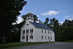
The Lyme Center Historic District encompasses a modest crossroads and industrial village in rural Lyme, New Hampshire. The predominantly residential district stretches along Dorchester Road, on either side of its junction with Baker Hill Road. The village's rise in development started in the early 19th century as it was at a crossroads of the east-west Dorchester Road, and the north-south Baker Hill Road and Acorn Hill Road. The village grew rapidly in the 1820s, with a number of simple Greek Revival houses, and in 1830 the Baptist Church was built. The other major civic building in the village is the Lyme Academy, built in 1839, albeit with more Federal than Greek Revival styling. Grant Brook, which runs parallel to Dorchester Road, provided a source of power for the growth of small industrial efforts, including a sawmill at the corner of Dorchester and Baker Hill Roads. This industry provided a second minor building boom in the late 19th to early 20th century. Most of the houses in the district are vernacular Greek Revival or Cape in their styling; probably the most elaborate Greek Revival house is the 1857 Beal-Pike House at 41 Dorchester Road.

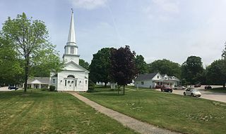
The Lyme Common Historic District encompasses the original historic center of Lyme, New Hampshire. Established in 1781, it includes sixty historic buildings surrounding the town common and along surrounding roads, and is a well-preserved example of a 19th-century village center. The district was listed on the National Register of Historic Places in 1988.