Bethlehem (CDP), New Hampshire

Last updated

Bethlehem, New Hampshire
Bethlehem CDP NH March 2024.jpg
Center of Bethlehem, March 2024
USA New Hampshire location map.svg
Red pog.svg
Bethlehem
Usa edcp location map.svg
Red pog.svg
Bethlehem
Coordinates: 44°16′49″N71°41′15″W / 44.28028°N 71.68750°W / 44.28028; -71.68750
Country United States
State New Hampshire
County Grafton
Town Bethlehem
Area
[1]
  Total1.64 sq mi (4.24 km2)
  Land1.63 sq mi (4.23 km2)
  Water0.00 sq mi (0.01 km2)
Elevation
1,426.5 ft (434.8 m)
Population
 (2020)
  Total826
  Density505.51/sq mi (195.15/km2)
Time zone UTC-5 (Eastern (EST))
  Summer (DST) UTC-4 (EDT)
ZIP code
03574
Area code 603
FIPS code 33-05380
GNIS feature ID2629715

Bethlehem is a census-designated place (CDP) and the main village in the town of Bethlehem in Grafton County, New Hampshire, United States. The population of the CDP was 826 at the 2020 census, [2] out of 2,484 in the entire town.

Contents

Geography

The CDP is in the western part of the town of Bethlehem, along U.S. Route 302 at the northern base of 2,370-foot (722.3 m) Mount Agassiz. US 302 leads east 8 miles (13 km) to Twin Mountain and west 5 miles (8 km) to Littleton. New Hampshire Route 142 crosses US 302 in the center of town, leading north 8 miles (13 km) to Whitefield and south 6 miles (10 km) to Franconia village.

From the center of the village, the CDP reaches west along US 302 as far as Valley View Lane, south along NH 142 to Mountain View Lane, east on US 302 past Turner Street and Ivie Lane, and north from NH 142 down Barrett Brook, nearly to Prospect Road. [3]

According to the U.S. Census Bureau, the Bethlehem CDP has a total area of 1.6 square miles (4.2 km2), of which 2.3 acres (9,255 m2), or 0.22%, are water. [4]

Demographics

Historical population
CensusPop.Note
2010 972
2020 826−15.0%
U.S. Decennial Census [5]

As of the census of 2010, there were 972 people, 424 households, and 257 families residing in the CDP. There were 531 housing units, of which 107, or 20.2%, were vacant. 57 of the vacant units were for seasonal use. The racial makeup of the town was 97.8% white, 0.1% African American, 0.6% Native American, 0.2% Asian, 0.0% Pacific Islander, 0.2% some other race, and 1.0% from two or more races. 2.9% of the population were Hispanic or Latino of any race. [6]

Of the 424 households in the CDP, 33.5% had children under the age of 18 living with them, 43.9% were headed by married couples living together, 13.4% had a female householder with no husband present, and 39.4% were non-families. 33.3% of all households were made up of individuals, and 8.0% were someone living alone who was 65 years of age or older. The average household size was 2.29, and the average family size was 2.91. [6]

25.6% of people in the CDP were under the age of 18, 7.6% were from age 18 to 24, 23.5% were from 25 to 44, 33.7% were from 45 to 64, and 9.6% were 65 years of age or older. The median age was 39.8 years. For every 100 females, there were 96.8 males. For every 100 females age 18 and over, there were 90.8 males. [6]

For the period 2011-15, the estimated median annual income for a household was $47,941, and the median income for a family was $62,500. Male full-time workers had a median income of $36,000 versus $42,875 for females. The per capita income for the CDP was $22,146. 30.0% of the population and 20.5% of families were below the poverty line, along with 38.9% of people under the age of 18 and 25.0% of people 65 or older. [7]

Related Research Articles

<span class="mw-page-title-main">Bethlehem, New Hampshire</span> Town in New Hampshire, United States

Bethlehem is a hillside town in Grafton County, New Hampshire, United States. The population was 2,484 at the 2020 census. It is home to Cushman and Strawberry Hill state forests. The eastern half of the town is within the White Mountain National Forest. The Appalachian Trail crosses a small portion of the town in the south.

<span class="mw-page-title-main">Meredith (CDP), New Hampshire</span> Census-designated place in New Hampshire, United States

Meredith is a census-designated place (CDP) and the main village in the town of Meredith in Belknap County, New Hampshire, United States. The population was 2,527 at the 2020 census, out of 6,662 in the entire town of Meredith.

<span class="mw-page-title-main">Jaffrey (CDP), New Hampshire</span> Census-designated place in New Hampshire, United States

Jaffrey is a census-designated place (CDP) and the main village in the town of Jaffrey in Cheshire County, New Hampshire, United States. The population of the CDP was 3,058 at the 2020 census, out of 5,320 in the entire town of Jaffrey.

Whitefield is a census-designated place (CDP) and the main village in the town of Whitefield in Coos County, New Hampshire, United States. The population of the CDP was 1,460 at the 2020 census, out of 2,490 people in the entire town of Whitefield.

<span class="mw-page-title-main">Bristol (CDP), New Hampshire</span> Census-designated place in New Hampshire, United States

Bristol is a census-designated place (CDP) and the main village in the town of Bristol in Grafton County, New Hampshire, United States. The population of the CDP was 1,911 at the 2020 census, out of 3,244 in the entire town.

Littleton is a census-designated place (CDP) and the main village in the town of Littleton in Grafton County, New Hampshire, United States. The population of the CDP was 4,467 at the 2020 census, out of 6,005 in the entire town.

<span class="mw-page-title-main">Plymouth (CDP), New Hampshire</span> Census-designated place in New Hampshire, United States

Plymouth is a census-designated place (CDP) and the main village in the town of Plymouth in Grafton County, New Hampshire, United States. Its population was 4,730 at the 2020 census, out of 6,682 in the entire town. The CDP includes the campus of Plymouth State University.

<span class="mw-page-title-main">Hillsborough (CDP), New Hampshire</span> Census-designated place in New Hampshire, United States

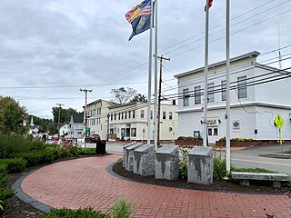
Hillsborough is a census-designated place (CDP) and the main village in the town of Hillsborough in Hillsborough County, New Hampshire, United States. The population of the CDP was 2,156 at the 2020 census, out of 5,939 in the entire town.

<span class="mw-page-title-main">Peterborough (CDP), New Hampshire</span> Census-designated place in New Hampshire, United States

Peterborough is a census-designated place (CDP) and the main village in the town of Peterborough, Hillsborough County, New Hampshire, United States. The population of the CDP was 3,090 at the 2020 census, out of 6,418 in the entire town.

<span class="mw-page-title-main">Hooksett (CDP), New Hampshire</span> Census-designated place in New Hampshire, United States

Hooksett is a census-designated place (CDP) in the town of Hooksett in Merrimack County, New Hampshire, United States. The CDP includes the historic central village of Hooksett as well as suburban and rural land surrounding it. The population of the CDP was 5,283 at the 2020 census, out of 14,871 in the entire town.

<span class="mw-page-title-main">Epping (CDP), New Hampshire</span> Census-designated place in New Hampshire, United States

Epping is a census-designated place (CDP) and the main village in the town of Epping, Rockingham County, New Hampshire, United States. The population of the CDP was 2,693 at the 2020 census, out of 7,125 in the entire town.

<span class="mw-page-title-main">Hampton (CDP), New Hampshire</span> Census-designated place in New Hampshire, United States

Hampton is a census-designated place (CDP) comprising the town center and surrounding developed areas of the town of Hampton, Rockingham County, New Hampshire, United States. The population of the CDP was 9,597 at the 2020 census, out of 16,214 in the entire town.

<span class="mw-page-title-main">North Woodstock, New Hampshire</span> Census-designated place in New Hampshire, United States

North Woodstock is a census-designated place (CDP) and the primary village in the town of Woodstock in Grafton County, New Hampshire, United States. It had a population of 739 at the 2020 census.

<span class="mw-page-title-main">Bartlett (CDP), New Hampshire</span> Census-designated place in New Hampshire, United States

Bartlett is a census-designated place (CDP) and the main village in the town of Bartlett in Carroll County, New Hampshire, United States. The population was 351 at the 2020 census, out of 3,200 in the entire town of Bartlett.

<span class="mw-page-title-main">Belmont (CDP), New Hampshire</span> Census-designated place in New Hampshire, United States

Belmont is a census-designated place (CDP) and the main village in the town of Belmont in Belknap County, New Hampshire, United States. The population was 1,285 at the 2020 census, out of 7,314 in the entire town of Belmont.

<span class="mw-page-title-main">Goffstown (CDP), New Hampshire</span> Census-designated place in New Hampshire, United States

Goffstown is a census-designated place (CDP) and the main village in the town of Goffstown in Hillsborough County, New Hampshire, United States. The population of the CDP was 3,366 at the 2020 census, out of 18,577 in the entire town.

New Hampton is a census-designated place (CDP) and the main village in the town of New Hampton in Belknap County, New Hampshire, United States. The population was 373 at the 2020 census, out of 2,377 people in the entire town of New Hampton.

<span class="mw-page-title-main">Ashland (CDP), New Hampshire</span> Census-designated place in New Hampshire, United States

Ashland is a census-designated place (CDP) and the main village in the town of Ashland in Grafton County, New Hampshire, United States. The population of the CDP was 1,082 at the 2020 census, out of 1,938 in the entire town.

<span class="mw-page-title-main">Bennington (CDP), New Hampshire</span> Census-designated place in New Hampshire, United States

Bennington is a census-designated place (CDP) and the main village in the town of Bennington in Hillsborough County, New Hampshire, United States. The population of the CDP was 338 at the 2020 census, out of 1,501 in the entire town.

<span class="mw-page-title-main">Colebrook (CDP), New Hampshire</span> Census-designated place in New Hampshire, United States

Colebrook is a census-designated place (CDP) and the main village in the town of Colebrook, Coös County, New Hampshire, United States. The population of the CDP was 1,201 at the 2020 census, out of 2,084 in the entire town. The CDP population had dropped from 1,394 at the 2010 census.

References

  1. "ArcGIS REST Services Directory". United States Census Bureau. Retrieved September 20, 2022.
  2. "Bethlehem CDP, New Hampshire: 2020 DEC Redistricting Data (PL 94-171)". U.S. Census Bureau. Retrieved December 1, 2021.
  3. "TIGERweb: Bethlehem CDP, New Hampshire". Geography Division, U.S. Census Bureau. Retrieved August 30, 2017.
  4. "2021 U.S. Gazetteer Files – New Hampshire". United States Census Bureau. Retrieved December 1, 2021.
  5. "Decennial Census Official Publications". Census.gov. Retrieved March 4, 2024.
  6. 1 2 3 "Profile of General Population and Housing Characteristics: 2010 Census Summary File 1 (DP-1): Bethlehem CDP, New Hampshire". U.S. Census Bureau, American Factfinder. Archived from the original on February 13, 2020. Retrieved August 30, 2017.
  7. "Selected Economic Characteristics: 2011-2015 American Community Survey 5-Year Estimates (DP03): Bethlehem CDP, New Hampshire". U.S. Census Bureau, American Factfinder. Archived from the original on February 13, 2020. Retrieved August 30, 2017.