York Beach, Maine

Last updated
York Beach, Maine
Area within New England town
USA Maine location map.svg
Red pog.svg
York Beach
Location within the state of Maine
Coordinates: 43°10′31″N70°36′38″W / 43.17528°N 70.61056°W / 43.17528; -70.61056
Country United States
State Maine
County York
Elevation
20 ft (6 m)
Time zone UTC-5 (Eastern (EST))
  Summer (DST) UTC-4 (EDT)
ZIP code
03910 [1]

York Beach is a community within the town of York, Maine, United States. The York Beach area consists of Long Sands and Short Sands beaches on the Atlantic Ocean in the Gulf of Maine. The two beaches are separated by Cape Neddick. Cape Neddick and York Beach together comprise the Cape Neddick census-designated place, with a year-round population of 2,568. [2] The town of York consists of the communities of York Beach, Cape Neddick, York Harbour, and the village of York. The town is home to 12,529 residents, though rising to an estimated 52,000 during the summer months. [3]

Contents

Beaches

There are two main beaches which make up the York Beach area.

Long Sands Beach Long Sands Beach at York Beach IMG 1953 FRD.jpg
Long Sands Beach

Long Sands Beach: Long Sands Beach extends for 1.3 miles (2.1 km).

Short Sands Beach Short Sands Beach at York Beach IMG 1978 FRD.jpg
Short Sands Beach

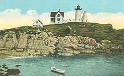
Short Sands Beach: Located on the north side of Cape Neddick, Short Sands Beach is home of Cape Neddick Light, locally known as "Nubble Light." The much shorter of the two beaches, with a more densely developed downtown area with several historical and commercial properties. The area has many arcades, shops, restaurants, and nightlife. [4]

Special events

York Days is an annual event that takes place around the downtown York Beach area. York Days takes place on a weekend in early August every year. Events include a craft fair, a softball tournament, and a large fireworks display on the last Sunday of the weekend. [5]

Lighting of the Nubble: The Nubble Light is lit up twice a year with Christmas lights. The first time is known as "Christmas in July," and takes place around July 25 every year. The second is the "Annual Lighting of the Nubble," which takes place in December to honor the actual holiday season. [6]

Locations of interest

York Beach ~ 1901 TotallyFreeImages com-254533-Standard-preview.jpg
York Beach ~ 1901
Cape Neddick Light c. 1920 Nubble Light, York, ME.jpg
Cape Neddick Light c. 1920

Cape Neddick Light , also known as Nubble Lighthouse, is located on Short Sands Beach and stands 41 feet (12 m) tall. Construction began in 1876 and cost $15,000. It was first illuminated on July 1, 1879. The lighthouse was originally red, but was painted white in 1902, when the red keeper's house was built. The lighthouse became automated in 1987. [7]

Goldenrod was established by Edward and Mattie Talpey in 1896 at the very location where it stands today. [8]

Union Bluff Hotel: This hotel has stood on the Union Bluffs since being built in 1875 by Moses French. The area around the hotel greatly expanded due to tourism in the late 1870s, and the hotel provided an ideal lodging option for the increasing number of tourists visiting the area. The original Union Bluff Hotel was one of the oldest wooden buildings in York Beach until the original building was destroyed by fire in 1987. It was rebuilt in just two years, in 1989, and has been the same ever since. The hotel underwent multiple name changes, including: The Wahnita (c. 1900s), The York Plaza Hotel (c. 1930s), and The Union Bluff Hotel (c. 1976). [9]

Government

York Beach resides within the town of York, which has a council-manager form of government.

Related Research Articles

<span class="mw-page-title-main">Cape Cod</span> Cape in the northeastern United States

Cape Cod is an arm-shaped peninsula extending into the Atlantic Ocean from the southeastern corner of Massachusetts, in the northeastern United States. Its historic, maritime character and ample beaches attract heavy tourism during the summer months. The name Cape Cod, coined in 1602 by Bartholomew Gosnold, is the ninth oldest English place-name in the U.S.

<span class="mw-page-title-main">Cape Neddick, Maine</span> Census-designated place in Maine, United States

Cape Neddick is a census-designated place (CDP) in the town of York in York County, Maine, United States. The population was 2,568 at the 2010 census. It is part of the Portland–South Portland–Biddeford, Maine Metropolitan Statistical Area.

<span class="mw-page-title-main">Ogunquit, Maine</span> Town in Maine, United States

Ogunquit is a resort town in York County, Maine, United States. As of the 2020 census, its population was 1,577.

York is a town in York County, Maine, United States, near the southern tip of the state. The population in the 2020 census was 13,723. Situated beside the Atlantic Ocean on the Gulf of Maine, York is a well-known summer resort town. It is home to three 18-hole golf clubs, four sandy beaches, and Mount Agamenticus. From south to north, it is divided into the villages of Bald Head, York Village, York Harbor, York Beach and Cape Neddick.

<span class="mw-page-title-main">York Harbor, Maine</span> Census-designated place in Maine, United States

York Harbor is a census-designated place (CDP) in the town of York in York County, Maine, United States. The population was 3,033 at the 2010 census. York Harbor is a distinguished former Gilded Age summer colony noted for its resort architecture. It is part of the Portland–South Portland–Biddeford, Maine Metropolitan Statistical Area.

<span class="mw-page-title-main">Isles of Shoals</span> Group of small islands off the coast of New Hampshire and Maine, US

The Isles of Shoals are a group of small islands and tidal ledges situated approximately 6 miles (10 km) off the east coast of the United States, straddling the border of the states of Maine and New Hampshire.

<span class="mw-page-title-main">Kennebunkport, Maine</span> Town in the state of Maine, United States

Kennebunkport is a resort town in York County, Maine, United States. The population was 3,629 people at the 2020 census. It is part of the Portland–South Portland–Biddeford metropolitan statistical area.

<span class="mw-page-title-main">Block Island</span> Town in Rhode Island, United States

Block Island is an island of the Outer Lands coastal archipelago, located approximately 9 miles (14 km) south of mainland Rhode Island and 14 miles (23 km) east of Long Island's Montauk Point. The island is coterminous with the town of New Shoreham, Rhode Island and is part of Washington County. The island is named after Dutch explorer Adriaen Block, and the town was named for Shoreham, Kent, in England.

<span class="mw-page-title-main">Jersey Shore</span> Coastal region of the U.S. state of New Jersey

The Jersey Shore is the coastal region of the U.S. state of New Jersey. Geographically, the term encompasses about 141 miles (227 km) of oceanfront bordering the Atlantic Ocean, from Perth Amboy in the north to Cape May Point in the south. The region includes Middlesex, Monmouth, Ocean, Atlantic, and Cape May counties, which are in the central and southern parts of the state. Located in the center of the Northeast Megalopolis, the northern half of the shore region is part of the New York metropolitan area, while the southern half of the shore region is part of the Philadelphia metropolitan area, also known as the Delaware Valley. The Jersey Shore hosts the highest concentration of oceanside boardwalks in the United States.

Cape Meares is a small headland on the Pacific coast in Tillamook County, Oregon, United States. The cape forms a high steep bluff on the south end of Tillamook Bay, approximately five miles (8 km) northwest of the city of Tillamook. Much of the cape is part of the Oregon Parks and Recreation Department-administered Cape Meares State Scenic Viewpoint with three miles of hiking trails, which includes Cape Meares Light and the Octopus Tree. The cape is named after John Meares, a British explorer.

<span class="mw-page-title-main">Nobska Light</span> Lighthouse near Woods Hole, Massachusetts, US

Nobska Light, originally called Nobsque Light, also known as Nobska Point Light is a lighthouse located near the division between Buzzards Bay, Nantucket Sound, and Vineyard Sound in the settlement of Woods Hole, Massachusetts on the southwestern tip of Cape Cod, Massachusetts. It overlooks Martha's Vineyard and Nonamesset Island. The light station was established in 1828, with the tower protruding above the keeper's house, and was replaced in 1876 by the current 42 foot tall iron tower. The light station was added to the National Register of Historic Places as Nobska Point Light Station in 1987.

<span class="mw-page-title-main">Cape Neddick Light</span> Lighthouse in Maine, US

The Cape Neddick Light is a lighthouse in Cape Neddick, York, Maine. In 1874 Congress appropriated $15,000 to build a light station at the "Nubble" and in 1879 construction began. Cape Neddick Light Station was dedicated by the U.S. Lighthouse Service and put into use in 1879. It is still in use today.

<span class="mw-page-title-main">Resort town</span> Town with tourism or vacationing as a primary attraction

A resort town, resort city or resort destination is an urban area where tourism or vacationing is the primary component of the local culture and economy. A typical resort town has one or more actual resorts in the surrounding area. Sometimes the term resort town is used simply for a locale popular among tourists. One task force in British Columbia used the definition of an incorporated or unincorporated contiguous area where the ratio of transient rooms, measured in bed units, is greater than 60% of the permanent population.

<span class="mw-page-title-main">Montauk Point Light</span> Lighthouse in New York, United States

The Montauk Point Light, or Montauk Point Lighthouse, is a lighthouse located adjacent to Montauk Point State Park, at the easternmost point of Long Island, in the hamlet of Montauk in the Town of East Hampton in Suffolk County, New York. The lighthouse was the first to be built within the state of New York, and was the first public works project of the new United States. It is the fourth oldest active lighthouse in the United States. Montauk Point Light is listed on the National Register of Historic Places. In 2012, it was designated as a National Historic Landmark for its significance to New York and international shipping in the early Federal period.

<span class="mw-page-title-main">Oswald West State Park</span> State park in Oregon, United States

Oswald West State Park is part of the state park system of the U.S. state of Oregon. It is located about 10 miles (16 km) south of the city of Cannon Beach, adjacent to Arch Cape, on the Pacific Ocean. The park covers 2,448 acres (9.91 km2), with many miles of hiking trails both inside the park grounds and linking to other parks and landmarks beyond.

<span class="mw-page-title-main">The Lighthouse's Tale</span> 2001 single by Nickel Creek

"The Lighthouse's Tale" is a song by progressive bluegrass band Nickel Creek, taken from their debut album, Nickel Creek, released in 2001.

<span class="mw-page-title-main">Edgartown Harbor Light</span> Lighthouse in Massachusetts, United States

Edgartown Harbor Light is a lighthouse located in Edgartown, Massachusetts, United States, where it marks the entrance to Edgartown Harbor and Katama Bay. It is one of five lighthouses on the island of Martha's Vineyard. The first lighthouse, a two-story wooden structure that also served as the keeper's house, was constructed in 1828. It was demolished, and replaced by the current cast-iron tower, in 1939. Originally located on an artificial island 1/4 miles from shore, the lighthouse is now surrounded by a beach formed, since 1939, by sand accumulating around the stone causeway connecting it to the mainland.

The Little River is a 2.9-mile-long (4.7 km) river in the town of York, Maine, that flows directly into the Atlantic Ocean. It is located north of the York River and south of the Cape Neddick River, reaching the Atlantic near the south end of York Beach.

References

  1. "York Beach ZIP Code". zipdatamaps.com. 2022. Retrieved November 30, 2022.
  2. "Geographic Identifiers: 2010 Demographic Profile Data (G001): Cape Neddick CDP, Maine". U.S. Census Bureau, American Factfinder. Archived from the original on February 12, 2020. Retrieved January 29, 2013.
  3. "Welcome to York Beach, Maine". YorkBeachME.com.
  4. "York Beach, Maine Community Info". Sotheby's International Realty Affiliates LLC.
  5. "Welcome to the York Park and Recreation Department". Town of York. 2011. Archived from the original on December 7, 2011.
  6. "Welcome to the York Park and Recreation Department". Town of York. 2011. Archived from the original on December 7, 2011.
  7. Jeremy D'Entremont (2011). "Cape Neddick ("Nubble") Light".
  8. "The Goldenrod". 2011.
  9. "Union Bluff Hotel".