York, Maine

Last updated

York, Maine
Seal of York, Maine.png
USA Maine location map.svg
Red pog.svg
York, Maine
Location within the state of Maine
Coordinates: 43°9′48″N70°38′55″W / 43.16333°N 70.64861°W / 43.16333; -70.64861
CountryUnited States
State Maine
County York
Settled1624
Incorporated1652
Area
[1]
  Total131.78 sq mi (341.3 km2)
  Land54.67 sq mi (141.6 km2)
  Water77.11 sq mi (199.7 km2)
Elevation
190 ft (60 m)
Population
 (2020) [2]
  Total13,723
  Density100/sq mi (40/km2)
Time zone UTC-5 (Eastern (EST))
  Summer (DST) UTC-4 (EDT)
ZIP code
03909
Area code 207
FIPS code 23-87985
GNIS feature ID0582832
Website www.yorkmaine.org

York is a town in York County, Maine, United States, near the southern tip of the state. The population in the 2020 census was 13,723. [3] Situated beside the Atlantic Ocean on the Gulf of Maine, York is a well-known summer resort town. It is home to three 18-hole golf clubs, four sandy beaches, and Mount Agamenticus. From south to north, it is divided into the villages of Bald Head, York Village, York Harbor, York Beach and Cape Neddick.

Contents

York is part of the Portland metropolitan area.

History

The Old Gaol (Jail) in 1901 The Old Gaol, York Village, ME.jpg
The Old Gaol (Jail) in 1901

First settled by Europeans in 1624, the plantation was originally called Agamenticus, the Abenaki term for the York River. In 1638, settlers changed the name to Bristol after Bristol, England, from which they had immigrated. Envisioning a great city arising from the wilderness, Sir Ferdinando Gorges, lord proprietor of Maine under the Plymouth patent, named the capital of his province Gorgeana. On March 1, 1642, by charter of King Charles I, Gorgeana became the first incorporated city in America. [4]

Following Gorges' death, the Massachusetts Bay Colony claimed his dominion. In 1652, York, Massachusetts, was incorporated from a portion of Gorgeana, making it the second oldest town in Maine after Kittery, incorporated two years earlier. It was named for York, England; however, control of the region was contested between New England and New France, which incited Native Americans to attack English settlements throughout the French and Indian Wars. [4]

Sewall's Map of York, Maine, 1794 Sewall's Map of York, Maine, 1794.png
Sewall's Map of York, Maine, 1794

The first Congregational church of York was organized in 1672, by Rev. Shubael Dummer, [5] the son of Richard Dummer and uncle to William Dummer, who became acting governor of the Province of Massachusetts Bay.

During King William's War, York was destroyed in the Candlemas Massacre of 1692. During the raid by the Abenakis, Dummer was shot at his own front door. About 50 others were slain and near 100 carried away captive, among them Dummer's wife, Lydia, and their son, where "through snows and hardships among those dragons of the desert she also quickly died"; nothing further was heard of the boy. [6]

The final local Indian attack occurred at the Cape Neddick area during Dummer's War in 1723. Hostilities diminished with the French defeat at the Siege of Louisbourg (1745), and ceased altogether with the 1763 Treaty of Paris.

Trading center

As provincial capital and site of the Royal Gaol (Jail), York prospered. Numerous wharves and warehouses serviced trade with the West Indies. Agricultural products and lumber were shipped in exchange for sugar, molasses and other commodities. One notable merchant was John Hancock, whose establishment is now a museum. [7] Following the Revolution, however, President Thomas Jefferson's Embargo Act of 1807 crippled trade. York, bereft of status as capitol, would not again be prosperous until after the Civil War, when its sea breezes and colonial charm, including old homes like the John Sedgley Homestead, attracted tourists. [8]

Present day

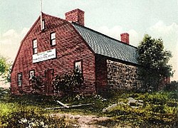
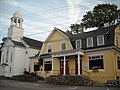
Like Bar Harbor and Newport, Rhode Island, York became a fashionable summer resort, and retains many distinctive examples of Gilded Age architecture, particularly in the Shingle style. A cluster of historic buildings in the center of York Village are maintained as museums by the Old York Historical Society.

The Yorks

Cape Neddick Light Cape Neddick Light US-ME.jpg
Cape Neddick Light

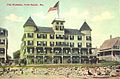
During summer months, summer residents and tourists visit Short Sands Beach, which is in the district of York Beach itself, as well as Long Sands Beach, the town's longest with more than a mile of sand stretching between York Beach and York Harbor. A number of five-star hotels and other accommodations operate in the York Beach area, although most close after summer.[ citation needed ]

A number of spots throughout The Yorks have views of the Cape Neddick Light at Nubble Rock, which has figured in both artists' work and souvenirs of the Maine coast. A photo of the Cape Neddick Light is on the Voyager 1 spacecraft labeled as Seashore, Maine. [9] Visible in clear weather is the 133-foot (41-meter) tall Boon Island Light on Boon Island, located 6.2 miles (10.0 km) off York.

Geography

According to the United States Census Bureau, the town has a total area of 131.78 square miles (341.31 km2), of which 54.67 square miles (141.59 km2) is land and 77.11 square miles (199.71 km2) is water. [1] The York watershed drains into the York River. The highest point in town is Mount Agamenticus, with an elevation of 692 feet (211 meters) above sea level. A road travels to the summit, where miles of hiking, biking and horse-riding trails are available. The lowest point in town is sea level, along the coastline with the Atlantic Ocean. York lies about 44 miles (71 km) south of Portland, 98 miles (158 km) south of Augusta, and 65 miles (105 km) north of Boston.

Government

York Town Hall York, Maine Town Hall.jpg
York Town Hall

York has a council-manager form of government.

Voter registration

32.61% Republican, 23.44% Democrat, 0.9% Green, 43.05% Unenrolled. [10] [11]

Voter Registration and Party Enrollment as of October 25, 2005 [12]
PartyPercentage
Republican 32.61%
Democratic 23.44%
Unaffiliated43.05%
Green Independent 0.90%
Total13,12916313,292100%

Education

Passaconaway Inn in York Cliffs c. 1910 Passaconaway Inn, York Cliffs, ME.jpg
Passaconaway Inn in York Cliffs c.1910

York School Department receives the largest portion (69%) of the town's budget. The town of York supports 2,000 students in four schools. Village Elementary School serves grades K–1. Coastal Ridge Elementary School provides education for grades 2–4. York Middle School serves students in grades 5–8, and York High School serves students in grades 9–12. Adult education is also available to York residents.

Demographics

Historical population
CensusPop.Note
1790 2,900
1800 2,776−4.3%
1810 3,0469.7%
1820 3,2245.8%
1830 3,4858.1%
1840 3,111−10.7%
1850 2,980−4.2%
1860 2,825−5.2%
1870 2,654−6.1%
1880 2,463−7.2%
1890 2,444−0.8%
1900 2,6689.2%
1910 2,8025.0%
1920 2,727−2.7%
1930 2,532−7.2%
1940 3,28329.7%
1950 3,256−0.8%
1960 4,66343.2%
1970 5,69022.0%
1980 8,46548.8%
1990 9,81816.0%
2000 12,85430.9%
2010 12,529−2.5%
2020 13,7239.5%
sources: [13]
The Square, Short Sands Beach at York Beach, c. 1915 The Square, York Beach, ME.jpg
The Square, Short Sands Beach at York Beach, c.1915
See Cape Neddick, Maine and York Harbor, Maine for demographic information compiled for the respective villages.

2010 census

As of the census [2] of 2010, there were 12,529 people, 5,440 households, and 3,601 families living in the town. The population density was 229.2 inhabitants per square mile (88.5/km2). There were 8,649 housing units at an average density of 158.2 per square mile (61.1/km2). The racial makeup of the town was 98.6% White, 0.4% African American, 0.1% Native American, 0.8% Asian, 0.3% from other races, and 0.8% from two or more races. Hispanic or Latino of any race were 1.0% of the population.

There were 5,440 households, of which 26.0% had children under the age of 18 living with them, 56.1% were married couples living together, 7.1% had a female householder with no husband present, 3.0% had a male householder with no wife present, and 33.8% were non-families. 28.5% of all households were made up of individuals, and 15.1% had someone living alone who was 65 years of age or older. The average household size was 2.30 and the average family size was 2.82.

The median age in the town was 49.3 years. 20.2% of residents were under the age of 18; 4.9% were between the ages of 18 and 24; 17.1% were from 25 to 44; 36.3% were from 45 to 64; and 21.5% were 65 years of age or older. The gender makeup of the town was 47.9% male and 52.1% female.

2000 census

As of the census [14] of 2000, there were 12,854 people, 5,235 households, and 3,690 families living in the town. The population density was 234.1 inhabitants per square mile (90.4/km2). There were 8,053 housing units at an average density of 146.7 per square mile (56.6/km2). The racial makeup of the town was 98.36% White, 0.25% African American, 0.11% Native American, 0.49% Asian, 0.02% Pacific Islander, 0.19% from other races, and 0.58% from two or more races. Hispanic or Latino of any race were 0.72% of the population.

There were 5,235 households, out of which 29.5% had children under the age of 18 living with them, 61.1% were married couples living together, 7.0% had a female householder with no husband present, and 29.5% were non-families. 24.0% of all households were made up of individuals, and 9.9% had someone living alone who was 65 years of age or older. The average household size was 2.42 and the average family size was 2.88.

In the town, the population was spread out, with 22.8% under the age of 18, 4.3% from 18 to 24, 25.7% from 25 to 44, 30.1% from 45 to 64, and 17.0% who were 65 years of age or older. The median age was 43 years. For every 100 females, there were 91.8 males. For every 100 females age 18 and over, there were 88.7 males.

The median income for a household in the town was $64,000, and the median income for a family was $73,400. Males had a median income of $49,415 versus $31,743 for females. The per capita income for the town was $30,895. About 1.3% of families and 3.8% of the population were below the poverty line, including 1.8% of those under the age of 18 and 6.7% of those 65 and older.

Sites of interest

York's Civil War monument Civil War Monument in York, Maine.jpg
York's Civil War monument

Civil War monument

A granite monument depicting a Civil War soldier was erected in 1906 at a traffic triangle in York Village. [15] It has been suggested by some that his uniform appears to be incorrect for a Union soldier, as he wears a brimmed fedora and goatee; some local tour guides claim that the uniform is actually Confederate. [15] Another explanation is that either the sculptor, Englishman Frederick Barnicoat, or designer John Staples, mistakenly depicted a uniform from the time of the Spanish–American War. [15] It is also possible that the 20th Maine Volunteer Infantry Regiment did wear a similar uniform. [15]

Notable people

Related Research Articles

<span class="mw-page-title-main">Baldwin, Maine</span> Town in the state of Maine, United States

Baldwin is a town in Cumberland County, Maine, United States. The population was 1,520 at the 2020 census. It is part of the Portland–South Portland–Biddeford, Maine, metropolitan statistical area.

<span class="mw-page-title-main">Cape Elizabeth, Maine</span> Town in the state of Maine, United States

Cape Elizabeth is a town in Cumberland County, Maine, United States. The town is part of the Portland–South Portland–Biddeford, Maine, metropolitan statistical area. As of the 2020 census, Cape Elizabeth had a population of 9,535.

<span class="mw-page-title-main">Raymond, Maine</span> Town in the state of Maine, United States

Raymond is a town in Cumberland County, Maine, United States. Raymond is included in the Lewiston-Auburn, Maine metropolitan New England city and town area. The population was 4,536 at the 2020 census. It is a summer recreation area and is part of the Portland–South Portland–Biddeford, Maine metropolitan statistical area. Raymond Neck is the landing for the ferry to the town of Frye Island in Sebago Lake. The Raymond school system is currently affiliated with the Windham school system in a district known as RSU 14.

<span class="mw-page-title-main">Brooklin, Maine</span> Town in the state of Maine, United States

Brooklin is a town in Hancock County, Maine, United States. The population was 827 at the 2020 census.

<span class="mw-page-title-main">Gouldsboro, Maine</span> Town in the state of Maine, United States

Gouldsboro is a town and municipality in Hancock County, Maine, United States on the Schoodic Peninsula. The town was named for Robert Gould, a landholder in the town. The town has many historically separate fishing villages, summer colonies and communities, including Birch Harbor, Prospect Harbor, South Gouldsboro, West Gouldsboro, Summer Harbor, Wonsqueak Harbor, Bunker's Harbor, Chicken Mill, Jones' Pond, Westbay, and Corea. The population was 1,703 at the 2020 census.

<span class="mw-page-title-main">Trenton, Maine</span> Town in the state of Maine, United States

Trenton is a town in Hancock County, Maine, United States, near Acadia National Park. The population was 1,584 at the 2020 census. Hancock County-Bar Harbor Airport is located in Trenton.

<span class="mw-page-title-main">Boothbay, Maine</span> Town in Maine, United States

Boothbay is a town in Lincoln County, Maine, United States. The population was 3,003 at the 2020 census. It includes the neighborhoods of Back Narrows, Dover, Linekin, Oak Hill, Ocean Point, Spruce Shores, and the villages of East Boothbay and Trevett. The surrounding Boothbay Region is a center of summer tourist activity, and a significant part of its population does not live there year-round. Five shipyards are located in the town, the largest of which is Washburn & Doughty.

<span class="mw-page-title-main">Southport, Maine</span> Town in the state of Maine, United States

Southport is a town and archipelago in Lincoln County, Maine, United States. The population was 622 at the 2020 census. It includes the neighborhoods of Capitol Island, Cozy Harbor, East Side, Newagen, Pine Cliff, and West Southport, and the village of Squirrel Island. The majority of the town's residents live on its main island, Southport Island.

Sweden is a town in Oxford County, Maine, United States. The population was 406 at the 2020 census. Set among hills, forests and ponds, Sweden includes the village of East Sweden.

<span class="mw-page-title-main">Phippsburg, Maine</span> Town in the state of Maine, United States

Phippsburg is a town in Sagadahoc County, Maine, United States, on the west side of the mouth of the Kennebec River. The population was 2,155 at the 2020 census. It is within the Portland–South Portland–Biddeford, Maine, metropolitan statistical area. A tourist destination, Phippsburg is home to Bates-Morse Mountain Conservation Area, Fort Popham State Historic Site; it is also home to Fort Baldwin which overlooks Fort Popham, and Popham Beach State Park, as well as Pond Island National Wildlife Refuge. The town includes part of Winnegance.

<span class="mw-page-title-main">Woolwich, Maine</span> Town in Maine, United States

Woolwich is a town in Sagadahoc County, Maine, United States. The population was 3,068 at the 2020 census. It is part of the Portland–South Portland–Biddeford, Maine metropolitan statistical area. Woolwich is a suburb of the city of Bath located on the opposite shore of Merrymeeting Bay.

<span class="mw-page-title-main">Solon, Maine</span> Town in the state of Maine, United States

Solon is a town in Somerset County, Maine, United States. The population was 978 at the 2020 census.

<span class="mw-page-title-main">Cutler, Maine</span> Town in the state of Maine, United States

Cutler is a town in Washington County, Maine, United States. The town was named after Joseph Cutler, an early settler, who hailed from Newburyport, Massachusetts. The population was 524 at the 2020 census.

<span class="mw-page-title-main">Cape Neddick, Maine</span> Census-designated place in Maine, United States

Cape Neddick is a census-designated place (CDP) in the town of York in York County, Maine, United States. The population was 2,568 at the 2010 census. It is part of the Portland–South Portland–Biddeford, Maine Metropolitan Statistical Area.

<span class="mw-page-title-main">York Harbor, Maine</span> Census-designated place in Maine, United States

York Harbor is a census-designated place (CDP) in the town of York in York County, Maine, United States. The population was 3,033 at the 2010 census. York Harbor is a distinguished former Gilded Age summer colony noted for its resort architecture. It is part of the Portland–South Portland–Biddeford, Maine Metropolitan Statistical Area.

<span class="mw-page-title-main">Pocasset, Massachusetts</span> Census-designated place in Massachusetts, United States

The village of Pocasset is a census-designated place (CDP) in the town of Bourne in Barnstable County, Massachusetts, United States, located on Buzzards Bay. The population was 2,851 at the 2010 census.

<span class="mw-page-title-main">Errol, New Hampshire</span> Town in New Hampshire, United States

Errol is a town in Coös County, New Hampshire, United States. The population was 298 at the 2020 census. It is located north of the White Mountains along Route 16 at its intersection of Route 26. It has a municipal airport with a single, unpaved runway.

<span class="mw-page-title-main">Baileys Harbor, Wisconsin</span> Town in Wisconsin, United States

Baileys Harbor is a town in Door County, Wisconsin, United States. The population was 1,003 at the 2000 census. The unincorporated community of Peninsula Center is located in the town. The census-designated place of Baileys Harbor is also located with the town.

<span class="mw-page-title-main">Cape Neddick Light</span> Lighthouse in Maine, US

The Cape Neddick Light is a lighthouse in Cape Neddick, York, Maine. In 1874 Congress appropriated $15,000 to build a light station at the "Nubble" and in 1879 construction began. Cape Neddick Light Station was dedicated by the U.S. Lighthouse Service and put into use in 1879. It is still in use today.

York Beach is a village within the town of York, Maine, United States. The York Beach area consists of Long Sands and Short Sands beaches on the Atlantic Ocean in the Gulf of Maine. The two beaches are separated by Cape Neddick. Cape Neddick and York Beach together comprise the Cape Neddick census-designated place, with a year-round population of 2,568. The town of York consists of the communities of York Beach, Cape Neddick, York Harbour, and the village of York. The town is home to 12,529 residents, though rising to an estimated 52,000 during the summer months.

References

  1. 1 2 "US Gazetteer files 2010". United States Census Bureau . Retrieved December 16, 2012.
  2. 1 2 "U.S. Census website". United States Census Bureau . Retrieved December 16, 2012.
  3. "Census - Geography Profile: York town, York County, Maine" . Retrieved January 11, 2022.
  4. 1 2 Coolidge, Austin J.; John B. Mansfield (1859). A History and Description of New England. Boston, Massachusetts: A.J. Coolidge. pp.  369–372. coolidge mansfield history description new england 1859.
  5. Geo. J. Varney (1886). "History of York, Maine" . Retrieved December 4, 2009.
  6. Dummer, Michael (June 2005). "5: Richard and Early Days in New England". The Family of Dummer (7th ed.). p. 26.
  7. "Museums of Old York".
  8. Varney, George J. (1886), Gazetteer of the state of Maine. York, Boston: Russell
  9. "Voyager - Images on the Golden Record".
  10. reported in June 2002 by the State of Maine
  11. "YORK, MAINE, York County, 03909: Our Maine Towns & Cities: Schools, Homes, government, Census Demographics, and more..." www.bangornews.com. Archived from the original on September 27, 2007.
  12. "Registration and Party Enrollment Statistics as of October 25, 2005". Connecticut Secretary of State. Archived from the original (PDF) on September 27, 2007. Retrieved October 2, 2006.
  13. accessed March, 2010.
  14. "U.S. Census website". United States Census Bureau . Retrieved January 31, 2008.
  15. 1 2 3 4 Dandurant, Karen (September 26, 2004). "Soldier's garb generates doubts about monument". Seacoast Online. Retrieved May 31, 2017.
  16. "Representative Walter Gerard Runte, Jr". www.maine.gov. Retrieved December 14, 2023.
  17. Albert Bigelow Paine, Mark Twain, A Biography; The Personal and Literary Life of Samuel Langhorne Clemens