
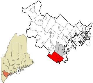
York County is the southwesternmost county in the U.S. state of Maine, along the state of New Hampshire's eastern border. It is divided from Strafford County, New Hampshire, by the Salmon Falls River, and the connected tidal estuary—the Piscataqua River. York County was permanently established in 1639. It is the state's oldest county and one of the oldest in the United States. Several of Maine's earliest colonial settlements are found in the county. As of the 2020 census, its population was 211,972, making it Maine's second-most populous county. Its county seat is Alfred. York County is part of the Portland–South Portland, Maine Metropolitan Statistical Area.

Baldwin is a town in Cumberland County, Maine, United States. The population was 1,520 at the 2020 census. It is part of the Portland–South Portland–Biddeford, Maine, metropolitan statistical area.

South Bristol is a town in Lincoln County, Maine, United States. The population was 1,127 at the 2020 census. A fishing and resort area, South Bristol includes the villages of Walpole and Christmas Cove, the latter on Rutherford Island. The town has six nature preserves.

Biddeford is a city in York County, Maine, United States. It is the principal commercial center of York County. Its population was 22,552 at the 2020 census. The twin cities of Saco and Biddeford include the resort communities of Biddeford Pool and Fortunes Rocks. The town is the site of the University of New England and the annual La Kermesse Franco-Americaine Festival. First visited by Europeans in 1616, it is the site of one of the earliest European settlements in the United States. It is home to Saint Joseph's Church, the tallest building in Maine.

Dayton is a town in York County, Maine, United States; the town is located near the Saco-Biddeford city area. Dayton borders Biddeford by land, and borders Saco on the Saco River. It is also part of the Portland–South Portland–Biddeford, Maine metropolitan statistical area. The population was 2,129 at the 2020 census. Dayton is one of the smallest towns in York County.

Saco is a city in York County, Maine, United States. The population was 20,381 at the 2020 census. It is home to Ferry Beach State Park, Funtown Splashtown USA, Thornton Academy, as well as General Dynamics Armament Systems, a subsidiary of the defense contractor General Dynamics. Saco sees much tourism during summer months due to its amusement parks, Camp Ellis Beach and Pier, Ferry Beach State Park, and proximity to Old Orchard Beach.

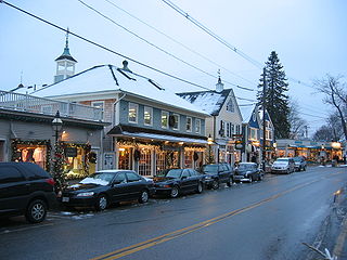
Kennebunk is a town in York County, Maine, United States. The population was 11,536 at the 2020 census. Kennebunk is home to several beaches, the Rachel Carson National Wildlife Refuge, the 1799 Kennebunk Inn, many historic shipbuilders' homes, the Brick Store Museum and the Nature Conservancy Kennebunk Plains, with 1,500 acres (6 km2) of nature trails and blueberry fields.
Kennebunkport is a resort town in York County, Maine, United States. The population was 3,629 people at the 2020 census. It is part of the Portland–South Portland–Biddeford metropolitan statistical area.
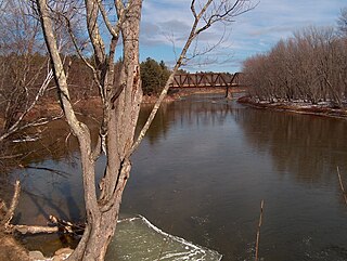
The Saco River is a river in northeastern New Hampshire and southwestern Maine in the United States. It drains a rural area of 1,703 square miles (4,410 km2) of forests and farmlands west and southwest of Portland, emptying into the Atlantic Ocean at Saco Bay, 136 miles (219 km) from its source. It supplies drinking water to roughly 250,000 people in thirty-five towns; and historically provided transportation and water power encouraging development of the cities of Biddeford and Saco and the towns of Fryeburg and Hiram.

Saco Bay is a small curved embayment of the Gulf of Maine on the Atlantic coast of Maine in the United States.

Wood Island Light is an active lighthouse on the eastern edge of Wood Island in Saco Bay, on the southern coast of Maine. The light is just outside the entrance to Biddeford Pool and the end of the Saco River. The lighthouse is a 47-foot (14 m) conical white tower of granite rubble. The light itself sits 71 feet (22 m) above mean high water. Its automated beacon alternates between green and white every 10 seconds.

Cape Porpoise is a small coastal village in the town of Kennebunkport, Maine, United States, and was the original English settlement of the town. It is located northeast of Dock Square and southwest of Goose Rocks Beach. The village occupies the mainland adjacent to Cape Porpoise Harbor. More than a dozen islands protect the deep natural harbor. The ZIP Code for Cape Porpoise is 04014.

The Rachel Carson National Wildlife Refuge is a 9,125-acre (37 km2) National Wildlife Refuge made up of several parcels of land along 50 miles (80 km) of Maine's southern coast. Created in 1966, it is named for environmentalist and author Rachel Carson, whose book Silent Spring raised public awareness of the effects of DDT on migratory songbirds, and of other environmental issues.
Scarborough is a town in Cumberland County on the southern coast of the U.S. state of Maine. Located about 7 miles (11 km) south of Portland, Scarborough is part of the Portland–South Portland–Biddeford, Maine metropolitan statistical area. The population was 22,135 at the 2020 census, making it the most populous town in Maine.
The Little River is a 7.6-mile-long (12.2 km) tributary of Goosefare Bay in the U.S. state of Maine. It rises in Biddeford and flows southeast, becoming the boundary between Biddeford and Kennebunkport for the final 2.8 miles (4.5 km) of its course. It empties into Goosefare Bay on the Atlantic Ocean at the east end of Kennebunkport's Goose Rocks Beach.

Fort Williams is a former United States Army fort in Cape Elizabeth, Maine which operated from 1872 to 1964. It was part of the Coast Defenses of Portland, later renamed the Harbor Defenses of Portland, a command which protected Portland's port and naval anchorage 1904–1950. After its closure, it was redeveloped into Fort Williams Park.
Fort Mary was a British fort built in 1688 that saw action during Queen Anne's War and was located in Saco, Maine overlooking Winter Harbor / Biddeford Pool. The fort replaced Fort Saco (1708), which was built at Saco Falls during King William's War. The commander of the fort during King William's War was Captain John Hill. The fort was attacked in the Northeast Coast Campaign (1703) and natives killed 11 English and took 24 prisoner. Saco was raided again in 1704 and 1705. They overwhelmed the garrison in the fort at Winter Harbor, forcing them to submit to terms of capitulation. Winter Harbor was raided two more times, in 1707 and 1710.

Hills Beach is a seaside community in Biddeford, York County, Maine, United States, approximately 85 miles (140 km) north of Boston, Massachusetts.
The 240th Coast Artillery Regiment was a Coast Artillery Corps regiment in the Maine National Guard. It garrisoned the Harbor Defenses of Portland, Maine 1924–1944.


