Fort Popham

Last updated
Fort Popham Memorial
Fort Popham and the Atkins Bay arm of the Kennebec River.jpg
Fort Popham and the Kennebec River
USA Maine relief location map.svg
Red pog.svg
Fort Popham
Location in Maine
Location Phippsburg, Maine
Coordinates 43°45′17″N69°47′02″W / 43.75472°N 69.78389°W / 43.75472; -69.78389 [1]
Built1861 (1861)
ArchitectUS Army Corps of Engineers
NRHP reference No. 69000012
Fort Popham
Part of Coast Defenses of the Kennebec
Phippsburg, Maine
TypeFortification
Site information
OwnerPublic - State of Maine
Controlled byState of Maine
Open to
the public
partly
Site history
Built1857–1869
Built by U.S. Army Corps of Engineers
In use1864–1865, 1898–1899, 1917–1918, 1941–1945
MaterialsGranite
Garrison information
Garrison
Added to NRHP1 October 1969

Fort Popham is a Civil War-era coastal defense fortification at the mouth of the Kennebec River in Phippsburg, Maine. It is located in sight of the short-lived Popham Colony and, like the colony, named for George Popham, the colony's leader. The site is preserved as Fort Popham State Historic Site. [2]

Contents

Predecessors

During the American Revolution a minor fortification stood on this site; in 1808 the federal government built a small battery to accommodate guns on field carriages on this location as part of the Second System of fortifications that guarded the coast. [3] These forts and batteries were built shortly after the passage of Thomas Jefferson's Embargo Act of 1807, which prohibited all exports from the US as an attempt to exert pressure on Britain and France, which had been taking actions against US shipping. The first use of some of these forts was to enforce the embargo. [4] The embargo was deeply unpopular in New England and had severe economic effects there; the embargo was repealed in March 1809, but the situation with Britain ultimately led to the War of 1812. It was felt that these forts were built as much to enforce the embargo as to defend the country, and they were derisively known as "embargo forts". The battery is mentioned in the Secretary of War's reports on fortifications for December 1808 and December 1811. [5] It was called the "Battery on Hunnewell's Point" or the "Georgetown Battery" (at the time Georgetown included Phippsburg). [6] [7] In 1811 it was described as "An enclosed work, with a battery of six heavy guns mounted, a small magazine, and wooden barracks for 40". [8] The battery remained manned until 1815 and saw minor action during the War of 1812. After the war four of the guns were relocated to a new battery at Cox's Head, north of Fort Popham on the west bank of the Kennebec. This was a brick fort with barracks for 105 men. [6]

History

Construction of Fort Popham was authorized in 1857 as part of the Third System of fortifications but did not begin until 1861. The fort was built from granite blocks quarried on nearby Fox and Dix Islands. It had a 30-foot (9 m)-high wall facing the mouth of the Kennebec River and was built in a crescent shape, measuring approximately 500 feet (150 m) in circumference.

During the closing months of the American Civil War, from October 1864 to July 1865, the fort was garrisoned by the 7th Unassigned Company of Maine Infantry. The 7th Company was commanded by Captain Augustin Thompson, who is best known as the inventor of Moxie soda. [9]

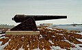
Fort Popham was originally designed to mount 42 heavy guns, a mix of 10-inch and 15-inch Rodman guns, but construction was halted in 1869 with only two of the planned three tiers completed. [10] In the late 19th century, Fort Popham's armament consisted of 36 Rodman guns and some 300-pounder (10-inch) and smaller Parrott rifles. One of the Rodman guns was donated to the town of Bowdoinham to remember its soldiers who died in the Civil War. The cannon is still there. A 100-pounder (6.4-inch) Parrott rifle sits near the fort grounds; it was listed as being at the fort in 1903. [11] The back side of Fort Popham was built with a low moated curtain containing a central gate and 20  musket ports.

War experience showed that masonry forts were vulnerable to modern rifled guns. As a result, in 1869 construction at Fort Popham stopped before the fortification was completed. The fort was garrisoned again after additional work was performed during the Spanish–American War and World War I. In the 1890s Fort Popham received new facilities for a controlled minefield in the river at the fort as part of the Endicott program of improved fortifications. [12] In 1898, shortly after the Spanish–American War broke out, Congress made numerous emergency appropriations, including $3,200 to deploy the mines in the Kennebec. [13] In 1899, following the war, a single 8-inch M1888 gun was mounted near the fort on a converted Rodman carriage, joining four 15-inch Rodman guns and the 100-pounder Parrott rifle that remains near the fort; the 8-inch gun was removed in 1910. [11] [13] [14] This was an emergency measure to provide modern guns at threatened locations until the Endicott program forts could be completed. Under this program, construction of Fort Baldwin on the headland above Fort Popham began in 1905 with longer-range guns, which eventually rendered Fort Popham obsolete. [15] However, at the time Fort Baldwin was built, Fort Popham remained important due to the minefield facilities.

Fort Popham was probably part of the Coast Defenses of the Kennebec command at some point. However, references indicate this command was combined with the Coast Defenses of Portland at some time prior to 1917. [16] During World War I, Forts Popham and Baldwin were garrisoned by about 200 men of the 13th and 29th Coast Artillery companies of the Coast Defenses of Portland. [17] Although Fort Baldwin was disarmed in 1924, the mine facilities at Fort Popham may have remained operational through World War II, during which Fort Baldwin was rearmed with towed artillery. [15]

Present

The fort, located two miles (3 km) from popular Popham Beach State Park, is open to the public as Fort Popham State Historic Site. It was added to the National Register of Historic Places as Fort Popham Memorial on October 1, 1969, reference number 69000012.

See also

Related Research Articles

<span class="mw-page-title-main">Fort William and Mary</span> United States historic place

Fort William and Mary was a colonial fortification in Britain's worldwide system of defenses, defended by soldiers of the Province of New Hampshire who reported directly to the royal governor. The fort, originally known as "The Castle," was situated on the island of New Castle, New Hampshire, at the mouth of the Piscataqua River estuary. It was renamed Fort William and Mary circa 1692, after the accession of the monarchs William III and Mary II to the British throne. It was captured by Patriot forces, recaptured, and later abandoned by the British in the Revolutionary War. The fort was renamed Fort Constitution in 1808 following rebuilding. The fort was further rebuilt and expanded through 1899 and served actively through World War II.

<span class="mw-page-title-main">Fort Knox (Maine)</span> Fort in Maine, United States

Fort Knox, now Fort Knox State Park or Fort Knox State Historic Site, is located on the western bank of the Penobscot River in the town of Prospect, Maine, about 5 miles (8.0 km) from the mouth of the river. Built between 1844 and 1869, it was the first fort in Maine built entirely of granite; most previous forts used wood, earth, and stone. It is named after Major General Henry Knox, the first U.S. Secretary of War and Commander of Artillery during the American Revolutionary War, who at the end of his life lived not far away in Thomaston. As a virtually intact example of a mid-19th century granite coastal fortification, it was added to the National Register of Historic Places in 1969 and declared a National Historic Landmark on December 30, 1970. Fort Knox also serves as the entry site for the observation tower of the Penobscot Narrows Bridge that opened to the public in 2007.

<span class="mw-page-title-main">Fort McClary</span> United States historic place

Fort McClary is a former defensive fortification of the United States military located along the southern coast at Kittery Point, Maine at the mouth of the Piscataqua River. It was used throughout the 19th century to protect approaches to the harbor of Portsmouth, New Hampshire and the Portsmouth Naval Shipyard in Kittery. The property and its surviving structures are now owned and operated by the State of Maine as Fort McClary State Historic Site, including a blockhouse dating from 1844.

<span class="mw-page-title-main">House Island (Maine)</span> Private island in Maine, United States

House Island is a private island in Portland Harbor in Casco Bay, Maine, United States. It is part of the City of Portland. The island is accessible only by boat. Public access is prohibited, except for an on-request tour sanctioned by the island's owners. House Island includes three buildings on the east side and Fort Scammell on the west side. The buildings are used as vacation rentals and other summer residences. The island's name derives from the site of an early European house, believed that built by Capt. Christopher Levett, an English explorer of the region.

<span class="mw-page-title-main">Fort Edgecomb</span> Historic site in Maine, United States

Fort Edgecomb, built in 1808–1809, is a two-story octagonal wooden blockhouse with restored fortifications located on Davis Island in the town of Edgecomb, Lincoln County, Maine, United States. It is the centerpiece of the Fort Edgecomb State Historic Site. It was added to the National Register of Historic Places in 1969, with its boundaries increased to create a historic district in 1991.

<span class="mw-page-title-main">Fort Adams</span>

Fort Adams is a former United States Army post in Newport, Rhode Island that was established on July 4, 1799 as a First System coastal fortification, named for President John Adams who was in office at the time. Its first commander was Captain John Henry who was later instrumental in starting the War of 1812. The current Fort Adams was built 1824–57 under the Third System of coastal forts; it is part of Fort Adams State Park today.

<span class="mw-page-title-main">Fort Preble</span>

Fort Preble was a military fort in South Portland, Maine, United States, built in 1808 and progressively added to through 1906. The fort was active during all major wars from the War of 1812 through World War II. The fort was deactivated in 1950. It is now on the campus of Southern Maine Community College.

<span class="mw-page-title-main">Fort Baldwin</span> Historic site in Maine, United States

Fort Baldwin is a former coastal defense fortification near the mouth of the Kennebec River in Phippsburg, Maine, United States, preserved as the Fort Baldwin State Historic Site. It was named after Jeduthan Baldwin, an engineer for the Continental Army during the American Revolution. The site was listed on the National Register of Historic Places in 1979.

<span class="mw-page-title-main">Fort Winthrop</span>

Fort Winthrop, built in 1808 and named Fort Warren until 1834, was a defensive fortification in Boston Harbor named after John Winthrop, an early governor of the Massachusetts Bay Colony.

<span class="mw-page-title-main">Seacoast defense in the United States</span> Coastal forts construction and maintenance in the U.S.

Seacoast defense was a major concern for the United States from its independence until World War II. Before airplanes, many of America's enemies could only reach it from the sea, making coastal forts an economical alternative to standing armies or a large navy. After the 1940s, it was recognized that fixed fortifications were obsolete and ineffective against aircraft and missiles. However, in prior eras foreign fleets were a realistic threat, and substantial fortifications were built at key locations, especially protecting major harbors.

<span class="mw-page-title-main">Fort Rodman</span> United States historic place

Fort Taber District or the Fort at Clark's Point is a historic American Civil War-era military fort on Wharf Road within the former Fort Rodman Military Reservation in New Bedford, Massachusetts. The fort is now part of Fort Taber Park, a 47-acre town park located at Clark's Point. Fort Taber was an earthwork built nearby with city resources and garrisoned 1861-1863 until Fort Rodman was ready for service.

<span class="mw-page-title-main">Fort Williams (Maine)</span>

Fort Williams is a former United States Army fort in Cape Elizabeth, Maine which operated from 1872 to 1964. It was part of the Coast Defenses of Portland, later renamed the Harbor Defenses of Portland, a command which protected Portland's port and naval anchorage 1904–1950. After its closure, it was redeveloped into Fort Williams Park.

<span class="mw-page-title-main">Battery Steele</span>

Battery Steele is a United States military fortification on Peaks Island, Portland, Maine in Casco Bay. Completed in 1942 as part of World War II, it is located on 14 acres (5.7 ha) on the oceanside area of the island, formerly part of the Peaks Island Military Reservation. It is named for Harry L. Steele, who was a Coast Artillery officer during World War I. It was armed with two 16-inch MkIIMI guns and, with a 12-inch gun battery at Fort Levett on Cushing Island, replaced all previous heavy guns in the Harbor Defenses of Portland. It was built to protect Casco Bay, particularly Portland harbor, from Kennebunk to Popham Beach in Phippsburg. According to Kim MacIsaac and historian Joel Eastman in An Island at War, “Battery Steele is not only the largest gun battery built on Peaks Island, but also an example of the largest battery ever built anywhere in the United States.” In 1995, after decades of non-use, the Peaks Island Land Preserve, a community land preservation group, formed to purchase the area and forever preserve it as a public space. On October 20, 2005, the property was listed on the National Register of Historic Places. Other coast defense structures on the island include fire control towers and the counterweight for a disappearing searchlight tower.

<span class="mw-page-title-main">Fort Stark</span>

Fort Stark is a former military fortification in New Castle, New Hampshire, United States. Located at Jerry's Point on the southeastern tip of New Castle Island, most of the surviving fort was developed in the early 20th century, following the Spanish–American War, although there were several earlier fortifications on the site, portions of which survive. The fort was named for John Stark, a New Hampshire officer who distinguished himself at the Battle of Bennington in the American Revolution. The purpose of Fort Stark was to defend the harbor of nearby Portsmouth and the Portsmouth Naval Shipyard. The fort remained in active use through the Second World War, after which it was used for reserve training by the US Navy. The property was partially turned over to the state of New Hampshire in 1979, which established Fort Stark Historic Site, and the remainder of the property was turned over in 1983. The grounds are open to the public during daylight hours.

<span class="mw-page-title-main">Fort Sumner (Maine)</span>

Fort Sumner was a coastal defense fortification on Munjoy Hill in Portland, Maine, United States. It was built in 1794 as part of the first system of coastal fortifications built by the United States. It was reportedly originally named Fort Allen after the nearby Revolutionary War battery that probably became part of Fort Sumner, but was renamed in 1797 after Increase Sumner, the incumbent Governor of Massachusetts, of which Maine was then a part. The location is now Fort Sumner Park.

<span class="mw-page-title-main">Harbor Defenses of Portland</span> Military unit

The Harbor Defenses of Portland was a United States Army Coast Artillery Corps harbor defense command. It coordinated the coast defenses of Portland, Maine, the mouth of the Kennebec River, and surrounding areas from 1895 to 1950, beginning with the Endicott program. These included both coast artillery forts and underwater minefields. The command originated circa 1895 as the Portland Artillery District, was renamed Coast Defenses of Portland in 1913, and again renamed Harbor Defenses of Portland in 1925.

The Harbor Defenses of Portsmouth was a United States Army Coast Artillery Corps harbor defense command. It coordinated the coast defenses of Portsmouth, New Hampshire and the nearby Portsmouth Naval Shipyard in Kittery, Maine from 1900 to 1950, both on the Piscataqua River, beginning with the Endicott program. These included both coast artillery forts and underwater minefields. The command originated circa 1900 as the Portsmouth Artillery District, was renamed Coast Defenses of Portsmouth in 1913, and again renamed Harbor Defenses of Portsmouth in 1925.

<span class="mw-page-title-main">Harbor Defenses of Boston</span> Military unit

The Harbor Defenses of Boston was a United States Army Coast Artillery Corps harbor defense command. It coordinated the coast defenses of Boston, Massachusetts from 1895 to 1950, beginning with the Endicott program. These included both coast artillery forts and underwater minefields. The command originated circa 1895 as the Boston Artillery District, was renamed Coast Defenses of Boston in 1913, and again renamed Harbor Defenses of Boston in 1925.

<span class="mw-page-title-main">Harbor Defenses of New Bedford</span> Military unit

The Harbor Defenses of New Bedford was a United States Army Coast Artillery Corps harbor defense command. It coordinated the coast defenses of New Bedford, Massachusetts and the nearby Cape Cod Canal from 1900 to 1950, beginning with the Endicott program. These included a coast artillery fort and an underwater minefield. The command originated circa 1900 as the New Bedford Artillery District, was renamed Coast Defenses of New Bedford in 1913, and again renamed Harbor Defenses of New Bedford in 1925.

References

  1. "Fort Popham (historical)". Geographic Names Information System . United States Geological Survey, United States Department of the Interior.
  2. "Fort Popham State Historic Site". Department of Agriculture, Conservation and Forestry. Retrieved January 22, 2023.
  3. Wade, Arthur P. (2011). Artillerists and Engineers: The Beginnings of American Seacoast Fortifications, 1794-1815. CDSG Press. p. 235. ISBN   978-0-9748167-2-2.
  4. Wade, p. 131
  5. Wade, pp. 235, 241
  6. 1 2 Coast Defenses of the Kennebec River at NorthAmericanForts.com
  7. Town of Georgetown, Maine website
  8. Wade, p. 241
  9. National Archives digitized microfilm record, Microcopy 594, Roll 71, Volunteer Maine Militia, Nineteenth Infantry through 30th Unassigned Infantry
  10. Weaver II, John R. (2018). A Legacy in Brick and Stone: American Coastal Defense Forts of the Third System, 1816-1867, 2nd Ed. McLean, VA: Redoubt Press. pp. 88–90. ISBN   978-1-7323916-1-1.
  11. 1 2 FortWiki article on Fort Popham
  12. Fort Popham at NorthAmericanForts.com
  13. 1 2 Congressional serial set, 1900, Report of the Commission on the Conduct of the War with Spain, Vol. 7, pp. 3778–3780, Washington: Government Printing Office
  14. Berhow, Mark A., ed. (2004). American Seacoast Defenses, A Reference Guide (Second ed.). CDSG Press. pp. 182–183, 202. ISBN   0-9748167-0-1.
  15. 1 2 FortWiki article on Fort Baldwin
  16. Rinaldi, Richard A. (2004). The U. S. Army in World War I: Orders of Battle. General Data LLC. pp. 165–166. ISBN   0-9720296-4-8.
  17. NRIS entry for Fort Baldwin

Further reading

For this fort's role in Jefferson's embargo, see Smith, Joshua M. "Maine's Embargo Forts", Maine History, Vol. 44, No. 2 (April 2009), pp. 143–154.

For this fort's role in the War of 1812, see Burrage, Rev. Henry S. "Captain John Wilson and Some Military Matters in the War of 1812", Collections and Proceedings of the Maine Historical Society, second series, 10 (1899), pp. 403–429.