Mount Kineo is a prominent geological feature located on a 1,150-acre (470 ha) peninsula that extends from the easterly shore of Moosehead Lake in the northern forest of Maine. With 700-foot (210 m) cliffs rising straight up from the water, it is the central feature of Mount Kineo State Park, a protected area of 800 acres (320 ha) managed by the Maine Department of Agriculture, Conservation and Forestry.

Quoddy Head State Park is a public recreation area in Lubec, Maine, located on the easternmost point of land in the continental United States. On its 541 acres (219 ha), purchased by the state in 1962, the state park features 5 miles (8 km) of hiking trails, extensive forests, two bogs, diverse habitat for rare plants, and the striking, red-and-white striped lighthouse tower of West Quoddy Head Light.

Bradbury Mountain State Park is a public recreation area in the town of Pownal, Cumberland County, Maine, managed by the Department of Agriculture, Conservation and Forestry. The state park covers 730 acres (300 ha).
Mount Blue State Park is a public recreation area covering 7,489 acres (3,031 ha) in the town of Weld, Franklin County, Maine. The state park's bifurcated land includes acreage on the west shore of Webb Lake as well as Mount Blue and other peaks to the east of the lake. The park is connected by road with the 10,555-acre (4,271 ha) Tumbledown Public Lands, the site of Little Jackson Mountain, Tumbledown Mountain, and Tumbledown Pond, an alpine lake near the top of Tumbledown and Little Jackson mountains. The park and public lands are managed by the Maine Department of Agriculture, Conservation and Forestry.

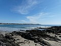
Reid State Park is a public recreation area overlooking the Atlantic Ocean on Georgetown Island in Sagadahoc County, Maine, United States. The 770-acre (310 ha) park is noted for its sandy beaches and sand dunes—both rare in the state of Maine—plus its rocky tidepools, salt marshes, and tidal lagoon. The park is managed by the Maine Department of Agriculture, Conservation and Forestry.

Sebago Lake State Park is a public recreation area encompassing 1,342 acres (543 ha) on the north shore of Sebago Lake in the towns of Naples and Casco, Cumberland County, Maine. It opened in 1938 as one of Maine's original five state parks. The mostly forested park is divided into east and west sections by the Songo River. It is managed by the Maine Department of Agriculture, Conservation and Forestry.
Two Lights State Park is a public recreation area occupying 41 acres (17 ha) of headland on Cape Elizabeth, Maine, that offers views of Casco Bay and the Atlantic Ocean. The state park, which opened in 1961, is named after the twin Cape Elizabeth Lights, although there are no lighthouses in the park itself. In addition to rocky headlands, the park includes the remains of a World War II–era seacoast battery bunker and a fire control tower. It is managed by the Maine Department of Agriculture, Conservation and Forestry.

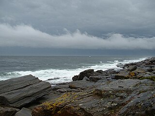
Cobscook Bay State Park is a public recreation area occupying 888 acres (359 ha) on the western shore of Cobscook Bay in Washington County, Maine. The park offers a view of dramatically changing tides that on average can rise to 24 feet (7.3 m) high with some reaching as high as 28 feet (8.5 m). The name Cobscook is a Maliseet-Passamaquoddy word for boiling tides. The state park is located on Whiting Bay approximately 6 miles (9.7 km) south of Dennysville and 6 miles (9.7 km) north of Whiting. It is managed by the Maine Department of Agriculture, Conservation and Forestry.
Warren Island State Park is state-owned island and public recreation area on Penobscot Bay in the town of Islesboro, Waldo County, Maine. The 70-acre (28 ha) state park sits about ½-mile from Islesboro Island and 3 miles (4.8 km) offshore from the mainland at Lincolnville. The island was acquired by the state of Maine for one dollar in 1959. Hiking trails, campsites, and open-faced shelters are found on the island; a pier allows access by private boat.

Swan Lake State Park is a public recreation area at the north end of 3-mile-long (4.8 km) Swan Lake in the town of Swanville, Waldo County, Maine. The state park's 67 acres (27 ha) offer opportunities for swimming, picnicking, canoeing, and fishing. The 1,370-acre (550 ha) lake supports populations of smallmouth bass, landlocked salmon, white perch, brook trout, and wild togue. The park is managed by the Maine Department of Agriculture, Conservation and Forestry.

Grafton Notch State Park is a public recreation area in Grafton Township, Oxford County, Maine. The state park occupies 3,129 acres (1,266 ha) surrounding Grafton Notch, the mountain pass between Old Speck Mountain and Baldpate Mountain, mountains in the Mahoosuc Range. The park is abutted by the eastern and western sections of the Mahoosuc Public Reserved Land, which total 31,807 acres (12,872 ha). The park is managed by the Department of Agriculture, Conservation and Forestry.
Birch Point State Park is a public recreation area occupying 62 acres (25 ha) on Penobscot Bay in the town of Owls Head, Knox County, Maine. The state park features a sandy, crescent-shaped "pocket beach" with scenic views of the Muscle Ridge Islands dotting Muscle Ridge Channel. The park is managed by the Maine Department of Agriculture, Conservation and Forestry.
Camden Hills State Park is a 5,710-acre (2,310 ha) public recreation area overlooking Penobscot Bay in the town of Camden, Knox County, Maine. The state park features multi-use trails to Mount Battie, Mount Megunticook, and other scenic locales. The park is managed by the Maine Department of Agriculture, Conservation and Forestry.

Shackford Head State Park is a public recreation area on Moose Island in the city of Eastport, Washington County, Maine. The 87-acre (35 ha) state park occupies a peninsula that separates Cobscook Bay and Broad Cove. The land is named for John Shackford, an American Revolutionary War soldier who once owned the headlands. The park is managed by the Maine Department of Agriculture, Conservation and Forestry.
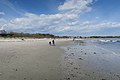
Ferry Beach State Park is a public recreation area occupying 117 acres (47 ha) on Saco Bay north of the mouth of the Saco River in Saco, Maine. The state park encompasses a sandy Atlantic Ocean beach, inland hiking trails, and nature center. The inland portion of the park is noted for its pocket swamp and tupelo trees found at the northern limit of the species's range. The park is managed by the Maine Department of Agriculture, Conservation and Forestry.

Fort Point State Park is a public recreation area that overlooks Penobscot Bay from the easternmost tip of Cape Jellison in the town of Stockton Springs, Maine. The state park's 156 acres (63 ha) feature the Fort Point Light and the site of historic Fort Pownall. The park offers hiking trails, picnicking, and fishing.

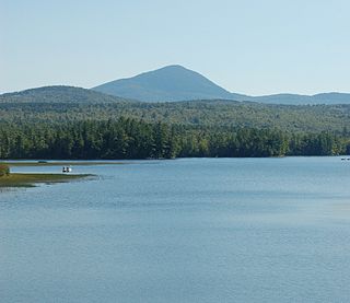
Rangeley Lake State Park is a public recreation area occupying 870 acres (350 ha) on the southern shore of Rangeley Lake in Franklin County, Maine. The state park is located partly in the town of Rangeley and partly in Rangeley Plantation. It is managed by the Maine Department of Agriculture, Conservation and Forestry.

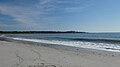
Popham Beach State Park is a public recreation area covering 605 acres (245 ha) on the Atlantic Ocean in the town of Phippsburg, Sagadahoc County, Maine. It is the state's highest volume day use State Park. The state park occupies a dynamic shoreline landscape that has created a peninsula between the mouth of the Morse River and the Atkins Bay portion of the Kennebec River. The park is managed by the Maine Department of Agriculture, Conservation and Forestry.
Range Ponds State Park is a public recreation area wrapping around the eastern end of Lower Range Pond in the town of Poland in Androscoggin County, Maine. The state park offers a sandy beach with lifeguard-supervised swimming, kayaking, limited motorized boating, hiking trails, and fishing. Mountain biking trails, built with the help of local volunteers, provide intermediate level, single-track loops off a central double-track trail that winds through mature pine and hardwood forests.
Holbrook Island Sanctuary is a publicly owned nature preserve with recreational features occupying 1,345 acres (544 ha) on Penobscot Bay in the town of Brooksville, Hancock County, Maine. The site includes upland forest and meadows, wetland marshes and ponds, and rocky mainland shores in addition to off-shore Holbrook Island. The state park is managed by the Maine Department of Agriculture, Conservation and Forestry.