
Cape May Point State Park is a 244 acres (0.99 km2) state park located in Lower Township, New Jersey, with a Cape May Point postal address. The park offers walking, hiking and nature trails as well as beaches, an exhibit gallery, a ranger office and is the site of the Cape May Light. The park is operated and maintained by the New Jersey Division of Parks and Forestry.

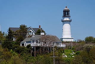
Quoddy Head State Park is a public recreation area in Lubec, Maine, located on the easternmost point of land in the continental United States. On its 541 acres (219 ha), purchased by the state in 1962, the state park features 5 miles (8 km) of hiking trails, extensive forests, two bogs, diverse habitat for rare plants, and the striking, red-and-white striped lighthouse tower of West Quoddy Head Light.
Cape Elizabeth Light is a lighthouse in Cape Elizabeth, at the southwestern entrance to Casco Bay in Maine.

Fort Miles was a United States Army World War II installation located on Cape Henlopen near Lewes, Delaware. Although funds to build the fort were approved in 1934, it was 1938 before construction began on the fort. On 3 June 1941 it was named for Lieutenant General Nelson A. Miles.
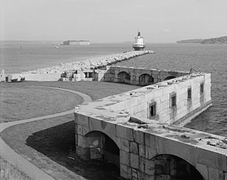
Fort Preble was a military fort in South Portland, Maine, United States, built in 1808 and progressively added to through 1906. The fort was active during all major wars from the War of 1812 through World War II. The fort was deactivated in 1950. It is now on the campus of Southern Maine Community College.

Beavertail State Park is a public recreation area encompassing 153 acres (62 ha) at the southern end of Conanicut Island in Narragansett Bay, Rhode Island. The state park's main attraction is the active Beavertail Lighthouse, the current tower of which dates from 1856. During World War II, the park area was part of Fort Burnside, one of several coastal fortifications designed to protect Narragansett Bay. The park's scenic shoreline offers hiking, picnicking, and saltwater fishing.

Fort Baldwin is a former coastal defense fortification near the mouth of the Kennebec River in Phippsburg, Maine, United States, preserved as the Fort Baldwin State Historic Site. It was named after Jeduthan Baldwin, an engineer for the Continental Army during the American Revolution. The site was listed on the National Register of Historic Places in 1979.

Fort Popham is a Civil War-era coastal defense fortification at the mouth of the Kennebec River in Phippsburg, Maine. It is located in sight of the short-lived Popham Colony and, like the colony, named for George Popham, the colony's leader. The site is preserved as Fort Popham State Historic Site.

Fort Funston is a former harbor defense installation located in the southwestern corner of San Francisco. Formerly known as the Lake Merced Military Reservation, the fort is now a protected area within the Golden Gate National Recreation Area (GGNRA) and is used widely as an off-leash dog park. It was named in honor of Frederick N. Funston (1865–1917), a Major General in the United States Army with strong connections to San Francisco, and included several artillery batteries. The fort is located on Skyline Boulevard at John Muir Drive, west of Lake Merced.
East Point Military Reservation was a World War I and World War II coastal defense site located in Nahant, Massachusetts. In 1955–62 it was a Nike missile launch site. In 1967 the site was converted into the Marine Science Center of Northeastern University.

Mishaum Point Military Reservation was a coastal defense site located in Dartmouth, Massachusetts as part of the Harbor Defenses of New Bedford.

Highlands Air Force Station was a military installation in Middletown Township near the borough of Highlands, New Jersey. The station provided ground-controlled interception radar coverage as part of the Lashup Radar Network and the Semi-Automatic Ground Environment network, as well as providing radar coverage for the Highlands Army Air Defense Site. The site's 240 acres (97 ha) is now the Rocky Point section in Hartshorne Woods Park of the Monmouth County Parks System.
Jewell Island is a small island in Casco Bay, Maine, United States. Approximately 1 mile (1.6 km) long from southwest to northeast, it is located off the coast of Cliff Island, approximately eight miles from downtown Portland. It is a state-owned island with a small but protected harbor as well as camping and walking paths. Jewell Island was part of the Harbor Defenses of Portland fort network. The island is part of the city of Portland. Jewell Island can be reached by private or charter boats. There is no ferry service to the island.

Halibut Point State Park and Halibut Point Reservation are adjacent parcels of conserved, oceanside land located on Cape Ann in the town of Rockport, Massachusetts. Once the Babson Farm granite quarry, the properties are cooperatively managed by the Trustees of Reservations and the Massachusetts Department of Conservation and Recreation . The adjacent Sea Rocks area is owned by the town of Rockport and is also open to the public.

Fort Williams is a former United States Army fort in Cape Elizabeth, Maine which operated from 1872 to 1964. It was part of the Coast Defenses of Portland, later renamed the Harbor Defenses of Portland, a command which protected Portland's port and naval anchorage 1904–1950. After its closure, it was redeveloped into Fort Williams Park.

Battery Steele is a United States military fortification on Peaks Island, Portland, Maine in Casco Bay. Completed in 1942 as part of World War II, it is located on 14 acres (5.7 ha) on the oceanside area of the island, formerly part of the Peaks Island Military Reservation. It is named for Harry L. Steele, who was a Coast Artillery officer during World War I. It was armed with two 16-inch MkIIMI guns and, with a 12-inch gun battery at Fort Levett on Cushing Island, replaced all previous heavy guns in the Harbor Defenses of Portland. It was built to protect Casco Bay, particularly Portland harbor, from Kennebunk to Popham Beach in Phippsburg. According to Kim MacIsaac and historian Joel Eastman in An Island at War, “Battery Steele is not only the largest gun battery built on Peaks Island, but also an example of the largest battery ever built anywhere in the United States.” In 1995, after decades of non-use, the Peaks Island Land Preserve, a community land preservation group, formed to purchase the area and forever preserve it as a public space. On October 20, 2005, the property was listed on the National Register of Historic Places. Other coast defense structures on the island include fire control towers and the counterweight for a disappearing searchlight tower.

Fort Church was a World War II United States Army coastal defense fort in Little Compton, Rhode Island. Together with Fort Greene near Point Judith, it superseded all previous heavy gun defenses in the Harbor Defenses of Narragansett Bay.
Fort Greene is a United States Army Reserve installation in the Point Judith area of Narragansett, Rhode Island. During World War II this was a coastal defense fort, and together with Fort Church in Little Compton, it superseded all previous heavy gun defenses in the Harbor Defenses of Narragansett Bay. It is named for General Nathanael Greene of the Revolutionary War, who was born in Rhode Island.

The Harbor Defenses of Portland was a United States Army Coast Artillery Corps harbor defense command. It coordinated the coast defenses of Portland, Maine, the mouth of the Kennebec River, and surrounding areas from 1895 to 1950, beginning with the Endicott program. These included both coast artillery forts and underwater minefields. The command originated circa 1895 as the Portland Artillery District, was renamed Coast Defenses of Portland in 1913, and again renamed Harbor Defenses of Portland in 1925.
The 240th Coast Artillery Regiment was a Coast Artillery Corps regiment in the Maine National Guard. It garrisoned the Harbor Defenses of Portland, Maine 1924–1944.


