
Hiram is a town in Oxford County, Maine, United States. The population was 1,609 at the 2020 census. It includes the villages of Hiram, East Hiram, South Hiram and Durgintown. Located among the rugged and unspoiled Western Maine Mountains, Hiram is part of the Portland-South Portland-Biddeford, Maine metropolitan New England city and town area.
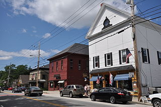
Cornish is a town in York County, Maine, United States. The population was 1,508 at the 2020 census. It is part of the Portland–South Portland–Biddeford, Maine metropolitan statistical area. The main village in town is the Cornish census-designated place. The village has a number of antique shops and restaurants near historic Thompson Park. Cornish is home to the first concrete bridge in North America.

Limington is a town in York County, Maine, United States. The population was 3,892 at the 2020 census. Limington is a tourist destination with historic architecture. It is part of the Portland–South Portland–Biddeford, Maine metropolitan statistical area.
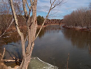
The Saco River is a river in northeastern New Hampshire and southwestern Maine in the United States. It drains a rural area of 1,703 square miles (4,410 km2) of forests and farmlands west and southwest of Portland, emptying into the Atlantic Ocean at Saco Bay, 136 miles (219 km) from its source. It supplies drinking water to roughly 250,000 people in thirty-five towns; and historically provided transportation and water power encouraging development of the cities of Biddeford and Saco and the towns of Fryeburg and Hiram.

The Ossipee River is an 18.3-mile-long (29.5 km) river in eastern New Hampshire and western Maine in the United States. It is a tributary of the Saco River, which flows southeast to the Atlantic Ocean at Saco, Maine.

Union is a village and census-designated place (CDP) in the town of Wakefield, Carroll County, New Hampshire, United States. It had a population of 196 at the 2020 census.

Sanbornville is a census-designated place (CDP) and the primary village in the town of Wakefield, Carroll County, New Hampshire, United States. It had a population of 963 at the 2020 census.

Steep Falls is a census-designated place (CDP) in the town of Standish in Cumberland County, Maine, United States. The population was 1,139 at the 2010 census. It is part of the Portland–South Portland–Biddeford, Maine Metropolitan Statistical Area. The town is part of Maine School Administrative District #6, which includes Bonny Eagle Middle and High Schools.
Center Ossipee is a census-designated place in the town of Ossipee in Carroll County, New Hampshire, United States. The population was 526 at the 2020 census. It is one of the two main villages in the town, the other being Ossipee Corner. Center Ossipee has a separate ZIP code (03814) from other portions of the town of Ossipee.
South Lansing is a census-designated place (CDP) in the town of Lansing, Tompkins County, New York, United States. The CDP includes the hamlets of South Lansing, Terpening Corners, and Asbury. The area was first listed as a CDP prior to the 2020 census.

Farmington is a census-designated place (CDP) comprising the center of the town of Farmington, which is the county seat of Franklin County in Maine, United States. The population of the CDP was 4,288 at the 2010 census, out of 7,760 people in the town as a whole. The University of Maine at Farmington is located within the CDP.

Freedom Plains is a hamlet and census-designated place (CDP) in Dutchess County, New York, United States. As of the 2010 census the population was 421.
Fort Covington is a census-designated place (CDP) within the town of Fort Covington, Franklin County, New York, United States. It consists of the hamlet of Fort Covington, as well as a large amount of rural land surrounding the hamlet, such that the CDP occupies about one half of the area within the town limits. The population of the CDP was 1,308 at the 2010 census, out of a total town population of 1,676.
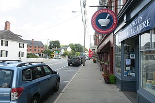
Alfred is a census-designated place (CDP) and the primary village in the town of Alfred, York County, Maine, United States. It is in central York County and the center of the town of Alfred, 4 miles (6 km) northeast of Sanford and 13 miles (21 km) west of Biddeford. U.S. Route 202 passes through the village, leading northeast 23 miles (37 km) to Gorham and southwest through Sanford 20 miles (32 km) to Rochester, New Hampshire. Maine State Route 4 leads south 13 miles (21 km) to North Berwick and leads north out of town with US 202. State Route 111 leads east from Alfred to Biddeford.
Madrid is the primary hamlet and a census-designated place (CDP) in the town of Madrid in St. Lawrence County, New York, United States. At the 2020 census, it had a population of 736, out of 1,735 in the entire town of Madrid.
Kingfield is a census-designated place (CDP) and the primary village in the town of Kingfield, Franklin County, Maine, United States. It is in the southeastern part of the town, along the Carrabassett River where it is joined by its West Branch. It is bordered partly to the south by the town of New Portland in Somerset County.
Bethel is a census-designated place (CDP) and the primary village in the town of Bethel, Oxford County, Maine, United States. It is situated in the southwestern part of the town, south of the Androscoggin River. U.S. Route 2 passes through the northwestern side of the CDP, leading northeast 23 miles (37 km) to Rumford and west 22 miles (35 km) to Gorham, New Hampshire. Maine State Route 5 joins Route 2 in Bethel but runs south through the village center and continues southwest 36 miles (58 km) to Fryeburg. State Route 26 leads southeast from Bethel 24 miles (39 km) to South Paris.
Corinna is a census-designated place (CDP) and the primary village in the town of Corinna, Penobscot County, Maine, United States. It is in the southern part of the town, on both sides of the East Branch Sebasticook River, part of the Kennebec River watershed.
Danforth is a census-designated place (CDP) and the primary village in the town of Danforth, Washington County, Maine, United States. It is in northernmost Washington County, in the northern part of the town of Danforth, and is bordered to the north by the town of Weston in Aroostook County. The village is located on Baskahegan Stream where it originates at the outlet of Crooked Brook Flowage. The Baskahegan is a northwest-flowing tributary of the Mattawamkeag River and part of the Penobscot River watershed.
South Berwick is a census-designated place (CDP) and the primary village in the town of South Berwick, York County, Maine, United States. It is in southwestern York County, in the northwestern corner of the town of South Berwick. It is bordered to the north by the town of Berwick, and to the southwest, across the Salmon Falls River, by the town of Rollinsford, New Hampshire.


