
Maine is the northernmost state in the New England region of the northeastern United States. Maine is the 12th smallest by area, the 9th least populous, and the 13th least densely populated of the 50 U.S. states. It is bordered by New Hampshire to the west, the Atlantic Ocean to the southeast, and the Canadian provinces of New Brunswick and Québec to the northeast and northwest, respectively. Maine is the only state to border just one other state, is the easternmost among the contiguous United States, and is the northernmost state east of the Great Lakes.

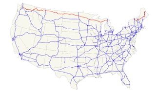
U.S. Route 1 or U.S. Highway 1 (US 1) is a major north–south United States Numbered Highway that serves the East Coast of the United States. It runs 2,369 miles (3,813 km), from Key West, Florida north to Fort Kent, Maine, at the Canadian border, making it the longest north–south road in the United States. US 1 is generally paralleled by Interstate 95 (I-95), though the former is significantly farther west (inland) between Jacksonville, Florida, and Petersburg, Virginia. The highway connects most of the major cities of the East Coast—including Miami, Jacksonville, Richmond, Washington, D.C., Baltimore, Philadelphia, New York City, and Boston passing from the Southeastern United States to New England.

York County is the southwesternmost county in the U.S. state of Maine, along the state of New Hampshire's eastern border. It is divided from Strafford County, New Hampshire, by the Salmon Falls River, and the connected tidal estuary—the Piscataqua River.
U.S. Route 2 or U.S. Highway 2 (US 2) is an east–west U.S. Highway spanning 2,571 miles (4,138 km) across the northern continental United States. US 2 consists of two segments connected by various roadways in southern Canada. Unlike some routes, which are disconnected into segments because of encroaching Interstate Highways, the two portions of US 2 were designed to be separate in the original 1926 highway plan.

The Canada–United States border, officially known as the International Boundary, is the longest international border in the world between two countries. It is shared between Canada and the United States, the second- and fourth- largest countries by area, respectively. The terrestrial boundary is 8,891 kilometres (5,525 mi) long, of which 2,475 kilometres (1,538 mi) is Canada's border with Alaska. Eight Canadian provinces and territories, and thirteen U.S. states are located along the border.
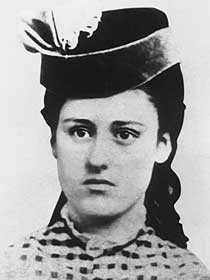
Grace Greenwood Bedell Billings was an American woman, notable as the person whose correspondence, at the age of eleven, encouraged Republican Party nominee and future president Abraham Lincoln to grow his iconic beard. Lincoln later met with Bedell during his inaugural journey in February 1861.

Maine's 1st congressional district is a congressional district in the U.S. state of Maine. The geographically smaller of the two congressional districts in the state, the district covers the southern coastal area of the state. The district consists of all of Cumberland, Knox, Lincoln, Sagadahoc and York counties and most of Kennebec County. Located within the district are the cities of Portland, Augusta, Brunswick and Saco.

Maine's 2nd congressional district is a congressional district in the U.S. state of Maine. Covering 27,326 square miles (70,770 km2), it comprises nearly 80% of the state's total land area. It is the largest district east of the Mississippi River and the 24th-largest overall. It is the second-most rural district in the United States, with 72.11% of its population in rural areas, behind only Kentucky's 5th congressional district.

Berkley Warren Bedell was an American Democratic Party politician and businessman who served as the U.S. Representative for Iowa's 6th congressional district from 1975 to 1987. After starting a successful business in his youth, Berkley Fly Co., he ran for Congress in 1972, but was defeated by incumbent Wiley Mayne. In 1974 however, Bedell beat Mayne and was elected to the U.S. House.
Iowa's 6th congressional district is a former congressional district in Iowa. It existed from 1862 to 1992, when it was lost due to Iowa's population growth rate being lower than that of the country as a whole.

The Bedell Bridge was a Burr truss covered bridge that spanned the Connecticut River between Newbury, Vermont and Haverhill, New Hampshire. Until its most recent destruction in 1979, it was, with a total length of 382 feet (116 m), the second-longest covered bridge in the United States. The bridge was divided into two spans of roughly equal length, and rested on a central pier and shore abutments constructed from mortared rough stone. The eastern abutment has been shored up by the addition of a concrete footing. The bridge was 23 feet (7.0 m) wide, with a roadway width of 18.5 feet (5.6 m). Because the state line is the western low-water mark of the Connecticut River, most of the bridge was in New Hampshire; only the western abutment is in Vermont.
The Campbell Branch Little Black River is a short river in Quebec (Canada) and northern Maine.
The North Branch Meduxnekeag River is a river in Aroostook County, Maine and Carleton County, New Brunswick. From the outlet of a small pond in Maine Township 8, Range 3, WELS, the river runs about 20 miles (30 km) northeast, south, and east to the Canada–United States border, crossing into Canada at 46°16′40″N67°46′56″W. It runs about 4 miles (6 km) southeast to its confluence with the Meduxnekeag River in Wakefield, NB.
The River De Chute is a river in Maine and New Brunswick. From the outflow of Lindsay Lake in Easton, Maine, the river runs about 5 miles (8 km) south, about half a mile west of the Canada–United States border. The river turns east and crosses into Canada at 46°36′04″N67°47′18″W. It runs about 3 miles (5 km) to its confluence with the Saint John River. This section of the river forms the border between Carleton County, New Brunswick and Victoria County, New Brunswick.
The Little Black River is a river flowing in the south of Quebec (Canada) and in the north of Maine.
The West Branch Pocwock Stream is a tributary of the Pocwock River flowing in:

Russell Crossing is an unincorporated village located within Northwest Aroostook, in Aroostook County, Maine.

Bedell is an hamlet in Delaware County, New York, United States.

