The Snake River is a major river in the interior Pacific Northwest region of the United States. About 1,080 miles (1,740 km) long, it is the largest tributary of the Columbia River, which is the largest North American river that empties into the Pacific Ocean. Beginning in Yellowstone National Park, western Wyoming, it flows across the arid Snake River Plain of southern Idaho, the rugged Hells Canyon on the borders of Idaho, Oregon and Washington, and finally the rolling Palouse Hills of southeast Washington. It joins the Columbia River just downstream from the Tri-Cities, Washington, in the southern Columbia Basin.

Matinicus Isle is an island plantation in Knox County, Maine, United States. The island is located within Penobscot Bay about 20 miles east of the mainland coast and is accessible by state ferry service from Rockland or by air taxi from Knox County Regional Airport. Matinicus is the inhabited land furthest off the American East Coast. The plantation is both a year-round island community and a summer colony. The population was 53 at the 2020 census.

Monhegan is an island in the Gulf of Maine. A plantation, a minor civil division in the state of Maine falling between unincorporated area and a town, it is located approximately 12 nautical miles (22 km) off the mainland and is part of Lincoln County, Maine, United States. The population was 64 at the 2020 census. The plantation comprises its namesake island and the neighboring island of Manana. The island is accessible by scheduled boat service from Boothbay Harbor, New Harbor and Port Clyde. Visitors' cars are not allowed on the island. It was designated a United States National Natural Landmark for its coastal and island flora in 1966.

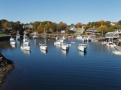
Ogunquit is a resort town in York County, Maine, United States. As of the 2020 census, its population was 1,577.
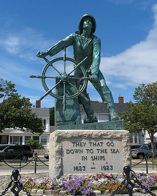
Gloucester is a city in Essex County, Massachusetts, United States. It sits on Cape Ann and is a part of Massachusetts's North Shore. The population was 29,729 at the 2020 U.S. Census. An important center of the fishing industry and a popular summer destination, Gloucester consists of an urban core on the north side of the harbor and the outlying neighborhoods of Annisquam, Bay View, Lanesville, Folly Cove, Magnolia, Riverdale, East Gloucester, and West Gloucester.

Mount Desert Island in Hancock County, Maine, is the largest island off the coast of Maine. With an area of 108 square miles (280 km2) it is the 52nd-largest island in the United States, the sixth-largest island in the contiguous United States, and the second-largest island on the Eastern Seaboard, behind Long Island and ahead of Martha's Vineyard. According to the 2010 census, the island has a year-round population of 10,615. In 2017, an estimated 3.5 million tourists visited Acadia National Park on MDI. The island is home to numerous well-known summer colonies such as Northeast Harbor and Bar Harbor.
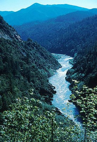
The Klamath River is a 257-mile (414 km) long river in southern Oregon and northern California. Beginning near Klamath Falls in the Oregon high desert, it flows west through the Cascade Range and Klamath Mountains before reaching the temperate rainforest of California's North Coast, where it empties into the Pacific Ocean. The Klamath River is the third-largest salmon and steelhead producing river on the west coast of the contiguous United States. The river's watershed – the Klamath Basin – encompasses more than 15,000 square miles (39,000 km2), and is known for its biodiverse forests, large areas of designated wilderness, and freshwater marshes that provide key migratory bird habitat.

The Kern River is an Endangered, Wild and Scenic river in the U.S. state of California, approximately 165 miles (270 km) long. It drains an area of the southern Sierra Nevada mountains northeast of Bakersfield. Fed by snowmelt near Mount Whitney, the river passes through scenic canyons in the mountains and is a popular destination for whitewater rafting and kayaking. It is the southernmost major river system in the Sierra Nevada, and is the only major river in the Sierra that drains in a southerly direction.

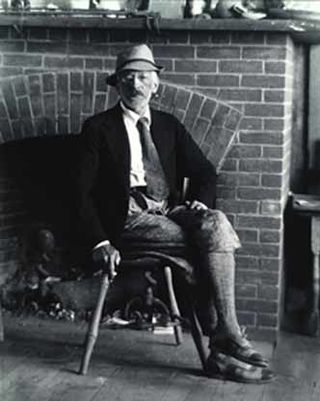
Robert Laurent was a French-American modernist figurative sculptor, printmaker and teacher. His work, the New York Times wrote,"figured in the development of an American sculptural art that balanced nature and abstraction." Widely exhibited, he took part in the Whitney's 1946 exhibition Pioneers of Modern Art. Credited as the first American sculptor to adopt a "direct carving" sculpting style that was bolder and more abstract than the then traditional fine arts practice, which relied on models, Laurent's approach was inspired by the African carving and European avant-garde art he admired, while also echoing folk styles found both in the U.S. and among medieval stone cutters of his native Brittany. Best known for his virtuoso mastery of the figure, Laurent sculpted in multiple media, including wood, alabaster, bronze, marble and aluminum. His expertise earned him major commissions for public sculpture, most famously for the Goose Girl for New York City's Radio City Music Hall, as well as for Spanning the Continent for Philadelphia's Fairmount Park. After the Depression, he was also the recipient of several Works Progress Administration (WPA) Federal Art Project commissions under the New Deal, including a bas-relief called Shipping for the exterior of Washington, D.C.'s Federal Trade Commission Building, commissioned by the Treasury Department's Section of Fine Arts in 1938.
Charles Herbert Woodbury, was an American marine painter.

Samuel Halpert was an American painter.
The Shepards River is a 13.6-mile-long (21.9 km) river in western Maine and eastern New Hampshire in the United States. It is part of the Saco River drainage basin.

The Presumpscot River is a 25.8-mile-long (41.5 km) river located in Cumberland County, Maine, United States. It is the main outlet of Sebago Lake. The river provided an early transportation corridor with reliable water power for industrial development of the city of Westbrook and the village of South Windham.

Odell Lake is located near Willamette Pass in the northwest corner of Klamath County, Oregon, United States. It is one of several lakes in the Cascade Range in Central Oregon, and lies within the Deschutes National Forest. It was named for Oregon Surveyor General William Holman Odell by Bynon J. Pengra, in July 1865, while they were making a preliminary survey for the Oregon Central Military Road, which would later become Oregon Route 58. The lake fills a basin carved by a glacier, and the resulting terminal moraine confines the water along the lake's southeast shore.

The Ogunquit Museum of American Art (OMAA) is an art museum located in Ogunquit, Maine. The Museum officially opened in 1953 and was founded by Lost Generation artist Henry Strater. Situated near Perkins Cove, the Museum and its three acres of sculpture gardens overlook Narrow Cove with views directly over the Atlantic Ocean. OMAA houses a permanent collection of over 3,000 paintings, sculptures, drawings, prints, and photographs spanning from the late 1800s to the present.
The Harraseeket River is a 3.2-mile-long (5.1 km) tidal river in the town of Freeport within the U.S. state of Maine. It forms a northern arm of Casco Bay.
The Josias River is a 2.7-mile-long (4.3 km) river in southern Maine in the United States. The river enters the Gulf of Maine in the town of Ogunquit where it and the Ogunquit River come together at Perkins Cove, a popular artist and tourist area.

Moody Beach is a coastal neighborhood and private beach located in Wells, Maine, with about 100 homes adjoining the beach. Moody Beach has a blend of year-round and summer residents, as well as short-term vacationers from around New England and Quebec. The coastline stretches about a mile long, from Ogunquit Beach to Moody Point on Ocean Avenue.
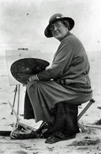
Mabel May Woodward was a prominent Rhode Island impressionist painter during the late 19th and early 20th century. She was active from 1896 until 1943, primarily in Rhode Island and in Maine.
Mountfort Coolidge (1888–1954) was an American landscape painter and antique dealer. He was born in Brooklyn, New York in 1888 and later moved to Ogunquit, Maine, where he resided for around forty years. His landscapes emphasize form and texture and have been described as Post-Impressionist or occasionally modernist in their approach.