
Ogunquit is a resort town in York County, Maine, United States. As of the 2020 census, its population was 1,577.

Wells is a resort town in York County, Maine, United States. Founded in 1643, it is the third-oldest town in Maine. The population was 11,314 at the 2020 census. Wells Beach is a popular summer destination.

The freedom to roam, or "everyman's right", is the general public's right to access certain public or privately owned land, lakes, and rivers for recreation and exercise. The right is sometimes called the right of public access to the wilderness or the "right to roam".
Riparian water rights is a system for allocating water among those who possess land along its path. It has its origins in English common law. Riparian water rights exist in many jurisdictions with a common law heritage, such as Canada, Australia, New Zealand, and states in the eastern United States.
Rollover Pass, also called Rollover Fish Pass, was a strait that linked Rollover Bay and East Bay with the Gulf of Mexico in extreme southeastern Galveston County. It has been closed by filling it in with dirt. Rollover Pass was opened in 1955 by the Texas Game and Fish Commission to improve local fishing conditions. Seawater was introduced into East Bay to promote vegetation growth, and to provide access for marine fish to spawn and feed. The name came from the days of Spanish rule, when barrels of merchandise would be rolled over that part of the peninsula to avoid excise tax. The Pass is about 1600 feet long and 200 feet wide.

The intertidal zone or foreshore is the area above water level at low tide and underwater at high tide: in other words, the part of the littoral zone within the tidal range. This area can include several types of habitats with various species of life, such as seastars, sea urchins, and many species of coral with regional differences in biodiversity. Sometimes it is referred to as the littoral zone or seashore, although those can be defined as a wider region.

The public trust doctrine is the principle that the sovereign holds in trust for public use some resources such as shoreline between the high and low tide lines, regardless of private property ownership.

The 1991 Perfect Storm, also known as The No-Name Storm and the Halloween Gale/Storm, was a damaging and deadly nor'easter in October 1991. Initially an extratropical cyclone, the storm absorbed Hurricane Grace to its south and evolved into a small unnamed hurricane later in its life. Damage from the storm totaled over $200 million and thirteen people were killed in total, six of which were an outcome of the sinking of Andrea Gail, which inspired the book and later movie, The Perfect Storm. The nor'easter received the name, playing off the common expression, after a conversation between Boston National Weather Service forecaster Robert Case and author Sebastian Junger.
Sears Island, known as Wassumkeag or shining beach by the indigenous Wabanaki tribes of northern New England, is located off the coast of Searsport in Waldo County, Maine, at the top of Penobscot Bay. The island is the largest undeveloped, uninhabited, causeway-accessible island on the eastern coast of the United States. It is 940 acres (3.8 km2) in area. It is part of the Town of Searsport.

The California Coastal Commission (CCC) is a state agency within the California Natural Resources Agency with quasi-judicial control of land and public access along the state's 1,100 miles (1,800 km) of coastline. Its mission as defined in the California Coastal Act is "to protect, conserve, restore, and enhance the environment of the California coastline".

The intellectual property rights on photographs are protected in different jurisdictions by the laws governing copyright and moral rights. In some cases photography may be restricted by civil or criminal law. Publishing certain photographs can be restricted by privacy or other laws. Photography can be generally restricted in the interests of public morality and the protection of children.
An easement is a nonpossessory right to use and/or enter onto the real property of another without possessing it. It is "best typified in the right of way which one landowner, A, may enjoy over the land of another, B". An easement is a property right and type of incorporeal property in itself at common law in most jurisdictions.
In United States law, littoral rights are rights concerning properties that abut static water like an ocean, bay, delta, sea or lake, rather than a flowing river or stream (riparian). Littoral rights are usually concerned with the use and enjoyment of the shore, but also may include rights to use the water similar to riparian rights.
The Oregon Beach Bill was a piece of landmark legislation in the U.S. state of Oregon, passed by the 1967 session of the Oregon Legislature. It established public ownership of land along the Oregon Coast from the water up to sixteen vertical feet above the low tide mark.
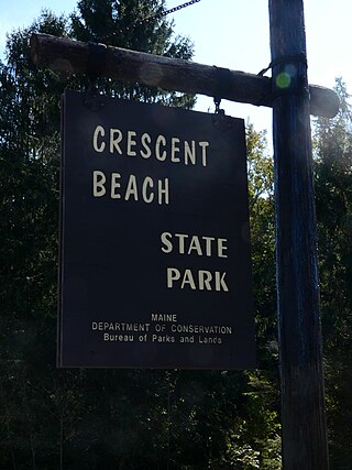
Crescent Beach State Park is public recreation area on the Atlantic Ocean in Cape Elizabeth, Maine, United States. The state park features a mile-long, crescent-shaped beach for swimming and sunbathing, fishing, sea kayaking, and trails for hiking and cross-country skiing.
In Nollan v. California Coastal Commission, 483 U.S. 825 (1987), the United States Supreme Court ruled that a California Coastal Commission regulation which required private homeowners to dedicate a public easement along valuable beachfront property as a condition of approval for a construction permit to renovate their beach bungalow was unconstitutional. The Coastal Commission had asserted that the public-easement condition was a legitimate state interest of diminishing the "blockage of the view of the ocean" caused by the home renovation, even though the easement wouldn't create any additional public view of the ocean. The Court held that in evaluating such claims, there must be an "essential nexus" between a legitimate state interest and the actual conditions of the permit being issued.
The Josias River is a 2.7-mile-long (4.3 km) river in southern Maine in the United States. The river enters the Gulf of Maine in the town of Ogunquit where it and the Ogunquit River come together at Perkins Cove, a popular artist and tourist area.
Right of way, is the legal right, established by grant from a landowner or long usage, to pass along a specific route through property belonging to another. A similar right of access also exists on land held by a government, lands that are typically called public land, state land, or Crown land. When one person owns a piece of land that is bordered on all sides by lands owned by others, an easement may exist or might be created so as to initiate a right of way through the bordering land.
In the United States, eminent domain is the power of a state or the federal government to take private property for public use while requiring just compensation to be given to the original owner. It can be legislatively delegated by the state to municipalities, government subdivisions, or even to private persons or corporations, when they are authorized to exercise the functions of public character.

Charles E. Wheeler Wildlife Management Area is a 625-acre (253 ha) brackish tidal marsh, nature preserve and hunting area owned by the state of Connecticut located in Devon (village), Milford, New Haven County, Connecticut.


