
South Berwick is a town in York County, Maine, United States. The population was 7,467 at the 2020 census. South Berwick is home to Berwick Academy, a private, co-educational university-preparatory day school founded in 1791.

Wakefield is a town in Carroll County, New Hampshire, United States. The population was 5,201 at the 2020 census. The town includes the villages of Wakefield Corner, East Wakefield, North Wakefield, Sanbornville, Union, Woodman and Province Lake. Wakefield Corner, popular with tourists, is a picturesque hilltop village of antique buildings. The state of Maine is on the eastern border of Wakefield.

Milton is a town in Strafford County, New Hampshire, United States. The population was 4,482 at the 2020 census. A manufacturing, resort and residential town, Milton includes the village of Milton Mills. The primary village in town, where 593 people resided at the 2020 census, is defined as the Milton census-designated place (CDP), and is located along New Hampshire Route 125 and the Salmon Falls River, just north of Route 75.

Rollinsford is a town in Strafford County, New Hampshire, United States. The population was 2,597 at the 2020 census. The main village in town was once known as "Salmon Falls Village".

Union is a village and census-designated place (CDP) in the town of Wakefield, Carroll County, New Hampshire, United States. It had a population of 196 at the 2020 census.

Sanbornville is a census-designated place (CDP) and the primary village in the town of Wakefield, Carroll County, New Hampshire, United States. It had a population of 963 at the 2020 census.

Milton Mills is a small village and census-designated place in the town of Milton, Strafford County, New Hampshire, United States. It had a population of 313 at the 2020 census. Milton Mills has a separate ZIP code (03852) from the rest of the town of Milton.

Steep Falls is a census-designated place (CDP) in the town of Standish in Cumberland County, Maine, United States. The population was 1,139 at the 2010 census. It is part of the Portland–South Portland–Biddeford, Maine Metropolitan Statistical Area. The town is part of Maine School Administrative District #6, which includes Bonny Eagle Middle and High Schools.

South Windham is a census-designated place (CDP) in the town of Windham in Cumberland County, Maine, United States. The population of the CDP was 1,374 at the 2010 census. Prior to 2010, South Windham was part of the Little Falls-South Windham census-designated place.
Winthrop is a hamlet and census-designated place (CDP) in the town of Stockholm in St. Lawrence County, New York, United States. As of the 2010 census, it had a population of 510.
Milton is a census-designated place (CDP) and the primary village in the town of Milton, Strafford County, New Hampshire, United States. The population of the CDP was 593 at the 2020 census, out of 4,482 in the entire town.

Little Falls is a census-designated place (CDP) in the town of Gorham in Cumberland County, Maine, United States. The population of the CDP was 708 at the 2010 census. Prior to 2010, Little Falls was part of the Little Falls-South Windham census-designated place.
Newcastle is a census-designated place (CDP) comprising the main village of the town of Newcastle in Lincoln County, Maine, United States. The population was 667 at the 2010 census, out of 1,752 in the entire town. In the 2000 census, the village was part of the Damariscotta-Newcastle CDP.
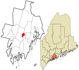
Berwick is a town in York County, Maine, United States, situated in the southern part of the state beside the Salmon Falls River.
Alfred is a census-designated place (CDP) and the primary village in the town of Alfred, York County, Maine, United States. It is in central York County and the center of the town of Alfred, 4 miles (6 km) northeast of Sanford and 13 miles (21 km) west of Biddeford. U.S. Route 202 passes through the village, leading northeast 23 miles (37 km) to Gorham and southwest through Sanford 20 miles (32 km) to Rochester, New Hampshire. Maine State Route 4 leads south 13 miles (21 km) to North Berwick and leads north out of town with US 202. State Route 111 leads east from Alfred to Biddeford.
Island Falls is a census-designated place (CDP) and the primary village in the town of Island Falls, Aroostook County, Maine, United States. It is in the northwest part of the town, situated on the West Branch Mattawamkeag River, part of the Penobscot River watershed. U.S. Route 2 passes through the village, leading northeast 27 miles (43 km) to Houlton and south 38 miles (61 km) to Mattawamkeag. Maine State Route 159 has its eastern terminus at U.S. 2 in the center of Island Falls and leads west 10 miles (16 km) to Patten. Interstate 95 passes just west of the village of Island Falls, with access from Exit 276 ; I-95 leads northeast to Houlton and southwest 92 miles (148 km) to Bangor.
Bethel is a census-designated place (CDP) and the primary village in the town of Bethel, Oxford County, Maine, United States. It is situated in the southwestern part of the town, south of the Androscoggin River. U.S. Route 2 passes through the northwestern side of the CDP, leading northeast 23 miles (37 km) to Rumford and west 22 miles (35 km) to Gorham, New Hampshire. Maine State Route 5 joins Route 2 in Bethel but runs south through the village center and continues southwest 36 miles (58 km) to Fryeburg. State Route 26 leads southeast from Bethel 24 miles (39 km) to South Paris.
Mattawamkeag is a census-designated place (CDP) and the primary village in the town of Mattawamkeag, Penobscot County, Maine, United States. It is in the southwestern corner of the town, where the Mattawamkeag River joins the Penobscot. The community is bordered to the south by the town of Winn and to the west, across the Penobscot, by the town of Woodville.
Patten is a census-designated place (CDP) and the primary village in the town of Patten, Penobscot County, Maine, United States. It is in the northeastern part of the town, mostly on the north side of Fish Stream, an eastward-flowing tributary of the West Branch Mattawamkeag River and part of the Penobscot River watershed.
Cornish is a census-designated place (CDP) and the primary village in the town of Cornish, York County, Maine, United States. It is on the northern border of York County, on the south side of the Ossipee River where it joins the Saco. To the north, across the Ossipee, is the town of Hiram in Oxford County, and to the east, across the Saco, is the town of Baldwin in Cumberland County.


