Litchfield, New Hampshire

Last updated

Litchfield, New Hampshire
Town
Aaron Cutler Memorial Library, Litchfield NH.jpg
Aaron Cutler Memorial Library
Litchfield, NH Town Flag.png
Town Seal of Litchfield, New Hampshire.png
Hillsborough-Litchfield-NH.png
Coordinates: 42°50′39″N71°28′47″W / 42.84417°N 71.47972°W / 42.84417; -71.47972
CountryUnited States
State New Hampshire
County Hillsborough
Incorporated 1734 in Massachusetts, 1749 in New Hampshire
Government
  Type Town Meeting (SB2)
   Board of Selectmen
  • F. Robert Leary, Chair
  • Steven Webber
  • G. Stephen Gannon
  • Kevin Lynch
  • Kim Queenan
  Town AdministratorKim Kleiner
Area
[1]
  Total15.31 sq mi (39.64 km2)
  Land14.92 sq mi (38.65 km2)
  Water0.38 sq mi (0.99 km2)  2.50%
Elevation
127 ft (39 m)
Population
 (2020) [2]
  Total8,478
  Density568/sq mi (219.3/km2)
Time zone UTC−5 (Eastern)
  Summer (DST) UTC−4 (Eastern)
ZIP code
03052
Area code 603
FIPS code 33-42260
GNIS feature ID0873648
Website litchfieldnh.gov

Litchfield is a town in Hillsborough County, New Hampshire, United States. The population was 8,478 at the 2020 census. [2]

Contents

History

Prior to European settlement, the area was populated by the Abenaki people. [3] They were skilled with fishing and were adept in agriculture as well. The New Hampshire Archaeological Society has located over 30 Native American sites along the shore of the Merrimack River in Litchfield, with artifacts several thousands of years old being uncovered. [4]

Extent of Old Dunstable (dashed line), which included much of modern-day Litchfield Map of old Dunstable 1846.png
Extent of Old Dunstable (dashed line), which included much of modern-day Litchfield

Most of Litchfield was part of the large town known as Dunstable, which was organized in the 1600s and included land along both sides of the disputed New Hampshire-Massachusetts boundary, and out of which were carved several towns and cities in both states. The area which became Litchfield was originally known as "Naticook". In 1656, William Brenton, colonial governor of Rhode Island, was granted land which included much of present-day Litchfield. [3] The name was changed to "Brenton's Farm" in 1729. The town was first incorporated into Massachusetts on July 4, 1734. [5] The first town meeting was held on Monday, July 29, 1734, at 1 pm at the house of Aquila Underwood to choose town officers. [6] In 1749, the land was granted to another group of settlers and named "Litchfield" after George Henry Lee, Earl of Lichfield. Litchfield was incorporated into the Province of New Hampshire on June 5, 1749. [5]

Litchfield lacks any major population center or central village. Historically farmland, the town experienced steep population growth starting in the 1970s, along with the rest of southern New Hampshire, as a bedroom community and exurb for Greater Boston. The original town hall was located along New Hampshire Route 3A in the east-central portion of the town; the current town hall lies at the town's geographic center at the intersection of Hillcrest Road and Albuquerque Avenue. There are no large commercial districts in the town, though a few small industrial parks, convenience stores, and small restaurants dot the landscape. [7]

On December 12, 1991, a cross burning took place in Litchfield, but no one was hurt. In 1995, Russell Trim was arrested and charged with the crime. [8] [7]

Geography

According to the United States Census Bureau, the town has a total area of 15.3 square miles (39.6 km2), of which 14.9 square miles (38.7 km2) are land and 0.4 square miles (1.0 km2) is water, comprising 2.50% of the town. [1] The highest point in Litchfield is the summit of Rocky Hill, near the center of town in Litchfield State Forest, at 357 feet (109 m) above sea level. The town is bordered to the north by Manchester, to the east by Londonderry in Rockingham County, to the south by Hudson, to the west by Merrimack, and to the extreme southwest by Nashua, with the Merrimack River separating Litchfield from both Merrimack and Nashua. There is no bridge connecting Litchfield and Merrimack; the closest river crossings are to the south between Nashua and Hudson, and to the north between Manchester and Bedford.

There are two islands in the Merrimack River within the borders of Litchfield. The islands have been called "Minnewawa" and "Nunnehaha", the Naticook Islands, and Reed's Islands. [9] [10] The northern island is located within Litchfield, while the southern island is essentially split down the middle by the boundary between Litchfield and Merrimack, forming the only land border between the two towns. [11] Merrimack owns both islands. [11]

Adjacent municipalities

Demographics

Historical population
CensusPop.Note
1790 357
1800 3724.2%
1810 3822.7%
1820 46521.7%
1830 5058.6%
1840 481−4.8%
1850 447−7.1%
1860 352−21.3%
1870 345−2.0%
1880 291−15.7%
1890 252−13.4%
1900 243−3.6%
1910 2554.9%
1920 213−16.5%
1930 28634.3%
1940 34119.2%
1950 42725.2%
1960 72168.9%
1970 1,42096.9%
1980 4,150192.3%
1990 5,51632.9%
2000 7,36033.4%
2010 8,27112.4%
2020 8,4782.5%
U.S. Decennial Census [2] [12]

As of the census [13] of 2000, there were 7,360 people, 2,357 households, and 2,031 families residing in the town. The population density was 487.5 inhabitants per square mile (188.2/km2). There were 2,389 housing units at an average density of 158.3 per square mile (61.1/km2). The racial makeup of the town was 97.72% White, 0.53% African American, 0.29% Native American, 0.57% Asian, 0.15% from other races, and 0.75% from two or more races. Hispanic or Latino of any race were 0.83% of the population.

There were 2,357 households, out of which 53.4% had children under the age of 18 living with them, 75.3% were married couples living together, 7.4% had a female householder with no husband present, and 13.8% were non-families. 9.5% of all households were made up of individuals, and 1.4% had someone living alone who was 65 years of age or older. The average household size was 3.12 and the average family size was 3.35.

In the town, the population was spread out, with 33.4% under the age of 18, 5.4% from 18 to 24, 37.8% from 25 to 44, 19.9% from 45 to 64, and 3.5% who were 65 years of age or older. The median age was 33 years. For every 100 females, there were 101.1 males. For every 100 females age 18 and over, there were 98.1 males.

The median income for a household in the town was $73,302, and the median income for a family was $76,931. Males had a median income of $46,809 versus $33,488 for females. The per capita income for the town was $25,203. About 2.2% of families and 2.1% of the population were below the poverty line, including 1.6% of those under age 18 and 12.1% of those age 65 or over.

Education

There are three public schools in Litchfield:

Transportation

Two New Hampshire state highways cross Litchfield:

Though the town borders Merrimack on the west, it cannot be directly accessed as there are no bridges across the river. Access to Londonderry, to the east of Litchfield, is primarily via Hillcrest Road, which is the main east-west thoroughfare across central Litchfield.

Litchfield has no air or rail transport within the town limits. The nearest commercial airport is Manchester–Boston Regional Airport along the border of Londonderry and Manchester, which is close to the northern border of Litchfield. The nearest rail service is the Lowell Line of the MBTA Commuter Rail system, which can be accessed at the Charles A. Gallagher Transit Terminal in Lowell, Massachusetts. The nearest Amtrak stations are Boston's North Station or South Station. There was a trolley that ran through Litchfield in the early 20th century, but it was long since discontinued and fallen into disrepair. There are few remnants left, including a portion of rail trail and a dilapidated trolley bridge within Parker Park.

Government and municipal services

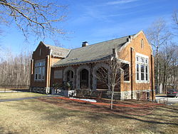
The town of Litchfield operates a waste management and transfer station on Hillcrest Road, located near the geographical center of Litchfield and the "new" town hall, police and fire station. The historical center of Litchfield is on the Charles Bancroft Highway (New Hampshire Route 3A). Today the first church in Litchfield, the Litchfield Community Television studio, and the Litchfield Historical Society are located there in and around the old town hall and fire station. The town's new fire station opened on Liberty Way in May 2019. [14]

A trail in a conservation area in Litchfield Birch Street.jpg
A trail in a conservation area in Litchfield

Several public parks, including Roy Memorial Park and the Litchfield State Forest, are open year-round to the public. Municipal parks are managed by the Litchfield Recreation Commission. The state forest is managed by the New Hampshire Department of Natural and Cultural Resources, among other agencies.

The Litchfield Mosquito Control District was featured on Last Week Tonight with John Oliver . The episode featured segments from a televised town meeting from September 17, 2015, which had no members of the public in attendance. [15] [16]

The town has several conservation areas, including Moore's Falls, Parker Park, and Stage Crossing. The Litchfield Conservation Commission holds the responsibility of managing these lands for the preservation and proper utilization of natural resources in town.

Notable people

Related Research Articles

<span class="mw-page-title-main">Hillsborough County, New Hampshire</span> County in New Hampshire, United States

Hillsborough County is the most populous county in the U.S. state of New Hampshire. As of the 2020 census, the population was 422,937, almost one-third the population of the entire state. Its county seats are Manchester and Nashua, the state's two biggest cities. Hillsborough is northern New England's most populous county as well as its most densely populated.

<span class="mw-page-title-main">Amherst, New Hampshire</span> Town in New Hampshire, United States

Amherst is a town in Hillsborough County in the state of New Hampshire, United States. The population was 11,753 at the 2020 census. Amherst is home to Ponemah Bog Wildlife Sanctuary, Hodgman State Forest, the Joe English Reservation and Baboosic Lake.

<span class="mw-page-title-main">Brookline, New Hampshire</span> Town in New Hampshire, United States

Brookline is a town in Hillsborough County, New Hampshire, United States. The population was 5,639 at the 2020 census, up from 4,991 at the 2010 census. Brookline is home to the Talbot-Taylor Wildlife Sanctuary, Potanipo Pond, and the Brookline Covered Bridge.

<span class="mw-page-title-main">Deering, New Hampshire</span> Town in New Hampshire, United States

Deering is a town in Hillsborough County, New Hampshire, United States. The population was 1,904 at the 2020 census.

<span class="mw-page-title-main">East Merrimack, New Hampshire</span> Census-designated place in New Hampshire, United States

East Merrimack is a census-designated place (CDP) in the town of Merrimack, Hillsborough County, New Hampshire, United States. There is no village center named "East Merrimack"; rather, the CDP refers to the region of the town of Merrimack lying east of the F. E. Everett Turnpike, overlapping portions of the villages of Reeds Ferry, Thornton's Ferry, and the center of Merrimack. The population was 5,176 at the 2020 census, up from 4,197 at the 2010 census.

<span class="mw-page-title-main">Hollis, New Hampshire</span> Town in New Hampshire, United States

Hollis is a town in Hillsborough County, New Hampshire, United States. The population was 8,342 at the 2020 census, having grown 9% from the 2010 population of 7,684. The town center village is listed on the National Register of Historic Places as Hollis Village Historic District.

<span class="mw-page-title-main">Merrimack, New Hampshire</span> Town in New Hampshire, United States

Merrimack is a town in Hillsborough County, New Hampshire, United States. The population was 26,632 as of the 2020 census.

<span class="mw-page-title-main">Nashua, New Hampshire</span> City in New Hampshire, United States

Nashua is a city in southern New Hampshire, United States. As of the 2020 census, it had a population of 91,322, the second-largest in northern New England after nearby Manchester. Along with Manchester, it is a seat of New Hampshire's most populous county, Hillsborough.

<span class="mw-page-title-main">Pelham, New Hampshire</span> Town in New Hampshire, United States

Pelham is a town in Hillsborough County, New Hampshire, United States. The population was 14,222 at the 2020 census, up from 12,897 at the 2010 census.

<span class="mw-page-title-main">Hudson (CDP), New Hampshire</span> Census-designated place in New Hampshire, United States

Hudson is a census-designated place (CDP) and the urban center of the town of Hudson in Hillsborough County, New Hampshire, United States. The population of the CDP was 7,534 at the 2020 census, out of 25,394 in the entire town.

<span class="mw-page-title-main">Hooksett, New Hampshire</span> Town in New Hampshire, United States

Hooksett is a town in Merrimack County, New Hampshire, United States. The population was 14,871 at the 2020 census, up from 13,451 at the 2010 census. The town is located between Manchester, the state's largest city, and Concord, the state capital. A prominent landmark is Robie's Country Store, a National Historic Landmark and a frequent stop for presidential candidates during the New Hampshire primary.

<span class="mw-page-title-main">Derry (CDP), New Hampshire</span> Census-designated place in New Hampshire, United States

Derry is a census-designated place (CDP) in the town of Derry in Rockingham County, New Hampshire, United States. The CDP comprises the urban center of the town, as well as the village of East Derry and connected suburban areas. The population of the CDP was 22,879 at the 2020 census, out of 34,317 in the entire town.

<span class="mw-page-title-main">Londonderry (CDP), New Hampshire</span> Census-designated place in New Hampshire, United States

Londonderry is a census-designated place (CDP) within the town of Londonderry in Rockingham County, New Hampshire, United States. The population of the CDP was 11,645 at the 2020 census, out of 25,826 in the entire town.

<span class="mw-page-title-main">Londonderry, New Hampshire</span> Town in Rockingham County, New Hampshire, United States of America

Londonderry is a town in western Rockingham County, New Hampshire, United States. It sits between Manchester and Derry, the largest and fourth-largest communities in the state. The population was 25,826 at the 2020 census. Londonderry is known for its apple orchards and is home to the headquarters of Stonyfield Farm and part of Manchester–Boston Regional Airport.

<span class="mw-page-title-main">Derry, New Hampshire</span> Town in New Hampshire, United States

Derry is a town in Rockingham County, New Hampshire, United States. The population was 34,317 at the 2020 census. Although it is a town and not a city, Derry is the most populous community in Rockingham County and the 4th most populous in the state. The town's nickname, "Spacetown", derives from the fact that Derry is the birthplace of Alan Shepard, the first astronaut from the United States in space. Derry was also for a time the home of the poet Robert Frost and his family.

<span class="mw-page-title-main">Hudson, New Hampshire</span> Town in New Hampshire, United States

Hudson is a town in Hillsborough County, New Hampshire, United States. It is located along the Massachusetts state line. The population was 25,394 at the 2020 census. It is the tenth-largest municipality in the state, by population.

<span class="mw-page-title-main">Dunstable, New Hampshire</span>

Dunstable, New Hampshire was a town located in Hillsborough County, New Hampshire. It has been divided into several current cities and towns, including Nashua, Hollis, Hudson, Litchfield, and Merrimack.

<span class="mw-page-title-main">Merrimack Valley</span> Region in the U.S. states of New Hampshire and Massachusetts

The Merrimack Valley is a bi-state region along the Merrimack River in the U.S. states of New Hampshire and Massachusetts. The Merrimack is one of the larger waterways in New England and has helped to define the livelihood and culture of those living along it for millennia.

<span class="mw-page-title-main">Nashville Historic District (Nashua, New Hampshire)</span> Historic district and former town in New Hampshire, United States

The Nashville Historic District in Nashua, New Hampshire is a historic district that was listed on the National Register of Historic Places (NRHP) in 1984. It encompasses an area just north of downtown Nashua, roughly centered on the junction of Concord, Amherst, and Main streets. Its southern bound is the Nashua River and Railroad Square, its eastern bounds are Railroad Square, Clinton, Lock, Orange, and Concord streets, its northern bound is Mount Pleasant Street, and its western boundary is Abbott, Amherst, Concord, and Main streets between the northern and southern bounds.

<span class="mw-page-title-main">2020 New Hampshire Executive Council election</span>

The 2020 New Hampshire Executive Council elections took place on Tuesday, November 3, 2020, to elect all five members of the Executive Council of New Hampshire. The party primaries were held on September 8.

References

  1. 1 2 "2021 U.S. Gazetteer Files – New Hampshire". United States Census Bureau. Retrieved December 8, 2021.
  2. 1 2 3 "Litchfield town, Hillsborough County, New Hampshire: 2020 DEC Redistricting Data (PL 94-171)". U.S. Census Bureau. Retrieved December 8, 2021.
  3. 1 2 Fox, Charles J. (Charles James) (1846). History of the Old Township of Dunstable: Including Nashua, Nashville, Hollis, Hudson, Litchfield, and Merrimac, N.H.; Dunstable and Tyngsborough, Mass. The Library of Congress. Nashua, C. T. Gill.
  4. "Chapter VII: Historic Resources" (PDF). Town of Litchfield Master Plan. 2002. Retrieved May 14, 2018.
  5. 1 2 Hurd, D. Hamilton (1885). History of Hillsborough County, New Hampshire. University of Chicago Libraries. J.W. Lewis & Co. pp.  490–491. Aquila Underwood
  6. Hurd, Duane Hamilton (1885). History of Hillsborough County, New Hampshire. J. W. Lewis & Company. p.  540. Aquila Underwood
  7. 1 2 "Annual report of the Town of Litchfield, New Hampshire". 1995. Retrieved January 3, 2023.
  8. Staff. "Suspect Charged with Burning Cross on Lawn". Buffalo News. Retrieved January 3, 2023.
  9. "A Brief History of Merrimack, New Hampshire". Merrimack Historical Society. Retrieved November 5, 2018.
  10. "The Lower Merrimack River" (PDF). NH Department of Environmental Services. 2016. Archived (PDF) from the original on April 13, 2009. Retrieved November 5, 2018.
  11. 1 2 "NRPC GIS Map". Nashua Regional Planning Commission. Retrieved November 5, 2018.
  12. "Census of Population and Housing". Census.gov. Retrieved June 4, 2016.
  13. "U.S. Census website". United States Census Bureau . Retrieved January 31, 2008.
  14. Houghton, Kimberly (May 6, 2019). "Opening the doors to Litchfield's new fire station". New Hampshire Union Leader. Retrieved August 2, 2019.
  15. John Oliver (March 6, 2016). Special Districts: Last Week Tonight with John Oliver (HBO) (Video) (YouTube). New York: HBO. Event occurs at 4:06. Archived from the original on December 11, 2021. Retrieved June 4, 2017.
  16. Mosquito Control District Meeting - Sept 17, 2015 (Video) (YouTube). Litchfield, New Hampshire: LitchfieldTV. September 17, 2015. Archived from the original on December 11, 2021. Retrieved June 4, 2017.
  17. "CLAGETT, Clifton, (1762 - 1829)". Biographical Directory of the United States Congress. Retrieved January 19, 2014.
  18. Leroy N. McQuesten, Recollections of Leroy N. McQuesten of life in the Yukon, 1871-1885 (1952).
  19. "Spotlight On...Jennifer Simard". www.theaterinthenow.com. Retrieved October 21, 2018.