Francestown (CDP), New Hampshire

Last updated
Francestown, New Hampshire
Francestown CDP Oct 2021.jpg
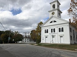
Francestown Meetinghouse in the village center
USA New Hampshire location map.svg
Red pog.svg
Francestown
Usa edcp location map.svg
Red pog.svg
Francestown
Coordinates: 42°59′15″N71°48′45″W / 42.98750°N 71.81250°W / 42.98750; -71.81250 Coordinates: 42°59′15″N71°48′45″W / 42.98750°N 71.81250°W / 42.98750; -71.81250
Country United States
State New Hampshire
County Hillsborough
Town Francestown
Area
[1]
  Total0.94 sq mi (2.43 km2)
  Land0.94 sq mi (2.43 km2)
  Water0.00 sq mi (0.00 km2)
Elevation
830 ft (250 m)
Population
 (2020)
  Total201
  Density214.29/sq mi (82.78/km2)
Time zone UTC-5 (Eastern (EST))
  Summer (DST) UTC-4 (EDT)
ZIP code
03043
Area code 603
FIPS code 33-27060
GNIS feature ID2806679

Francestown is a census-designated place (CDP) and the main village in the town of Francestown, Hillsborough County, New Hampshire, United States. As of the 2020 census, the population of the CDP was 201, [2] out of 1,610 in the entire town.

Contents

Geography

The CDP is in the center of the town of Francestown and extends west as far as Perley Road, north past Hiram Patch Lane, northeast to Todd Road, east past Potash Road, south to Old County Road South, and southwest to Champagne Road. [3] The Francestown Town Hall and Academy and Town Common Historic District occupies the center of the CDP.

New Hampshire Route 136 passes through the center of the community, leading east 7 miles (11 km) to New Boston and southwest 4 miles (6 km) to Greenfield. New Hampshire Route 47 has its southern terminus in Francestown and leads northwest 7 miles (11 km) to Bennington. Second New Hampshire Turnpike, a local road, leads southeast 9 miles (14 km) to Mont Vernon.

According to the U.S. Census Bureau, the Francestown CDP has a total area of 0.93 square miles (2.4 km2), all of it recorded as land. [4] The South Branch Piscataquog River, here a large brook, runs through the east side of the CDP and is part of the Merrimack River watershed.

Demographics

Historical population
CensusPop.
2020 201
U.S. Decennial Census [5]

Related Research Articles

<span class="mw-page-title-main">Contoocook, New Hampshire</span> Census-designated place in New Hampshire, United States

Contoocook is a village and census-designated place (CDP) within the town of Hopkinton in Merrimack County, New Hampshire, United States. The population was 1,427 at the 2020 census. Contoocook is well known for its growth of small businesses, preservation of historical landmarks, community involvement and recreational activities within the village.

Meredith is a census-designated place (CDP) and the main village in the town of Meredith in Belknap County, New Hampshire, United States. The population was 2,527 at the 2020 census, out of 6,662 in the entire town of Meredith.

Winchester is a census-designated place (CDP) and the main village in the town of Winchester in Cheshire County, New Hampshire, United States. The population of the CDP was 1,606 at the 2020 census, compared to 4,150 in the entire town.

Whitefield is a census-designated place (CDP) and the main village in the town of Whitefield in Coos County, New Hampshire, United States. The population of the CDP was 1,460 at the 2020 census, out of 2,490 people in the entire town of Whitefield.

<span class="mw-page-title-main">Bristol (CDP), New Hampshire</span> Census-designated place in New Hampshire, United States

Bristol is a census-designated place (CDP) and the main village in the town of Bristol in Grafton County, New Hampshire, United States. The population of the CDP was 1,911 at the 2020 census, out of 3,244 in the entire town.

Littleton is a census-designated place (CDP) and the main village in the town of Littleton in Grafton County, New Hampshire, United States. The population of the CDP was 4,467 at the 2020 census, out of 6,005 in the entire town.

<span class="mw-page-title-main">Greenville (CDP), New Hampshire</span> Census-designated place in New Hampshire, United States

Greenville is a census-designated place (CDP) and the main village in the town of Greenville in Hillsborough County, New Hampshire, United States. The population of the CDP was 1,074 at the 2020 census, out of 1,974 in the entire town.

Derry is a census-designated place (CDP) in the town of Derry in Rockingham County, New Hampshire, United States. The CDP comprises the urban center of the town, as well as the village of East Derry and connected suburban areas. The population of the CDP was 22,879 at the 2020 census, out of 34,317 in the entire town.

Exeter is a census-designated place (CDP) and the main village in the town of Exeter, Rockingham County, New Hampshire, United States. The population of the CDP was 10,109 at the 2020 census, out of 16,049 in the entire town.

Londonderry is a census-designated place (CDP) within the town of Londonderry in Rockingham County, New Hampshire, United States. The population of the CDP was 11,645 at the 2020 census, out of 25,826 in the entire town.

<span class="mw-page-title-main">Raymond (CDP), New Hampshire</span> Census-designated place in New Hampshire, United States

Raymond is a census-designated place (CDP) and the main village in the town of Raymond, Rockingham County, New Hampshire, United States. The population of the CDP was 3,738 at the 2020 census, out of 10,684 in the entire town.

Newport is a census-designated place (CDP) comprising the main village and surrounding rural land in the town of Newport, Sullivan County, New Hampshire, United States. The population of the CDP was 4,735 at the 2020 census, out of 6,299 in the entire town.

<span class="mw-page-title-main">Center Sandwich, New Hampshire</span> Census-designated place in New Hampshire, United States

Center Sandwich is a census-designated place in the town of Sandwich in Carroll County, New Hampshire, in the United States. It is the primary settlement in the town and had a population of 156 at the 2020 census. The village center and surrounding area are listed on the National Register of Historic Places as the Center Sandwich Historic District.

Alton is a census-designated place (CDP) and the main village in the town of Alton in Belknap County, New Hampshire, United States. The population was 499 at the 2020 census, compared to 5,894 in the entire town of Alton.

<span class="mw-page-title-main">Belmont (CDP), New Hampshire</span> Census-designated place in New Hampshire, United States

Belmont is a census-designated place (CDP) and the main village in the town of Belmont in Belknap County, New Hampshire, United States. The population was 1,285 at the 2020 census, out of 7,314 in the entire town of Belmont.

<span class="mw-page-title-main">Goffstown (CDP), New Hampshire</span> Census-designated place in New Hampshire, United States

Goffstown is a census-designated place (CDP) and the main village in the town of Goffstown in Hillsborough County, New Hampshire, United States. The population of the CDP was 3,366 at the 2020 census, out of 18,577 in the entire town.

<span class="mw-page-title-main">Bennington (CDP), New Hampshire</span> Census-designated place in New Hampshire, United States

Bennington is a census-designated place (CDP) and the main village in the town of Bennington in Hillsborough County, New Hampshire, United States. The population of the CDP was 338 at the 2020 census, out of 1,501 in the entire town.

<span class="mw-page-title-main">Hancock (CDP), New Hampshire</span> Census-designated place in New Hampshire, United States

Hancock is a census-designated place (CDP) and the main village in the town of Hancock in Hillsborough County, New Hampshire, United States. The population of the CDP was 213 at the 2020 census, out of 1,731 in the entire town.

<span class="mw-page-title-main">Walpole (CDP), New Hampshire</span> Census-designated place in New Hampshire, United States

Walpole is a census-designated place (CDP) and the central village in the town of Walpole in Cheshire County, New Hampshire, United States. The population of the CDP was 573 at the 2020 census, compared to 3,633 in the entire town.

New Boston is a census-designated place (CDP) comprising the main village in the town of New Boston, Hillsborough County, New Hampshire, United States. As of the 2020 census, the population of the CDP was 326, out of 6,108 in the entire town.

References

  1. "ArcGIS REST Services Directory". United States Census Bureau. Retrieved September 20, 2022.
  2. "Francestown CDP, New Hampshire: 2020 DEC Redistricting Data (PL 94-171)". U.S. Census Bureau. Retrieved December 10, 2021.
  3. "TIGERweb: Francestown CDP, New Hampshire". Geography Division, U.S. Census Bureau. Retrieved February 12, 2021.
  4. "2020 U.S. Gazetteer Files: New Hampshire". United States Census Bureau. Retrieved February 11, 2021.
  5. "Census of Population and Housing". Census.gov. Retrieved June 4, 2016.