| West Peterborough, New Hampshire | |
|---|---|
| Unincorporated community | |
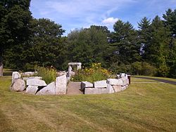
Teixeira Park | |
 West Peterborough  West Peterborough | |
| Coordinates: 42°53′12″N71°59′05″W / 42.88667°N 71.98472°W Coordinates: 42°53′12″N71°59′05″W / 42.88667°N 71.98472°W | |
| Country | United States |
| State | New Hampshire |
| County | Hillsborough |
| Town | Peterborough |
| Elevation | 863 ft (263 m) |
| Time zone | Eastern (EST) (UTC-5) |
| • Summer (DST) | EDT (UTC-4) |
| ZIP code | 03468 |
| Area code(s) | 603 |
| GNIS feature ID | 870786 [1] |
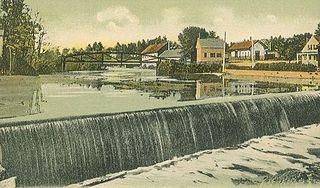
West Peterborough is an unincorporated community in the town of Peterborough in Hillsborough County, New Hampshire, United States. It is located along Nubanusit Brook in the western part of the town. Union Street leads 2 miles (3 km) east to the Peterborough town center and 0.6 miles (1.0 km) south to New Hampshire Route 101, a highway connecting Keene to the west with Milford to the east.

In law, an unincorporated area is a region of land that is not governed by a local municipal corporation; similarly an unincorporated community is a settlement that is not governed by its own local municipal corporation, but rather is administered as part of larger administrative divisions, such as a township, parish, borough, county, city, canton, state, province or country. Occasionally, municipalities dissolve or disincorporate, which may happen if they become fiscally insolvent, and services become the responsibility of a higher administration. Widespread unincorporated communities and areas are a distinguishing feature of the United States and Canada. In most other countries of the world, there are either no unincorporated areas at all, or these are very rare; typically remote, outlying, sparsely populated or uninhabited areas.

Peterborough is a town in Hillsborough County, New Hampshire, United States. The population was 6,284 at the 2010 census. The central settlement in town, with 3,103 people at the 2010 census, is defined as the Peterborough census-designated place (CDP) and is located along the Contoocook River at the junction of U.S. Route 202 and New Hampshire Route 101. The community is 38 miles (61 km) west of Manchester and 72 miles (116 km) northwest of Boston.
Hillsborough County is the most populous county in the U.S. state of New Hampshire. As of the 2010 census, the population was 400,721. The population was estimated at 407,761 in 2016. Its county seats are Manchester and Nashua. Hillsborough is northern New England's most populous county as well as its most densely populated. Hillsborough County comprises the Manchester-Nashua, NH Metropolitan Statistical Area, which in turn constitutes a portion of the Boston-Worcester-Providence, MA-RI-NH-CT Combined Statistical Area.
West Peterborough has a separate ZIP code (03468) from the rest of Peterborough. The community's population, however, is included in the Peterborough census-designated place, comprising the central settled area of the town.

Peterborough is a census-designated place (CDP) and the main village in the town of Peterborough in Hillsborough County, New Hampshire, United States. The population of the CDP was 3,103 at the 2010 census, out of 6,284 people in the entire town of Peterborough.