
Cochituate is a census-designated place (CDP) in the town of Wayland in Middlesex County, Massachusetts, United States. The population was 6,927 at the 2020 census, out of 13,943 in the entire town of Wayland.

Framingham is a city in the Commonwealth of Massachusetts, United States. Incorporated in 1700, it is located in Middlesex County and the MetroWest subregion of the Greater Boston metropolitan area. The city proper covers 25 square miles (65 km2) with a population of 72,362 in 2020, making it the 14th most populous municipality in Massachusetts. Residents voted in favor of adopting a charter to transition from a representative town meeting system to a mayor–council government in April 2017, and the municipality transitioned to city status on January 1, 2018. Before it transitioned, it had been the largest town by population in Massachusetts.

The Quabbin Reservoir is the largest inland body of water in Massachusetts, United States, and was built between 1930 and 1939. Along with the Wachusett Reservoir, it is the primary water supply for Boston, 65 miles (105 km) to the east, and 40 other cities and towns in Greater Boston. The Quabbin also supplies water to three towns west of the reservoir and acts as backup supply for three others. By 1989, it supplied water for 2.5 million people, about 40% of the state's population at the time. It has an aggregate capacity of 412 billion US gallons (1,560 GL) and an area of 38.6 square miles (99.9 km2).

The Massachusetts Water Resources Authority (MWRA) is a public authority in the Commonwealth of Massachusetts that provides wholesale drinking water and sewage services to 3.1 million people in sixty-one municipalities and more than 5,500 large industrial users in the eastern and central parts of the state, primarily in the Boston area.

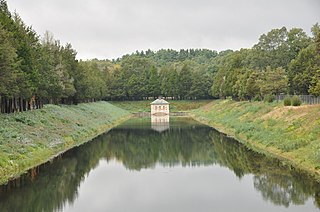
Chestnut Hill is a wealthy New England village located six miles (10 km) west of downtown Boston, Massachusetts, United States. It is best known for being home to Boston College and a section of the Boston Marathon route. Like all Massachusetts villages, Chestnut Hill is not an incorporated municipal entity. It is located partially in Brookline in Norfolk County; partially in the city of Boston in Suffolk County, and partially in the city of Newton in Middlesex County. Chestnut Hill's borders are defined by the 02467 ZIP Code. The name refers to several small hills that overlook the 135-acre Chestnut Hill Reservoir rather than one particular hill.

Boston and Worcester Electric Companies (B&W) was a holding company for several streetcar companies between Boston and Worcester, Massachusetts. The main line, built by the Boston and Worcester Street Railway, was an interurban streetcar line partly on the old Boston and Worcester Turnpike and partly on private right-of-way. Long after the line was converted to buses, Boston and Worcester Lines took over operations, and sold the franchises to various other bus companies.

The National Register of Historic Places is a United States federal official list of places and sites considered worthy of preservation. In the state of Massachusetts, there are over 4,300 listings, representing about 5% of all NRHP listings nationwide and the second-most of any U.S. state, behind only New York. Listings appear in all 14 Massachusetts counties.

Natick Center station is an MBTA Commuter Rail station in Natick, Massachusetts served by the Framingham/Worcester Line. The station, located below grade in a wide cut adjacent to North Main Street, has two side platforms serving the line's two tracks. The second-busiest non-accessible station on the system, it is undergoing a major accessibility renovation and modernization from 2020 to 2025.

The Cochituate Aqueduct was an aqueduct in Massachusetts that brought water to Boston from 1848 to 1951.
This is a list of historic sites in Framingham, Massachusetts. There are several notable historic sites in Framingham, according to the Framingham Historical Society. This local society asserts:
While there are many historic spaces in Framingham, the Centre Common is the focal point for the town's past. Three of the town's most historic buildings on the Centre Common face "demolition by neglect." The Village Hall, the Edgell Memorial Library, and the Old Academy building not only house over 10,000 artifacts spanning four centuries of the town's history, but they are symbols of Framingham's commitment to educational excellence, civic engagement, and community pride.

James Fowle Baldwin was an early American civil engineer who worked with his father and brothers on the Middlesex Canal, surveyed and designed the Boston and Lowell Railroad and the Boston and Albany Railroad, the first Boston water supply from Lake Cochituate, and many other early engineering projects. He was the first president of the Boston Society of Civil Engineers and served one term as a Senator from Suffolk County to the Massachusetts Senate, then served as a Boston Water Commissioner.
The Weston Aqueduct is an aqueduct operated by the Massachusetts Water Resources Authority (MWRA). Now part of the MWRA backup systems, it was designed to deliver water from the Sudbury Reservoir in Framingham to the Weston Reservoir in Weston. The 13.5-mile (21.7 km) aqueduct begins at the Sudbury Dam, and passes through the towns of Southborough, Framingham, Wayland, and Weston. In 1990, the route, buildings and bridges of the aqueduct were added to the National Register of Historic Places as the Weston Aqueduct Linear District.

Framingham station is a historic Boston and Albany Railroad station located in downtown Framingham, Massachusetts. Designed by noted American architect H. H. Richardson, it was one of the last of the railroad stations he designed in the northeastern United States to be built. The station, built in 1884–85, served as a major stop on the B&A Main Line as well as a hub for branch lines to Milford, Mansfield, Fitchburg, and Lowell. After years of deterioration, the station was listed on the National Register of Historic Places in 1975 as the Framingham Railroad Station, and restored a decade later.

The Framingham Reservoir No. 1 Dam and Gatehouse is a historic water works facility in Framingham, Massachusetts, United States. This complex is located at the end of Framingham Reservoir No. 1, which is also known as the Stearns Reservoir, off Winter Street and north of Long Avenue. Constructed from 1876 to 1878 as part of an expansion of the water supply of the city of Boston, this was designed by its first city architect George A. Clough. The historical purpose of the reservoir, which was located at the confluence of two branches of the Sudbury River, was primarily to control the river's water level, and secondarily to provide reserve supply capacity. The reservoir's reserve capacity was generally used only as a backup supply, as the reservoir's muddy bottom made it a less desirable source than reservoir No. 3 upstream. However the reservoir No. 1 system was nonetheless important due to its role in controlling the flow of the river downstream, and due to the gatehouse which controlled the water flows for all the Framingham reservoirs into the Sudbury Aqueduct. Reservoir No. 1 is no longer maintained as a reserve water source, although it is still owned by the Massachusetts Water Resources Authority, successor to the Boston Water Board which oversaw its construction. MWRA retains ownership as the gatehouse contains the connection between Reservoir No. 3 and the Sudbury Aqueudct which remain part of the emergency water systems.

The Framingham Reservoir No. 3 Dam and Gatehouse is a historic waterworks facility in Framingham, Massachusetts, United States. The dam and gatehouse are located at the southeastern end of Framingham Reservoir No. 3, off Massachusetts Route 9. They were built 1876–78 as part of an expansion of the public water supply of the city of Boston. The dam is 2,280 feet (690 m) long, and impounds an area of 253 acres (102 ha) in the Sudbury River watershed. The reservoir is the largest of the three Framingham reservoirs that were built at that time. The dam's core is constructed of granite rubble laid in cement. There is a granite-lined overfall area 100 feet (30 m) long, which was originally topped by flashboards. At the end of the overfall area nearest Route 9 stands the gatehouse, a granite structure with a rectangular main block and a smaller wing. Both sections have a steeply pitched slate roof. The door is in a round-arch recess, and the building is capped by a cupola. It houses controls for two 4-foot (1.2 m) mains connected to the Sudbury Aqueduct via the gatehouse at Reservoir No. 1. The water is directed either directly beyond the dam into Reservoir 1 or through the 4-foot mains to the Sudbury Aqueduct gatehouse.

The Sudbury Aqueduct is an aqueduct in Massachusetts. It runs for 16 miles (26 km) from Farm Pond at Waverly Street in Framingham to Chestnut Hill Reservoir in Boston’s Chestnut Hill neighborhood. A later built extension main runs from the Farm Pond gatehouse to the gatehouse at the Stearns Reservoir where additional mains connect to the Brackett and Foss Reservoirs Going east from Framingham, it runs through Sherborn before entering Natick. From Natick it runs east through Wellesley and Needham to the Charles River, which it crosses on the Echo Bridge into Newton. It ends at the Chestnut Hill Reservoir on the Newton side of the Newton-Boston line. The Massachusetts Water Resources Authority (MWRA) operates the aqueduct.

The Lake Cochituate Dam is a historic dam on the southwestern side of Lake Cochituate in Framingham, Massachusetts. The 62-foot (19 m) dam was built in 1890, replacing two earlier wooden dams, dating back to the 1846 construction of the Cochituate Aqueduct. The core of the dam is granite rubble laid in concrete. Lake Cochituate was taken out of service as part of Boston's public water supply in the 1930s, and the lake and dam were eventually turned over to the state, which established Cochituate State Park.
The Beacon Hill Reservoir in Boston, Massachusetts provided water to Beacon Hill from Lake Cochituate. It could hold 2.6 million US gallons (9,800 m3). By 1876, the reservoir no longer distributed water, but rather functioned as a storage facility; it was dismantled in the early 1880s.

The Sudbury Reservoir is an emergency backup Boston metropolitan water reservoir in Massachusetts, located predominantly in Southborough and Marlborough, with small sections in Westborough and Framingham. It was created when the Sudbury Dam was constructed to impound the Stony Brook branch of the Sudbury River; no part of the reservoir lies in the town of Sudbury. Nearly 5,000 acres (2,000 ha) in the Sudbury Reservoir watershed are administered by the Massachusetts Department of Conservation and Recreation as a limited-access public recreation area.

[[File:Crotonrivermap.png|thumb|right|Map of the Croton River watershed. Note that this is not identical with the New York City water supply system's "Croton Watershed"{{efn|Numerous small natural lakes and ponds, as well as large Lake Mahopac, are part of the Croton River's watershed but not part of New York City’s supply system. A map of the actual Croton Watershed is found here. ]]


