Cochituate Aqueduct

Last updated
Bridge over the Charles River CochituateAqueduct CharlesRiverBridge.jpg
Bridge over the Charles River
Cochituate Aqueduct map, 1852 Cochituate Aqueduct (Massachusetts) map, 1852.jpg
Cochituate Aqueduct map, 1852
A waste weir and control house on the aqueduct in Newton NewtonMA CochituateAqueductWasteWeir.jpg
A waste weir and control house on the aqueduct in Newton
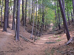
The site of the aqueduct in Newton Cochituate Aqueduct P1160758.jpg
The site of the aqueduct in Newton

The Cochituate Aqueduct was an aqueduct in Massachusetts that brought water to Boston from 1848 to 1951.

Contents

History

The aqueduct formed a key link in Boston's first major water supply system. Its genesis dates to 1845, when a Sudbury River tributary was impounded to form Lake Cochituate in Natick. The artificial lake, with 17 square miles (44 square kilometres) of watershed, 2 billion US gallons (7,600,000 m3) of storage, and yield of 10 million US gallons (38,000 m3) of water per day, became the cornerstone of Boston's public water system.

The aqueduct was built in 1846 to 1848 to convey water from Lake Cochituate to the Brookline Reservoir. Its route was 14 miles (23 km) long and passed through Natick, Wayland, Wellesley, Newton, and Brookline. From there, pipelines ran to small distribution reservoirs throughout Boston, including Beacon Hill Reservoir atop Beacon Hill. In 1848 Lake Cochituate's water first flowed into Frog Pond on Boston Common in a ceremony that drew 100,000 people.

By 1951, four major aqueducts were delivering water to Boston. The Cochituate system was unnecessary with its water declining in quality and requiring treatment. It was thus abandoned, and portions were purchased in 1952 by the City of Newton for sewer lines. It is now part of a trail system, with granite bridges and gatehouses still intact along its route.

In 2010, the Massachusetts Water Resources Authority issued a Use Permit to the Natick Conservation Commission for 16 acres (65,000 m2) of the Natick section for future conservation and recreation purposes.

Route

Portions of the aqueduct route have been overbuilt by roads and other construction, but it is in many areas still discernible.

The Cochituate Aqueduct begins at a gatehouse on the east side of Lake Cochituate, north of Massachusetts Route 30. It passes roughly eastward, eventually running along the town line between Wayland and Natick. It eventually turns southeasterly, skirting around the east side of Morse Pond in Wellesley shortly after passing under Massachusetts Route 9. It again turns east, passing north of Wellesley Town Hall before turning northeasterly through the Hunnewell Field athletic complex and toward Indian Spring Park, where it again turns east. It passes under Walnut and Cedar Streets in eastern Wellesley before descending to cross the Charles River into Newton on a stone bridge. There is a commemorative plaque in a small open park facing Cedar Street. The aqueduct crossing of the river is via an iron siphon tube, whose original control houses on both sides have been demolished. [1]

In Newton, the aqueduct is located in the median dividing the lanes of Waban Avenue, and passes near the Waban MBTA station, before snaking through residential parts of Waban to skirt the southern edge of Cold Spring Park. It proceeds northeasterly to skirt the northern edge of the Newton Centre Playground, where the Sudbury Aqueduct runs along the playground's south side. It then loops northward around Prospect Hill before turning southeast, passing through the Boston College campus, where its route has been obliterated by St. Thomas More Road. It skirts the west side of Chestnut Hill Reservoir (whose construction it predates), before heading mainly southeast, paralleling Reservoir Road, to the western end of the Brookline Reservoir, where its end gatehouse is located. [1]

See also

Related Research Articles

<span class="mw-page-title-main">Newton, Massachusetts</span> City in Massachusetts, United States

Newton is a city in Middlesex County, Massachusetts, United States. It is approximately 7 miles (11 km) west of downtown Boston. Newton resembles a patchwork of thirteen villages, without a city center. According to the 2020 U.S. Census, the population of Newton was 88,923.

<span class="mw-page-title-main">Cochituate, Massachusetts</span> Census-designated place in Massachusetts, United States

Cochituate is a census-designated place (CDP) in the town of Wayland in Middlesex County, Massachusetts, United States. The population was 6,569 at the 2010 census.

<span class="mw-page-title-main">Quabbin Reservoir</span> Massachusetts reservoir which serves the Boston area

The Quabbin Reservoir is the largest inland body of water in Massachusetts, and was built between 1930 and 1939. Along with the Wachusett Reservoir, it is the primary water supply for Boston, 65 miles (105 km) to the east, and 40 other cities and towns in Greater Boston. The Quabbin also supplies water to three towns west of the reservoir and acts as backup supply for three others. By 1989, it supplied water for 2.5 million people, about 40% of the state's population at the time. It has an aggregate capacity of 412 billion US gallons (1,560 GL) and an area of 38.6 square miles (99.9 km2).

<span class="mw-page-title-main">Massachusetts Water Resources Authority</span> Public authority that provides wholesale drinking water and sewage services

The Massachusetts Water Resources Authority (MWRA) is a public authority in the Commonwealth of Massachusetts that provides wholesale drinking water and sewage services to certain municipalities and industrial users in the state, primarily in the Boston area.

<span class="mw-page-title-main">Massachusetts Route 9</span>

Route 9 is a 135.310-mile-long (217.760 km) major east–west state highway in Massachusetts. Along with U.S. Route 20, Route 2, and Interstate 90, Route 9 is one of the major east–west routes of Massachusetts. The western terminus is near the center of the city of Pittsfield. After winding through the small towns along the passes of the Berkshire Mountains, it crosses the college towns of the Pioneer Valley and then south of the Quabbin Reservoir and the rural areas of western Worcester County. Entering the city of Worcester from the southwest corner of the city, it passes through the center of the city and forms the major commercial thoroughfare through the MetroWest suburbs of Boston, parallel to the Massachusetts Turnpike. Crossing the Route 128 freeway circling Boston, it passes through the inner suburbs of Newton and Brookline along Boylston Street, and enters Boston on Huntington Avenue, before reaching its eastern terminus at Copley Square.

<span class="mw-page-title-main">Chestnut Hill, Massachusetts</span> Village in Massachusetts, United States

Chestnut Hill is an affluent New England village located six miles (9.7 km) west of downtown Boston, Massachusetts, United States. Like all Massachusetts villages, Chestnut Hill includes portions of multiple municipalities: Brookline, Newton, and Boston via the neighborhood of Brighton. Chestnut Hill's borders are defined by the 02467 ZIP Code. The name refers to several small hills that overlook the 135-acre Chestnut Hill Reservoir rather than one particular hill. Chestnut Hill is best known as the home of Boston College and as part of the Boston Marathon route.

The Minuteman Library Network (MLN), founded in 1984, is a consortium of 41 public and academic libraries in the MetroWest and southern Middlesex County areas of eastern Massachusetts, US that share resources, patrons and services. The Network has over 6 million items and over 680,000 cardholders. Resources are shared. People who live, work, or study in Massachusetts are eligible for a card, which can be used to borrow items from Minuteman libraries.

<span class="mw-page-title-main">Waban, Massachusetts</span>

Waban is one of the thirteen villages within the city of Newton in Middlesex County, Massachusetts, United States.

<span class="mw-page-title-main">Massachusetts Route 27</span> Highway in Massachusetts, United States

Route 27 is a 73.44-mile-long (118.19 km) south–north state highway in eastern Massachusetts. Its southern terminus is at Route 106 in Kingston and its northern terminus is at Route 4 in Chelmsford. Along the way it intersects several major highways including Route 24 in Brockton, U.S. Route 1 in Walpole, Route 9 in Natick, US 20 in Wayland, and Route 2 in Acton.

<span class="mw-page-title-main">Cochituate State Park</span> State park in Massachusetts, United States

Cochituate State Park is a Massachusetts day-use state park located on Lake Cochituate in the town of Natick. The park is managed by the Department of Conservation and Recreation.

This is a list of historic sites in Framingham, Massachusetts. There are several notable historic sites in Framingham, according to the Framingham Historical Society. This local society asserts:

While there are many historic spaces in Framingham, the Centre Common is the focal point for the town's past. Three of the town's most historic buildings on the Centre Common face "demolition by neglect." The Village Hall, the Edgell Memorial Library, and the Old Academy building not only house over 10,000 artifacts spanning four centuries of the town's history, but they are symbols of Framingham's commitment to educational excellence, civic engagement, and community pride.

Tab Communications Inc., based first in Newton, Massachusetts, United States, then in nearby Needham, was a weekly newspaper publisher in Greater Boston before being bought by Fidelity Investments in 1992 and dissolved into Community Newspaper Company in 1996.

<span class="mw-page-title-main">Old Connecticut Path</span> Native American trail

The Old Connecticut Path was the Native American trail that led westward from the area of Massachusetts Bay to the Connecticut River Valley, the first of the North American trails that led west from the settlements close to the Atlantic seacoast, towards the interior. The earliest colonists of Massachusetts Bay Colony used it, and rendered it wider by driving cattle along it. The old route is still followed, for part of its length, by Massachusetts Route 9 and Massachusetts Route 126.

<span class="mw-page-title-main">Chestnut Hill Reservoir Historic District</span> Historic district in Massachusetts, United States

The Chestnut Hill Reservoir Historic District is a historic district encompassing the Chestnut Hill Reservoir and the surrounding water works facilities which were historically used to provide fresh water to Boston, Massachusetts, and surrounding towns. The district is nearly coextensive with the Chestnut Hill Reservation, a state park managed by the Massachusetts Department of Conservation and Recreation (DCR); those elements of the water works that are still required as an emergency backup are managed by the Massachusetts Water Resources Authority (MWRA). The reservoir is located between Beacon Street and Commonwealth Avenue in Boston's Chestnut Hill district, just east of the Boston College Main Campus Historic District.

<span class="mw-page-title-main">Lake Cochituate</span> Body of water

Lake Cochituate is a body of water in Natick, Wayland, and Framingham, Massachusetts, United States. Originally a reservoir serving Boston, it no longer serves that function, and is now a local recreational resource and home to Cochituate State Park.

<span class="mw-page-title-main">Framingham Reservoir No. 3 Dam and Gatehouse</span> United States historic place

The Framingham Reservoir No. 3 Dam and Gatehouse is a historic waterworks facility in Framingham, Massachusetts. The dam and gatehouse are located at the southeastern end of Framingham Reservoir No. 3, off Massachusetts Route 9. They were built 1876–78 as part of an expansion of the public water supply of the city of Boston. The dam is 2,280 feet (690 m) long, and impounds an area of 253 acres (102 ha) in the Sudbury River watershed. The reservoir is the largest of the three Framingham reservoirs that were built at that time. The dam's core is constructed of granite rubble laid in cement. There is a granite-lined overfall area 100 feet (30 m) long, which was originally topped by flashboards. At the end of the overfall area nearest Route 9 stands the gatehouse, a granite structure with a rectangular main block and a smaller wing. Both sections have a steeply pitched slate roof. The door is in a round-arch recess, and the building is capped by a cupola. It houses controls for two 4-foot (1.2 m) mains connected to the Sudbury Aqueduct via the gatehouse at Reservoir No. 1. The water is directed either directly beyond the dam into reservoir 1 or through the 4-foot mains to the Sudbury Aqueduct gatehouse.

<span class="mw-page-title-main">Sudbury Aqueduct</span> United States historic place

The Sudbury Aqueduct is an aqueduct in Massachusetts. It runs for 16 miles (26 km) from Farm Pond at Waverly Street in Framingham to Chestnut Hill Reservoir in Boston’s Chestnut Hill neighborhood. A later built extension main runs from the Farm Pond gatehouse to the gatehouse at the Stearns Reservoir where additional mains connect to the Brackett and Foss Reservoirs Going east from Framingham, it runs through Sherborn before entering Natick. From Natick it runs east through Wellesley and Needham to the Charles River, which it crosses on the Echo Bridge into Newton. It ends at the Chestnut Hill Reservoir on the Newton side of the Newton-Boston line. The Massachusetts Water Resources Authority (MWRA) operates the aqueduct.

<span class="mw-page-title-main">Fisher Hill Reservoir</span> United States historic place

The Fisher Hill Reservoir and Gatehouse are historic elements of the public water supply for the Greater Boston area.

<span class="mw-page-title-main">Reservoir Park (Massachusetts)</span> United States historic place

Reservoir Park is a historic park on Boylston Street in Brookline, Massachusetts. Its principal feature is Brookline Reservoir, formerly an element of the public water supply for neighboring Boston. The reservoir was built in 1848 as the main terminus of the now-defunct Cochituate Aqueduct, which delivered water from Lake Cochituate in the western suburbs. The reservoir covers 21.1 acres (8.5 ha), and is roughly kidney-shaped. A gravel path extends around the perimeter of the reservoir. The park is bounded on the north by Boylston Street, on the west by Lee Street, on the south by Dudley Street, and on the east by Warren and Walnut Streets.

<span class="mw-page-title-main">Sudbury Reservoir</span>

The Sudbury Reservoir is an emergency backup Boston metropolitan water reservoir in Massachusetts, located predominantly in Southborough and Marlborough, with small sections in Westborough and Framingham. It was created when the Sudbury Dam was constructed to impound the Stony Brook branch of the Sudbury River; no part of the reservoir lies in the town of Sudbury. Nearly 5,000 acres (2,000 ha) in the Sudbury Reservoir watershed are administered by the Massachusetts Department of Conservation and Recreation as a limited-access public recreation area.

References

  1. 1 2 "NHL nomination for Brookline Reservoir" (PDF). National Park Service. Retrieved 2017-01-28.

Coordinates: 42°19′34″N71°12′28″W / 42.3262°N 71.2078°W / 42.3262; -71.2078