The pond is a kettle, a small pond created by glacial melt-water during the last glacial maximum. It is named after John Buckmaster, an early settler who died in 1752 and was the first person to be buried in the Old Westwood Cemetery.[1] The pond appears in historical records as early as 1827, when it was used for baptisms.
In 1885, when Westwood was part of the town of Dedham as the Parish of West Dedham, the water rights of the pond were sold to the neighboring town of Norwood. The anger around selling off of a local water source was a contributing reason for the parish to split from Dedham, which is did when Westwood was incorporated as a town in 1897.[2] Norwood built a pumping station and continued to use the pond as a water source until the late 1970s, when it was discontinued due to unidentified contamination and cheaper water being available from the water district that would become the MWRA.[3]
Westwood is a town in Norfolk County, Massachusetts, United States. The population was 16,057 in 2017.
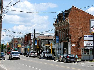
Asphodel–Norwood is a lower tier township municipality in Peterborough County in Central Ontario, Canada, with a 2016 population of 4,109. The land on which the township is situated was the traditional territory of the Mississauga, and became open to European colonization following its survey in 1820. The site that would become Norwood was settled in 1823, and it was incorporated as a village in 1878. The township, in its current form, was created in 1998 by the reunification of the village of Norwood with the surrounding township of Asphodel.
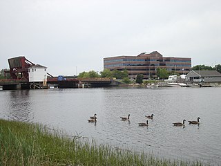
The Neponset River is a river in eastern Massachusetts in the United States. Its headwaters are at the Neponset Reservoir in Foxborough, near Gillette Stadium. From there, the Neponset meanders generally northeast for about 29 miles (47 km) to its mouth at Dorchester Bay between Quincy and the Dorchester section of Boston, near the painted gas tank.
A kettle is a depression/hole in an outwash plain formed by retreating glaciers or draining floodwaters. The kettles are formed as a result of blocks of dead ice left behind by retreating glaciers, which become surrounded by sediment deposited by meltwater streams as there is increased friction. The ice becomes buried in the sediment and when the ice melts, a depression is left called a kettle hole, creating a dimpled appearance on the outwash plain. Lakes often fill these kettles; these are called kettle hole lakes. Another source is the sudden drainage of an ice-dammed lake. When the block melts, the hole it leaves behind is a kettle. As the ice melts, ramparts can form around the edge of the kettle hole. The lakes that fill these holes are seldom more than 10 m (33 ft) deep and eventually become filled with sediment. In acid conditions, a kettle bog may form but in alkaline conditions, it will be kettle peatland.
Massachusetts's 9th congressional district is located in eastern Massachusetts. It is represented by Democrat William R. Keating. The 9th district is the least Democratic Congressional District in Massachusetts according to the PVI.
Mother Brook is a stream that flows from the Charles River in Dedham, Massachusetts, to the Neponset River in the Hyde Park section of Boston, Massachusetts. Mother Brook was also known variously as East Brook and Mill Creek in earlier times. Digging the brook made Boston and some surrounding communities an island, accessible only by crossing over water, making Mother Brook "Massachusetts' Panama Canal."
Massachusetts's 14th congressional district is an obsolete district which was in eastern Massachusetts and the Maine District. It was eliminated in 1963 after the 1960 U.S. Census. Its last Congressman was Joseph William Martin, Jr., who was redistricted into the 10th district.
A flash flood warning is an hazardous weather statement issued by national weather forecasting agencies throughout the world to alert the public that a flash flood is imminent or occurring in the warned area. A flash flood is a sudden, violent flood after a heavy rain, or occasionally after a dam break. Rainfall intensity and duration, topography, soil conditions, and ground cover contribute to flash flooding.
The history of Dedham, Massachusetts, from 1800 to 1899 saw growth and change come to the town. Having been named Dedham shiretown of the newly formed Norfolk County in 1793, the town got an influx of new residents and visitors. This growth was aided by new turnpikes and railroads, with taverns popping up to serve travelers. In the 19th century many former farms would become businesses and homes for those who commuted into Boston. The population of the town more than tripled in this period.
A pond is an area filled with water, either natural or artificial, that is smaller than a lake. Ponds can be created by a wide variety of natural process [e.g. on [floodplain]]s as cut off river channels, by glacial processes, by peatland formation, in coastal dune systems, by beavers) or they can simply be isolated depressions filled by runoff, groundwater, or precipitation, or all three of these. Ponds may be freshwater or brackish in nature. 'Ponds' with saltwater, with a direct connection to the sea that maintains full salinity, would normally be regarded as part of the marine environment because they would not support fresh or brackish water organisms, so not really within the realm of freshwater science.
The Dedham Public School System is a PK–12 graded school district in Dedham, Massachusetts. It is the oldest public school system in the United States.
The history of St. Mary's Church in Dedham, Massachusetts begins with the first mass said in Dedham, Massachusetts in 1843 and runs to the present day.
Dedham Savings is one of the oldest American banks still in operation and one of the oldest banks in the state of Massachusetts still doing business under its original charter.
The Tri-Valley League or TVL is a high school athletic league located in towns in Middlesex and Norfolk counties, Massachusetts. The league was founded in 1966 by principals and Alfred “Hap’’ Mazukina, who served as the league's commissioner for 23 years. In its infancy the TVL struggled but over the years has undergone changes and is now regarded more than 50 years later as one of the most respected high school sports leagues in Massachusetts.
The history of Dedham, Massachusetts from 1700 to 1799 saw the town become one of the largest and most influential country towns in Massachusetts. As the population grew and residents moved to outlying areas of the town, battles for political power took place. Similar battles were taking place within the churches, as liberal and conservative factions bristled at paying for ministers with whom they had differences of theological opinion. New parishes and preciencts were formed, and eventually several new towns broke away.
Massachusetts House of Representatives' 11th Norfolk district in the United States is one of 160 legislative districts included in the lower house of the Massachusetts General Court. It covers part of Norfolk County. Democrat Paul McMurtry of Dedham has represented the district since 2007.
Nathaniel Whiting was an early settler of Dedham, Massachusetts. He owned several mills on Mother Brook and is said to have dug the canal, the first man-made water way in America.
Ezra Morse (1643-1697) was an early resident of Dedham, Massachusetts and owned the second mill on Mother Brook.
This is a timeline of the history of the town of Dedham, Massachusetts.
Rev. Jabez Chickering was the minister of what is today First Congregational Church Norwood from July 3, 1776, to March 12, 1812.
This page is based on this Wikipedia article Text is available under the CC BY-SA 4.0 license; additional terms may apply. Images, videos and audio are available under their respective licenses.