The Taunton River, is a river in southeastern Massachusetts in the United States. It arises from the confluence of the Town River and Matfield River, in the town of Bridgewater. From there it meanders through the towns of Halifax, Middleborough and Raynham, through the city of Taunton for which it is named, the towns of Berkley, Dighton, Somerset, and the Assonet section of Freetown, to Fall River where it joins Mount Hope Bay, an arm of Narragansett Bay.

The Assonet River is located in Bristol County, Massachusetts. It flows 7.4 miles (11.9 km) in a westerly direction through Freetown and joins the Taunton River near Assonet Neck in Berkley, Massachusetts.

The Westport River lies between Narragansett Bay and Buzzards Bay in Westport, Massachusetts.
Conspiracy Island is a privately owned tidal island situated in the Assonet River off Berkley, Massachusetts.

The Bungay River is a short river in southeastern Massachusetts that is a tributary of the Ten Mile River.

The Canoe River is a river in southeastern Massachusetts. It is 14.4 miles (23.2 km) long and part of the Taunton River Watershed.
West Omaha is a geographic area of Omaha, Nebraska that comprises all points within the Omaha metropolitan area west of 72nd Street.

The Quinsigamond River is a river in central Massachusetts. It is a tributary of the Blackstone River and ultimately drains into Narragansett Bay.

Mount Hope Bay is a tidal estuary located at the mouth of the Taunton River on the Massachusetts and Rhode Island border. It is an arm of Narragansett Bay. The bay is named after Mount Hope, a small hill located on its western shore in what is now Bristol, Rhode Island. It flows into the East Passage of Narragansett Bay and also the Sakonnet River. Mount Hope Bay has played an important role to the history of the area, from pre-colonial times to the present. While many years of sewage and industrial pollution have severely degraded the quality of the shallow waters of the bay, there are currently major efforts underway to clean up and restore it.
Bay du Nord Wilderness Reserve is located in central part of the Island of Newfoundland in the province of Newfoundland and Labrador, Canada. The area encompasses an area of 2,895 km2 and is considered one of the last remaining unspoiled areas of the province devoid of human habitat. It was officially created as a wilderness reserve in 1990.
The Rocky River is a 50.3-mile-long (81.0 km) tributary of the Savannah River in the U.S. state of South Carolina. It flows into the Savannah River just west of Calhoun Falls at 34°05′28″N82°38′25″W. It forms as the confluence of Beaverdam Creek and Little Beaverdam Creek northeast of Anderson at 34°34′13″N82°33′02″W.
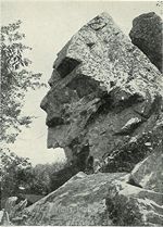
Profile Rock is a 50-foot high granite rock formation located in Freetown, Massachusetts just outside Assonet village and near the Freetown State Forest. Local Wampanoags believe it to be the image of Chief Massasoit. The Wampanoags occupied the region of Rhode Island and Massachusetts bounded by Narragansett Bay to the west and the Atlantic Ocean to the east, and Chief Massasoit was a close friend to the early Pilgrim settlers.

Myricks is an association community or populated place located in Berkley, Bristol County, Massachusetts at latitude 41.831 and longitude -71.027. The elevation is 62 feet. Myricks appears on the Assonet U.S. Geological Survey Map.
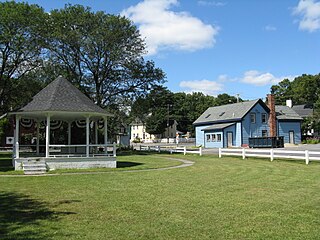
The Assonet Burying Ground is the main public cemetery for Freetown, Massachusetts.

Franklin Manor-on-the-Bay is an unincorporated community or populated place located in Anne Arundel County, Maryland at latitude 38.802 and longitude -76.515. The elevation is 3 feet. Franklin Manor-on-the-Bay appears on the Deale U.S. Geological Survey Map. Anne Arundel County is in the Eastern time zone (UTC-5).
Mill Run is a 9.1-mile-long (14.6 km) tributary stream of the South Branch Potomac River, belonging to the Potomac River and Chesapeake Bay watersheds. The stream is located in Hampshire County in the Eastern Panhandle of the U.S. state of West Virginia. Mill Run rises on Nathaniel Mountain and flows northeast, then northwest into the South Branch south of Romney near Hampshire Park on South Branch River Road.

Strinestown is an unincorporated community in Conewago Township, York County, Pennsylvania, United States.
The Cedar Swamp River is a small river in Lakeville, Massachusetts that flows 4.6 miles (7.4 km) in a northwesterly direction through the western part of the town to where it forms the Assonet River near the Freetown line, just south of the village of Myricks. It is a tributary of the Taunton River.
Agardhelva is a river forming the border between Sabine Land and Heer Land at Spitsbergen, Svalbard. It flows through the valley of Agardhdalen, from the glaciers Elfenbeinbreen and Sveigbreen, ending into the bay Agardhbukta at the western side of Storfjorden. The river is named after botanist Jacob Georg Agardh.
Lynn is an unincorporated community in Morrill County, Nebraska, in the United States.