
Oxford is a census-designated place (CDP) in the town of Oxford in Worcester County, Massachusetts, United States. The population was 6,103 at the 2010 census.
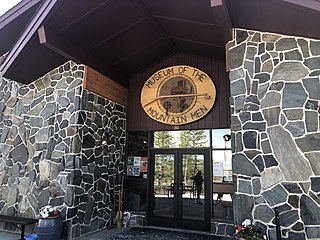
Museum of the Mountain Man is a museum located in Pinedale, Wyoming, US that exhibits western historical pieces relating to the mountain men who explored the region in the early to middle part of the 19th century. The museum is typically open during the summer months.
The Salem Channel is a channel in the Salem Sound that stretches from Winter Island in the city of Salem to Misery Shoal in the city limits of Beverly.
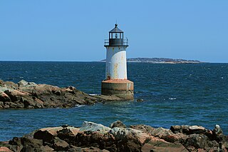
Winter Island is an island connected by a causeway to Salem Neck in Salem, Massachusetts. It is about 45 acres (18 ha) in size, and is bounded by Smith Pool to the northwest, Cat Cove to the west, Salem Channel to the south and east, and Juniper Cove to the north. The island has about a dozen residences at the north end and one road, Winter Island Road. The Plummer Home for Boys sits on 18 acres (7.3 ha) of land on the northeastern shore. The balance of the island is Winter Island Marine Park. The entire island was added to the National Register of Historic Places as Winter Island Historic District and Archeological District in 1994.
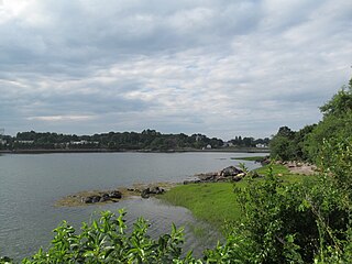
Cat Cove is a cove in the northwestern portion of Salem Harbor in Salem, Massachusetts. The cove is located between Winter Island and Salem Neck. There is a powerplant located on the coast of Salem Neck bordering the southwestern edge of Cat Cove.

Salem Neck is a peninsula in northeastern Salem, Massachusetts, in the United States. It stretches from Salem's powerplant on Salem Harbor to Juniper Point on Salem Neck. The peninsula is populated primarily by residential and recreational areas. Winter Island is an island connected to its mid-western coast by a causeway.

Langlee Island or Langley Island is an island in the Hingham Bay area of the Boston Harbor Islands National Recreation Area. The island has a permanent size of 4 acres (16,000 m2), plus an intertidal zone of a further 3 acres (12,000 m2), and is composed of a massing of Roxbury puddingstone which rises to a height of 40 feet (12 m) above sea level. This results in steep cliffs on the northern shore, while there are several small sandy beaches and a tidal mudflat on the east side. The center of the island contains glacial till that supports tree and shrub cover. As a result of previous planting, the island hosts large examples of oak, maple, juniper, and birch trees, while self-seeded huckleberry and viburnum mix with common greenbriar, dewberry, sumac, and poison ivy.

Crowninshield Island, also known as Brown's Island, is a small island off the shore of Marblehead, Massachusetts. Since 1955, it has been maintained by The Trustees of Reservations. For all Trustees of Reservations purposes, the island is referred to as Crowninshield Island, however federally the island is still maintained as "Brown's Island", and it remains better known by that name locally.

Fort Lee is a historic American Revolutionary War fort in Salem, Massachusetts. The site, located at a high point next to Fort Avenue on Salem Neck, is a relatively rare fortification from that period whose remains are relatively unaltered. It is an irregular 5-pointed star fort. Although there is some documentary evidence that the Neck was fortified as early as the 17th century, the earthworks built in 1776 are the first clear evidence of the site's military use. Reportedly, the fort had a garrison of 3 officers and 100 artillerymen with 16 guns. The site, of which only overgrown earthworks and a stone magazine survive, was repaired in the 1790s, and rebuilt for the American Civil War. A state cultural resource document states that the fort has not been much modified since the Revolution, and has not been built over. It was garrisoned by the Massachusetts militia in the War of 1812, abandoned afterwards, and rebuilt with four 8-inch columbiads in the Civil War. An Army engineer drawing dated 1872 depicts the fort's five-pointed trace and the four Civil War gun positions. It was also garrisoned during the Spanish–American War.

The Misery Islands are an 87-acre (350,000 m2) nature reserve established in 1935 in Salem Sound close to the Salem Harbor in Salem, Massachusetts. It is managed by the Trustees of Reservations. The islands are a part of the city of Salem, although they are much closer to the mainland of the city of Beverly, in whose aquatic territory they lie.
Essex Probate and Family Court is a Court Located on 36 Federal Street in Salem, Massachusetts in the County of Essex. The court deals in Probate and Family Law matters.

The Salem Athenaeum, founded in 1810, is one of the oldest membership libraries in the United States. The Athenaeum is located at 337 Essex Street in Salem, Massachusetts in the McIntire Historic District.
Lower Lance Cove is a local service district and designated place in the Canadian province of Newfoundland and Labrador.

Old Burial Hill is a historic cemetery in Marblehead, Massachusetts. It is located on the high ground between Marblehead's colonial-era residential and retail district, called "Downtown" by longtime residents and "Old Town" by others, and the Barnegat neighborhood that stretches from Little Harbor to Doliber's Cove, and is accessible via a walkway at Redd's Pond and a stairway at the intersection of Orne and Pond streets. It was the location of Marblehead's First Meeting House built around 1638. Old Burial Hill features scenic vistas of Marblehead Harbor and Salem Sound.
Dubnica is a village in the municipality of Vranje, Serbia. According to the 2002 census, the village has a population of 819 people.
The 1984 U.S. Women's Open was the 39th U.S. Women's Open, held July 12–15 at Salem Country Club in Peabody, Massachusetts. Hollis Stacy won her third U.S. Women's Open, one stroke ahead of runner-up Rosie Jones. It was Stacy's fourth and final major title.
Fort Juniper was a fort that existed from 1775 in Salem, Massachusetts during the American Revolutionary War. It was also known as Fort Number One during its existence.
Coney Island is an abandoned island located in Massachusetts Bay in Salem, Massachusetts. It has light growth, with a small salt marsh.
Gypsum Wash is an ephemeral stream or wash in Clark County, Nevada. Gypsum Wash was originally a tributary of Las Vegas Wash before the formation of Lake Mead which submerged their confluence under Las Vegas Bay. Due to the lowering of the reservoir over recent years Gypsum Wash is once again a tributary of Las Vegas Wash, now exposed at 36°07′04″N114°50′54″W at an elevation of 1085 feet. When Las Vegas Bay is at its full level, Gypsum Wash flows into Lower Gypsum Wash Cove at 36°07′43″N114°51′26″W at an elevation of 1,204 feet.
