
Clifton was a street car stop within the towns of Swampscott and Marblehead in Essex County, Massachusetts, United States. It includes Clifton Avenue.
Winter Island is an island connected by a causeway to Salem Neck in Salem, Massachusetts. It is about 45 acres (18 ha) in size, and is bounded by Smith Pool to the northwest, Cat Cove to the west, Salem Channel to the south and east, and Juniper Cove to the north. The island has about a dozen residences at the north end and one road, Winter Island Road. The Plummer Home for Boys sits on 18 acres (7.3 ha) of land on the northeastern shore. The balance of the island is Winter Island Marine Park. The entire island was added to the National Register of Historic Places as Winter Island Historic District and Archeological District in 1994.

Smith Pool is a small body of water located between Salem Neck, Winter Island, and Cat Cove in Salem, Massachusetts, United States. It used to be the city's reservoir, and was later a public swimming area. It is easily accessible from Winter Island Road on Winter Island. The area is currently maintained by the Massachusetts Division of Marine Fisheries, and the old dam still separates it from Cat Cove. The dam has a tide gate to allow circulation between Cat Cove and Smith Pool and to allow manipulation of the water depth in Smith Pool. The intake pipes for the Cat Cove Marine Lab seawater system are in Smith Pool

Salem Harbor is a harbor in northeastern Massachusetts spanning an area north and south of Salem. Historically the Salem Harbor was the site of one of the major international ports in the colonies. During the American Revolutionary War, merchant ships were enlisted as privateers, an important role to augment the ill-prepared Continental Navy. In 1790, Salem Harbor was a world-famous seaport and sixth-largest in the United States of America. Now the harbor is used for commercial and recreational purposes and the Salem Maritime National Historic Site is very popular with tourists from around the world.

Juniper Cove is a cove in the Salem Channel, within the city limits of Salem, Massachusetts, USA. The Salem Neck coast that borders Juniper Cove is mostly residential areas.

Salem Neck is a peninsula in northeastern Salem, Massachusetts, in the United States. It stretches from Salem's powerplant on Salem Harbor to Juniper Point on Salem Neck. The peninsula is populated primarily by residential and recreational areas. Winter Island is an island connected to its mid-western coast by a causeway.

Bakers Island is a small, private residential island in Massachusetts Bay, in Salem, Massachusetts. It is located southeast of Great Misery Island & Little Misery Island, northeast of North Gooseberry Island and South Gooseberry Island, and far northeast of Children's Island. It is the outermost island on the main shipping channel into Salem Harbor. Bakers Island Light, located on the island's northern side, is used for navigation.
Bassetts Island is a Y-shaped island within Pocasset Harbor and Red Brook Harbor, in Bourne, Massachusetts, USA. 41-40’48” North x 070-38’13” West

Houghs Neck is a one-square-mile (2.6 km2) peninsula in Quincy, Massachusetts. It is surrounded by Quincy Bay, Hingham Bay and Rock Island Cove. It is lined by Perry Beach, which runs along Manet Avenue; Nut Island, which is just beyond Great Hill at the very end of the peninsula; and Edgewater Drive.

Crowninshield Island, also known as Brown's Island, is a small island off the shore of Marblehead, Massachusetts. Since 1955, it has been maintained by The Trustees of Reservations. For all Trustees of Reservations purposes, the island is referred to as Crowninshield Island, however federally the island is still maintained as "Brown's Island", and it remains better known by that name locally.

Plymouth Bay is a small, well-protected bay of the Atlantic Ocean on the western shore of larger Cape Cod Bay along the coastline of the Commonwealth of Massachusetts. Plymouth Bay retains historical significance for the landing at Plymouth Rock in 1620 by the Pilgrims aboard the Mayflower who proceeded to establish the first permanent Northern European settlement in North America at Plymouth Colony.

Clark's Island is the name of a small island located in Duxbury Bay in the U.S. state of Massachusetts. It was named for John Clark, the first mate of the Mayflower, the ship that brought the Pilgrims to New England. The island was initially considered for the location of the Pilgrim's settlement, but was rejected in favor of a site to the south, which became known as Plymouth, Massachusetts. Today Clark's Island is a part of the town of Plymouth.

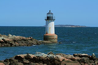
Fort Lee is a historic American Revolutionary War fort in Salem, Massachusetts. The site, located at a high point next to Fort Avenue on Salem Neck, is a relatively rare fortification from that period whose remains are relatively unaltered. It is an irregular 5-pointed star fort. Although there is some documentary evidence that the Neck was fortified as early as the 17th century, the earthworks built in 1776 are the first clear evidence of the site's military use. Reportedly, the fort had a garrison of 3 officers and 100 artillerymen with 16 guns. The site, of which only overgrown earthworks and a stone magazine survive, was repaired in the 1790s, and rebuilt for the American Civil War. A state cultural resource document states that the fort has not been much modified since the Revolution, and has not been built over. It was garrisoned by the Massachusetts militia in the War of 1812, abandoned afterwards, and rebuilt with four 8-inch columbiads in the Civil War. An Army engineer drawing dated 1872 depicts the fort's five-pointed trace and the four Civil War gun positions. It was also garrisoned during the Spanish–American War.

The Misery Islands are an 87-acre (350,000 m2) nature reserve established in 1935 in Salem Sound close to the Salem Harbor in Salem, Massachusetts. It is managed by the Trustees of Reservations. The islands are a part of the city of Salem, although they are much closer to the mainland of the city of Beverly, in whose aquatic territory they lie.
Essex Probate and Family Court is a Court Located on 36 Federal Street in Salem, Massachusetts in the County of Essex. The court deals in Probate and Family Law matters.

Children's Island, formerly known as "Cat Island" is an island off Marblehead, Massachusetts, and is part of the City of Salem, Massachusetts. The YMCA of the North Shore has owned and operated a children's day camp on it since 1955. The first written record of the island was in 1655 when it was granted to Governor John Endecott. It was then bought and sold several times until around the Revolutionary War when the Essex hospital was built as a smallpox inoculation site. The hospital was burned down by townspeople of Marblehead. By the end of the 19th century, the Lowell island house was established as a summer resort. This was run for about 30 years before being converted into a sanitarium for sick and crippled children until 1946. The island then lay unused until bought by the YMCA and converted into a day camp.

Old Burial Hill is a historic cemetery in Marblehead, Massachusetts. It is located on the high ground between Marblehead's colonial-era residential and retail district, called "Downtown" by longtime residents and "Old Town" by others, and the Barnegat neighborhood that stretches from Little Harbor to Doliber's Cove, and is accessible via a walkway at Redd's Pond and a stairway at the intersection of Orne and Pond streets. It was the location of Marblehead's First Meeting House built around 1638. Old Burial Hill features scenic vistas of Marblehead Harbor and Salem Sound.

Cormorant Rock is a small island about 300 feet off the southeastern tip of Children's Island just outside Marblehead Harbor, at latitude 42.510ºN, longitude 70.812ºW. Formerly known as Cat Island Rock and Eastern Rock of Cat Island, it is considered to be a part of Children's Island and was the location of a navigational spar erected in 1808 by the Marblehead Marine Society. Both islands are part of the city of Salem, even though they are closer to mainland Marblehead and are enclaved by its (water) territory.
Camp Hill was an encampment site of the Provisional Army of the United States that existed from 1799 to 1800 in Oxford, Massachusetts. A marker placed by the General Ebenezer Learned chapter of the Daughters of the American Revolution commemorates the encampment of Colonel Nathan Rice's regiment in those years. The camp was visited by Alexander Hamilton as the Senior Officer of the United States Army in 1800.
Coney Island is an abandoned island located in Massachusetts Bay in Salem, Massachusetts. It has light growth, with a small salt marsh.
