Green Pond is a private lakeside residential unincorporated community within Rockaway Township in Morris County, New Jersey, United States. The lakeside community is managed by two corporations, Green Pond Corporation and Lake End Corporation.

Lake Attitash is a lake located on the border of Merrimac, Massachusetts and Amesbury, Massachusetts, and constitutes at least a portion of Amesbury's water supply.

Long Pond is a 1,721-acre (7.0 km2) lake within the towns of Lakeville and Freetown, in southeastern Massachusetts. It shares its waters with Assawompset Pond. These lakes provide a source of drinking water to the city of New Bedford, the largest city in southeastern Massachusetts. Long Pond is roughly one mile (1.6 km) wide by four miles (6.4 km) miles long, and contains three islands within its boundaries. In 1894 Assawompset Pond was dammed, increasing the water depth of Long Pond by about five feet (1.5 m). This created Nelson Island and caused Sunken Island to disappear due to erosion. All that remains of Sunken Island are the rocks in a shallow area just to the northwest of Lewis Island. Lewis Island is the largest of the three remaining islands today, containing sixteen privately owned cottages, while the second largest island, Nelson Island, was purchased in 2005 and now is a year-round private residence. The smallest island, Goat Island, was recently purchased from the Boy Scouts by a private citizen. Along the perimeter of the lake are many homes and private access points to the waterfront. Long Pond is well known for fishing and boating.

Dug Pond is a small body of water in Natick, Massachusetts. Most notably it is home to Memorial Beach, one of few swimming beaches in Natick, and its eastern shore is the site of Natick High School.

Halfway Pond a 232-acre (0.94 km2) warm water pond located in Plymouth, Massachusetts between Myles Standish State Forest and Long Pond, west of Round Pond, southwest of Gallows Pond, and north of Fawn Pond and White Island Pond. The average depth is nine feet and the maximum depth is 13 feet (4.0 m). The pond is fed by groundwater springs and drains into the Agawam River. Halfway Pond Island lies in the middle of the pond and is managed as a research natural area by The Nature Conservancy in Massachusetts. There are almost three miles (5 km) of shoreline.

Monponsett Pond, also called Monponsett Lake and the Twin Lakes, originally one lake is dissected by route 58 into a system of two ponds, West and East, mostly in Halifax, Massachusetts, with a small portion of West Monponsett Pond extending into Hanson. The western basin is 308 acres (1.25 km2), and the eastern basin is 272 acres (1.10 km2). The average depth of both ponds is seven feet and the maximum depth is 13 feet (4.0 m). The outflow is Stump Brook, located in the northwestern part of West Monponsett Pond, which flows in a southwest direction into Robbins Pond, which forms the headwaters of the Sautucket River, a tributary of The Taunton River. The pond is part of the Taunton River Watershed. Water from Monponsett is diverted into Silver Lake, the principal water supply for the City of Brockton. Water diversions from Monponsett into Silver lake are not permitted during the summer months from June 1 - September 30. Diversions are only allowed during the months of October through May.
Curlew Pond is a 43-acre (170,000 m2) natural warm water pond in Plymouth, Massachusetts, located in the Myles Standish State Forest.

Robbins Pond is a 124-acre (0.50 km2) warm water pond in East Bridgewater and Halifax, Massachusetts. It is part of the Taunton River Watershed. The inflow is Poor Meadow Brook, and the outflow is the Satucket River.The water is brown in color with a transparency of five feet, and the bottom is a mixture of sand and gravel. Average depth is four feet and maximum depth is just ten feet. There are 1.7 miles (2.7 km) of shoreline.
Bloody Pond is a 98-acre (400,000 m2) natural kettlehole pond in Plymouth, Massachusetts, near Long Pond village. The pond is located southeast of Long Pond. This pond, visible from the southbound side of Route 3 past the Ship Pond Road bridge, is fed by groundwater and has over two miles (3 km) of shoreline. The average depth is 17 feet (5.2 m) and the maximum depth is 38 feet (12 m). Legal public access to the pond is obtained through a dirt road off of Long Pond Road and is suitable primarily for shore and wading fishermen as the access point is a long walk from a two-car parking lot in front of a gate.

Little Herring Pond is a 90-acre (360,000 m2), shallow natural pond in the Cedarville section of Plymouth, Massachusetts, USA. The pond is located north of Great Herring Pond, west of Hedges Pond, southwest of Black Jimmy Pond, northeast of Island Pond and Triangle Pond, and east of Long Duck Pond. The pond has an average depth of three feet and a maximum depth of only four feet. The outflow is a stream that feeds Great Herring Pond, which in turn feeds the Herring River. Access to the pond is via a dirt road off Carters Bridge Road.
Fearing Pond, also erroneously named on some maps as Fearings Pond, is a 24-acre (97,000 m2) natural kettlehole pond in Plymouth, Massachusetts. The average depth is ten feet and the maximum depth is 20 feet (6.1 m). It is located in the southern section of Myles Standish State Forest, north of Charge Pond, northwest of Abner Pond, west of Fawn Pond, south of College Pond, southeast of East Head Reservoir, and east of the forest headquarters. However there is no direct access as the bridge over the Wankinco River connecting Cranberry Road in Carver and Fearing Pond Road in Plymouth was washed out several years ago. The bridge has not been rebuilt.
Barrett Pond is a 16-acre (65,000 m2), warm water pond in the Myles Standish State Forest in Carver, Massachusetts, located less than ½ mile north of the forest headquarters, west of East Head Reservoir, and southwest of College Pond in Plymouth. The pond has an average depth of six feet and a maximum depth of 17 feet (5.2 m). Most of the shoreline is undeveloped except for a campground area on the eastern shore. Access is possible off Lower College Pond Road and is suitable only for car top boats or canoes, electric motors only.

Glen Charlie Pond is a 185-acre (0.75 km2) warm water pond in Wareham, Massachusetts. The maximum depth of the pond is 12 feet (3.7 m). The pond is part of the Agawam River. The pond is located southwest of White Island Shores, northeast of Spectacle Pond, north of Sandy Pond, and approximately 2 miles (3.2 km) north of Route 25. Exit 2 off Route 25 eastbound provides direct access along Glen Charlie Road. The pond is developed with summer and year-round homes mostly along the southern and eastern shores. Public access is possible through town-owned land at the gas pipeline crossing. This pond is popular for both warm-water fishing and ice fishing.
Indian Pond is a 66-acre (270,000 m2) shallow, infertile, warm-water pond in Kingston and Plympton, Massachusetts, west of Route 80 and north of the new U.S. Route 44 highway. The average depth of the pond is three feet. Access to the pond is off Indian Road in Plympton. Fishing is regarded as generally poor due to the acidity of the water and the pond's natural infertility.

Tispaquin Pond is a 194-acre (0.79 km2) warm water pond in Middleborough, Massachusetts. The pond is in the Taunton River Watershed. The average depth of the pond is seven feet, and the maximum depth is eight feet. Transparency of the water is six feet. Shorts Brook and Woods Brook provide the inflow for the pond. The outflow is Fall Brook, a tributary of the Nemasket River. Camp Avoda and Camp Yomechas are located on the pond. Access to the southern shore of the pond is via Eldon Street off Rocky Gutter Street. An unpaved launch area is suitable for car top boats and canoes. It is a popular spot for recreational fishing, particularly for yellow perch and largemouth bass.
Stetson Pond is a 93-acre (380,000 m2) warm water pond in Pembroke, Massachusetts. The average depth is 15 feet (4.6 m) and the maximum depth is 33 feet (10 m). The pond is characterized by brown water with a transparency of five feet. Access to the pond is provided by a dirt launch located off Plymouth Street, near Route 36. The launch is suitable for car top boats and canoes and is owned by the Town of Pembroke.

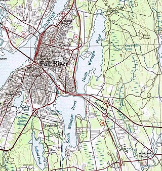
The Watuppa Ponds are two large, naturally occurring, spring-fed, glacially formed ponds located in Fall River and Westport, Massachusetts. Watuppa is a native word meaning "place of boats". The two ponds were originally one body of water, connected by a narrow rocky straight called "The Narrows" located on a thin strip of land between the two ponds which forms part boundary of between Fall River and Westport. The border between Fall River and Westport is also divided between the two ponds. Together, the ponds have an overall north–south length of about 7.5 miles, and have an average east–west width of about a mile. The ponds are drained by the Quequechan River, and flows in a westerly direction through the center of Fall River from South Watuppa Pond to Mount Hope Bay.

Lake Rescue is located in Windsor County of south central Vermont, in the northeastern United States. Occupying 180 acres (73 ha) and reaching depths of 95 feet (29 m), it is the tenth-deepest and 23rd-largest lake in the state. Lake Rescue is located along VT Route 100 about three miles north of Ludlow and Okemo Mountain, and it is surrounded by the town of Ludlow. The lake is fed by the Black River and is the third of four lakes extending from Plymouth, Vermont through Ludlow, with Lake Amherst and Echo Lake to the north and Lake Pauline to the south. The northern section of the lake, connected to the main body via a shallow channel, is referred to as Round Pond.

Enchanted Pond is a mountain pond in the U.S. state of Maine. Situated in the Western Maine Mountains in the Northwest Somerset Region, the pond is located in a deep mountain valley between Coburn Mountain and Shutdown Mountain. Near its southern end, the pond is distinguished by two rockslides from the exposed cliffs of these mountains that extend down into the water along both shores. Enchanted Pond is fed by mountain springs and Little Enchanted Pond, and is the primary source of Enchanted Stream which flows into the Dead River, a tributary of the Kennebec River. Development on the pond is limited to a small set of sporting camps at the northern end of the pond and one remote camp on the southwest shore, both a part of Bulldog Camps. There are no islands in the pond.

New Rochelle Harbor is the name of a harbor located along Long Island Sound in the city of New Rochelle in Westchester County, New York. The Davenport Neck peninsula off the mainland divides New Rochelle's waterfront into two bays; the westerly referred to as New Rochelle Harbor and the easterly as Echo Bay.


