Menemsha Pond

Last updated
Menemsha Pond
Relief map of USA Massachusetts.png
Red pog.svg
Menemsha Pond
Location Chilmark, Massachusetts & Aquinnah, Massachusetts
Coordinates 41°20′20″N70°46′25″W / 41.33889°N 70.77361°W / 41.33889; -70.77361 Coordinates: 41°20′20″N70°46′25″W / 41.33889°N 70.77361°W / 41.33889; -70.77361
Type Salt Pond
Basin  countriesUnited States
Surface area665 acres (269 ha)

Menemsha Pond is a salt pond split between the towns of Aquinnah & Chilmark, Massachusetts. [1] At the mouth of the pond, the Menemsha Creek leads into the Menemsha Bight and the Vineyard Sound. Along Menemsha Creek sits the historic sea-side fishing village of Menemsha. Menemsha Pond connects to both Stonewall Pond via Nashaquitsa Pond and to Squibnocket Pond via the Squibnocket Herring Run.

Contents

Since 1902, Menemsha Pond is a federally recognized Harbor of Refuge. [2] This designation altered the development of both the harbor at Menemsha and the channel into Menemsha Pond. Before the federal designation and redesign of the inlet, the channel was dredged locally to maintain access.

History

Archeological exploration indicates that indigenous peoples of the Wampanoag tribe have inhabited the shores of Menemsha Pond for approximately 10,000 to 7,500 years. [3] Additionally, the tribe still maintains a presence on the pound with the tribal run hatchery, herring run, and with the tribal members who fish both recreationally and commercially. [4] In his 1969 book, Archaeology of Martha's Vineyard, William A Ritchie excavated and carbon-dated materials found in the shell middens and living sites around the Vineyard including around Menemsha and Sqiudnocket Pond. [5]

In 1748 the Menemsha Road was laid out from Menemsha Pond to the common (south) road.

In 1890, the Chief of Engineers of the US Army conducted a preliminary examination of Menemsha Bight

Menemsha Bight, Massachusetts, an outlet into Vineyard Sound, on the north shore of the island of Marthas Vineyard, with a view of preventing the closing of said inlet. The improvement desired at this locality is the formation of a harbor of refuge for light-draft vessels by the construction of jetties and shore protection, estimated to cost $25,000. While this locality is regarded by Major Livermore and Col. Abbot as worthy of improvement, it is the opinion of these officers that in view of the difficulty of maintaining the improvement and of its large cost the demands of commerce do not justify the work being undertaken at the present time. Menemsha Bight is in the collection district of Edgartown, which is a port of entry. The amount of revenue collected at Edgartown in the last fiscal year was $310.94. [6]

Although no work was done on the bight or creek at that time, this report would be a harbinger.

In 1938, all but one building in the town of Menemsha was destroyed during the hurricane of 1938. The strong surf surged through Menemsha and the small barrier beach that separated Menemsha pond and the ocean, washing away the collection of fishing shacks that populated the village. In the aftermath of the hurricane, the Army Corps of Engineers dredged the channel and built jetties on either side, hardening Menemsha's status as a port of refuge. The Menemsha channel would wander and change shape often, until the jetties were built. In fact, the Wampanoag word for the channel to Menemsha Pond is Wawitukq, meaning "the winding, twisting river". [7] The 1938 hurricane also greatly damaged the fishing villages of Lobsterville and Squibnocket, both of whom would never recover. The new dredging of Menemsha harbor, with its added depth and dock space, made it ideal for the newly innovated motor-powered fishing and leisure boats.

Menemsha Bike Ferry

The Menemsha Bike Ferry, also known as the Aquinnah-Menemsha ferry, travels the short distance between Aquinnah and Chilmark, taking bikes and pedestrians over the water where Menemsha Pond meets Menemsha Creek. [8]

Bike Ferry, Menemsha MA Bike Ferry, Menemsha MA.jpg
Bike Ferry, Menemsha MA
Menemsha Pond connects to the Vineyard Sound via the Menemsha Creek, ~1935 Menemsha Creek, Mass (68478).jpg
Menemsha Pond connects to the Vineyard Sound via the Menemsha Creek, ~1935

Administration

The pond is dually administered by the towns of Aquinnah and Chilmark. Each town has their own harbormaster. [9]

Aquinnah HarbormasterChilmark Harbormaster
Chip Vanderhoop Ryan Rossi

Fishing & Aquaculture

Menemsha Pond supports commercial oyster farming. The towns also seed bay scallops, quahogs, and oysters in the pond. In addition, the Wampanoag Tribe of Gay Head runs a hatchery on the southwest side of the pond. In the past, the hatchery conducted flounder spawning programs. Currently, there are no spawning programs; however, the tribe monitors the adjacent herring run from the hatchery building. [10]

Shellfish in Menemsha Pond, 1911 FMIB 42973 Mussel bed at Menemsha Pond, Marthas Vineyard, Massachusetts, exposed at low tide.jpeg
Shellfish in Menemsha Pond, 1911
Aquinnah Shellfish ConstableChilmark Shellfish Constable
Buddy Vanderhoop Isaiah Scheffer
Natural Resource Department of the Wampanoag Tribe of Gay Head
Bret Stearns, Director - - - - - - - - - - - 508-645-9265 ext. 141

Related Research Articles

Marthas Vineyard Island south of Cape Cod, Massachusetts, U.S.

Martha's Vineyard is an island located south of Cape Cod in Massachusetts in the United States in North America that is known for being a popular summer colony. Martha's Vineyard includes the smaller adjacent Chappaquiddick Island, which is usually connected to the Vineyard. The two islands have sometimes been separated by storms and hurricanes, which last occurred from 2007 to 2015. It is the 58th largest island in the United States, with a land area of about 96 square miles (250 km2), and the third-largest on the East Coast of the United States, after Long Island and Mount Desert Island. Martha's Vineyard constitutes the bulk of Dukes County, Massachusetts, which also includes the Elizabeth Islands and the island of Nomans Land.

Aquinnah, Massachusetts Town in Massachusetts, United States

Aquinnah is a town located on the western-end of Martha's Vineyard island, Massachusetts. From 1870 to 1997, the town was incorporated as Gay Head. At the 2020 U.S. census, the population was 439. Aquinnah is known for its beautiful clay cliffs and natural serenity, as well as its historical importance to the native Wampanoag people. In 1965, Gay Head Cliffs were designated as a National Natural Landmark by the National Park Service.

Chilmark, Massachusetts Town in Massachusetts, United States

Chilmark is a town located on Martha's Vineyard in Dukes County, Massachusetts, United States. The population was 1,212 at the 2020 census. The fishing village of Menemsha is located on the western side of the town along its border with the town of Aquinnah. Chilmark had the highest median home sale price of any town or city in Massachusetts in 2013.
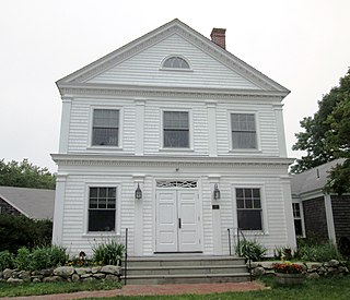
Edgartown, Massachusetts Town in Massachusetts, United States

Edgartown is a tourist destination on the island of Martha's Vineyard in Dukes County, Massachusetts, United States, for which it is the county seat.

Oak Bluffs, Massachusetts Town in Massachusetts, United States

Oak Bluffs is a town located on the island of Martha's Vineyard in Dukes County, Massachusetts, United States. The population was 5,341 at the 2020 United States Census. It is one of the island's principal points of arrival for summer tourists, and is noted for its "gingerbread cottages" and other well-preserved mid- to late-nineteenth-century buildings. The town has been a historically important center of African American culture since the eighteenth century.

West Tisbury, Massachusetts Town in Massachusetts, United States

West 
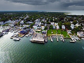
Tisbury is a town located on Martha's Vineyard in Dukes County, Massachusetts, United States. The population was 3,555 at the 2020 census. Along with Chilmark and Aquinnah, West Tisbury forms "Up-Island" Martha's Vineyard.

Chappaquiddick Island Small island at the eastern end of Marthas Vineyard, MA, USA

Chappaquiddick Island, a part of the town of Edgartown, Massachusetts, is a small peninsula and occasional island on the eastern end of Martha's Vineyard. Norton Point, a narrow barrier beach, connects Martha's Vineyard and Chappaquiddick between Katama and Wasque. Occasional breaches occur due to hurricanes and strong storms separating the islands for periods of time. Most recently, the two were separated for 8 years from 2007 to 2015. While both land forms have mostly been connected to one another in modern history, Chappaquiddick is nevertheless referred to as an island.

Wampanoag Native American ethnic group

The Wampanoag, also rendered Wôpanâak, are a Native American people. They were a loose confederation of several tribes in the 17th century, but today Wampanoag people encompass five officially recognized tribes. The Mashpee Wampanoag Tribe and the Wampanoag Tribe of Gay Head in Massachusetts are federally recognized, and the Chappaquiddick, Herring Pond, Assawompsett-Nemasket Band of Wampanoags, and Pocasset Wampanoag Tribe (Pokonoket) are recognized by the Commonwealth of Massachusetts. They lived in southeastern Massachusetts and Rhode Island in the beginning of the 17th century, at the time of first contact with the English colonists, a territory that included the islands of Martha's Vineyard and Nantucket. Their population numbered in the thousands; 3,000 Wampanoag lived on Martha's Vineyard alone.

Menemsha, Massachusetts

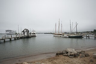
Menemsha is a small fishing village located in the town of Chilmark on the island of Martha's Vineyard in Dukes County, Massachusetts, United States. It is located on the east coast of Menemsha Pond, adjacent to the opening into the Vineyard Sound on the pond's northern end. The village's historic harbor serves as the point of departure for local fishermen, some from multi-generational fishing families, as well as charter boats to the Elizabeth Islands and elsewhere. Besides charter fishing and cruises, other amenities are the public beach adjacent to the harbor and the bicycle ferry across Menemsha Pond to Aquinnah. Menemsha is the location of a United States Coast Guard station, Coast Guard Station Menemsha, and was once known as Menemsha Creek.

Katama is a residential area in the town of Edgartown, Massachusetts, on the south shore of the island of Martha's Vineyard. It is bordered on the west by Edgartown Great Pond, on the east by Katama Bay and on the south by the Atlantic Ocean. It starts at a fork in the road when you head south on Katama Road out of central Edgartown; Katama Road leads to the left and Herring Creek Road leads to the right.

The Islands (Massachusetts)

The Islands is the collective name for the set of large islands south of Cape Cod in the southeast corner of the U.S. state of Massachusetts: Nantucket, Martha's Vineyard, the Elizabeth Islands, and a small number of minor islands. The Islands are the location of numerous beach resorts, celebrity second homes, and preserved buildings dating back to the whaling era.

Edgartown Harbor Light

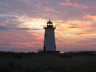
Edgartown Harbor Light is a lighthouse located in Edgartown, Massachusetts, United States, where it marks the entrance to Edgartown Harbor and Katama Bay. It is one of five lighthouses on the island of Martha's Vineyard. The first lighthouse, a two-story wooden structure that also served as the keeper's house, was constructed in 1828. It was demolished, and replaced by the current cast-iron tower, in 1939. Originally located on an artificial island 1/4 miles from shore, the lighthouse is now surrounded by a beach formed, since 1939, by sand accumulating around the stone causeway connecting it to the mainland.

Wasque ("way-squee") or Wasque Beach is a 200-acre (0.81 km2) nature reserve on Chappaquiddick Island, Martha's Vineyard, Massachusetts. The site was established as a reservation for the public in 1967 and is one of five conservation areas on "the Vineyard" managed by the Trustees of Reservations. Wasque contains a sandy strand the Boston Globe calls "a magnificent beach." Travel + Leisure named Wasque Beach the number one beach in New England and WHDH-TV reports "It's pristine, serene, and rain or shine, it's a beach-goers' delight." Off the shore of Wasque Beach is Katama Bay, "a vast and pristine salt water bay that includes many acres of productive shellfish beds."

Gladys A. Widdiss was an American tribal elder, Wampanoag historian and potter. Widdis served as the President of the Aquinnah Wampanoag of Gay Head from 1978 until 1987. She then served as the vice chairman of the Aquinnah Wampanoag tribal council for many years.

Wampanoag Tribe of Gay Head Federally recognized tribe of Wampanoag people located in Massachusetts, USA

The Wampanoag Tribe of Gay Head (Aquinnah) is a federally recognized tribe of Wampanoag people based in the town of Aquinnah on the southwest tip of Martha's Vineyard in Massachusetts. The tribe hosts an annual Cranberry Day celebration.

Edwin DeVries Vanderhoop was a Gay Head, Massachusetts born; American, half Wampanoag Native American - half Surinamese, Civil War Veteran, Politician, Fishermen, Hotel Proprietor, and Whaleman.

Nashaquitsa Pond Salt pond

Nashaquitsa Pond is a salt pond in the town of Chilmark, Massachusetts. Nashaquitsa Pond connects to both Stonewall Pond and Menemsha Pond.

Squibnocket Pond Salt pond

Squibnocket Pond is a salt pond split between the towns of Chilmark, Massachusetts and Aquinnah, Massachusetts. Squibnocket Pond connects to Menemsha Pond via Herring Creek.

Stonewall Pond Salt pond

Stonewall Pond is a salt pond in the town of Chilmark, Massachusetts. Stonewall Pond connects to Menemsha Pond via Nashaquitsa Pond. The beach that separates Stonewall Pond from the Atlantic Ocean is called Stonewall Beach.

References

  1. "PondSummary" (PDF). MV Commission.
  2. "OFFICIALS DETERMINE MENEMSHA POND ANCHORING RULES". NewEnglandBoating.com. New England Boating.
  3. Hufstader, Louisa. "Aquinnah Sites Reveal 10,000 Years of Wampanoag History". The Vineyard Gazette.
  4. Hull, Olivia. "For Islanders, Ties to Coastal Ponds Run Deep". vineyardgazette.com. MV Gazette.
  5. Ritchie, William A. (1969). Archaeology of Martha's Vineyard . NY.
  6. ANNUAL REPORT OF THE CHIEF OF ENGINEERS, UNITED STATES ARMY, TO THE SECRETARY OF WAR, FOR THE YEAR 1892. Washington: GOVERNMENT PRINTING OFFICE. 1892.
  7. "Lobsterville: A History through the Eyes of a Fly Rod (excerpt)". Flogging the Waters.
  8. "Aquinnah: Open for the season". The Martha's Vineyard Times. 2018-05-23. Retrieved 2019-11-24.
  9. Dowd, Brian (2019-03-06). "Chilmark picks new harbormaster". The Martha's Vineyard Times. Retrieved 2019-06-21.
  10. "WINTER FLOUNDER ENHANCEMENT PROJECT". Natural Resource Department. Wampanoag Tribe.