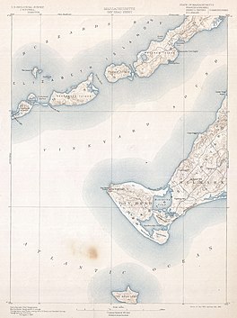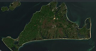
Martha's Vineyard, often simply called the Vineyard, is an island in the Northeastern United States, located south of Cape Cod in Dukes County, Massachusetts, known for being a popular, affluent summer colony. Martha's Vineyard includes the smaller adjacent Chappaquiddick Island, which is usually connected to the Vineyard. The two islands have sometimes been separated by storms and hurricanes, which last occurred from 2007 to 2015. It is the 58th largest island in the U.S., with a land area of about 96 square miles (250 km2), and the third-largest on the East Coast, after Long Island and Mount Desert Island. Martha's Vineyard constitutes the bulk of Dukes County, which also includes the Elizabeth Islands and the island of Nomans Land.

Aquinnah is a town located on the western end of Martha's Vineyard island, Massachusetts. From 1870 to 1997, the town was incorporated as Gay Head. At the 2020 U.S. census, the population was 439. Aquinnah is known for its beautiful clay cliffs and natural serenity, as well as its historical importance to the native Wampanoag people. In 1965, Gay Head Cliffs were designated as a National Natural Landmark by the National Park Service.
Chilmark is a town located on Martha's Vineyard in Dukes County, Massachusetts, United States. The population was 1,212 at the 2020 census. The fishing village of Menemsha is located on the western side of the town along its border with the town of Aquinnah. Chilmark had the highest median home sale price of any town or city in Massachusetts in 2013.
Edgartown is a tourist destination on the island of Martha's Vineyard in Dukes County, Massachusetts, United States, for which it is the county seat.

Oak Bluffs is a town located on the island of Martha's Vineyard in Dukes County, Massachusetts, United States. The population was 5,341 at the 2020 United States Census. It is one of the island's principal points of arrival for summer tourists, and is noted for its "gingerbread cottages" and other well-preserved mid- to late-nineteenth-century buildings. The town has been a historically important center of African American culture since the eighteenth century.

West Tisbury is a town located on Martha's Vineyard in Dukes County, Massachusetts, United States. The population was 3,555 at the 2020 census. Along with Chilmark and Aquinnah, West Tisbury forms "Up-Island" Martha's Vineyard.

Long Island Sound is a marine sound and tidal estuary of the Atlantic Ocean. It lies predominantly between the U.S. state of Connecticut to the north and Long Island in New York to the south. From west to east, the sound stretches 110 mi (180 km) from the East River in New York City, along the North Shore of Long Island, to Block Island Sound. A mix of freshwater from tributaries, and saltwater from the Atlantic Ocean, Long Island Sound is 21 mi (34 km) at its widest point and varies in depth from 65 to 230 feet.

Chappaquiddick Island, a part of the town of Edgartown, Massachusetts, is a small island off the eastern end of Martha's Vineyard. Norton Point, a narrow barrier beach, sometimes connects Martha's Vineyard and Chappaquiddick between Katama and Wasque. Breaches occur due to hurricanes and strong storms separating the islands for periods of time, most recently on December 22, 2022. While both land forms have mostly been connected to one another in modern history, Chappaquiddick is nevertheless referred to as an island.
Katama is a residential area in the town of Edgartown, Massachusetts, on the south shore of the island of Martha's Vineyard. It is bordered on the west by Edgartown Great Pond, on the east by Katama Bay and on the south by the Atlantic Ocean. It starts at a fork in the road when you head south on Katama Road out of central Edgartown; Katama Road leads to the left and Herring Creek Road leads to the right.

The Tiasquam River is a 3.7-mile-long (6.0 km) stream on the southwest of Martha's Vineyard, Massachusetts.
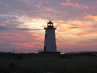
Edgartown Harbor Light is a lighthouse located in Edgartown, Massachusetts, United States, where it marks the entrance to Edgartown Harbor and Katama Bay. It is one of five lighthouses on the island of Martha's Vineyard. The first lighthouse, a two-story wooden structure that also served as the keeper's house, was constructed in 1828. It was demolished, and replaced by the current cast-iron tower, in 1939. Originally located on an artificial island 1/4 miles from shore, the lighthouse is now surrounded by a beach formed, since 1939, by sand accumulating around the stone causeway connecting it to the mainland.

Patchogue Bay is a lagoon on the south-central shores of Long Island in the U.S. state of New York.

The Wampanoag Tribe of Gay Head (Aquinnah) (Wampanoag: Âhqunah Wôpanâak) is a federally recognized tribe of Wampanoag people based in the town of Aquinnah on the southwest tip of Martha's Vineyard in Massachusetts. The tribe hosts an annual Cranberry Day celebration.
Menemsha Pond is a salt pond split between the towns of Aquinnah & Chilmark, Massachusetts. At the mouth of the pond, the Menemsha Creek leads into the Menemsha Bight and the Vineyard Sound. Along Menemsha Creek sits the historic sea-side fishing village of Menemsha. Menemsha Pond connects to both Stonewall Pond via Nashaquitsa Pond and to Squibnocket Pond via the Squibnocket Herring Run.
Edwin DeVries Vanderhoop was a Gay Head, Massachusetts born; American, half Wampanoag Native American - half Surinamese, Civil War Veteran, Politician, Fishermen, Hotel Proprietor, and Whaleman.
Blue Heron Farm is a 28-acre (11 ha)+ acre estate on Martha's Vineyard in Chilmark, Massachusetts, United States, that served as a summer vacation place – the Summer White House – to President Barack Obama and his family during his presidency in 2009, 2010, and 2011. Later, the property was owned by the British architect Norman Foster and his wife Elena Ochoa Foster.

Nashaquitsa Pond is a salt pond in the town of Chilmark, Massachusetts. Nashaquitsa Pond connects to both Stonewall Pond and Menemsha Pond.

Squibnocket Pond is a salt pond split between the towns of Chilmark, Massachusetts and Aquinnah, Massachusetts. Squibnocket Pond connects to Menemsha Pond via Herring Creek.
Tisbury Great Pond is a salt pond in the town of West Tisbury, Massachusetts and oyster restoration site.