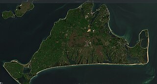
Martha's Vineyard, often simply called the Vineyard, is an island in the Northeastern United States, located south of Cape Cod in Dukes County, Massachusetts, known for being a popular, affluent summer colony. Martha's Vineyard includes the smaller adjacent Chappaquiddick Island, which is usually connected to the Vineyard. The two islands have sometimes been separated by storms and hurricanes, which last occurred from 2007 to 2015. It is the 58th largest island in the U.S., with a land area of about 96 square miles (250 km2), and the third-largest on the East Coast, after Long Island and Mount Desert Island. Martha's Vineyard constitutes the bulk of Dukes County, which also includes the Elizabeth Islands and the island of Nomans Land.

Aquinnah is a town located on the western end of Martha's Vineyard island, Massachusetts. From 1870 to 1997, the town was incorporated as Gay Head. At the 2020 U.S. census, the population was 439. Aquinnah is known for its beautiful clay cliffs and natural serenity, as well as its historical importance to the native Wampanoag people. In 1965, Gay Head Cliffs were designated as a National Natural Landmark by the National Park Service.
Chilmark is a town located on Martha's Vineyard in Dukes County, Massachusetts, United States. The population was 1,212 at the 2020 census. The fishing village of Menemsha is located on the western side of the town along its border with the town of Aquinnah. Chilmark had the highest median home sale price of any town or city in Massachusetts in 2013.
Tisbury is a town located on Martha's Vineyard in Dukes County, Massachusetts, United States. The population was 4,815 at the 2020 census.

West Tisbury is a town located on Martha's Vineyard in Dukes County, Massachusetts, United States. The population was 3,555 at the 2020 census. Along with Chilmark and Aquinnah, West Tisbury forms "Up-Island" Martha's Vineyard.

Chappaquiddick Island, a part of the town of Edgartown, Massachusetts, is a small island off the eastern end of Martha's Vineyard. Norton Point, a narrow barrier beach, sometimes connects Martha's Vineyard and Chappaquiddick between Katama and Wasque. Breaches occur due to hurricanes and strong storms separating the islands for periods of time, most recently on December 22, 2022. While both land forms have mostly been connected to one another in modern history, Chappaquiddick is nevertheless referred to as an island.


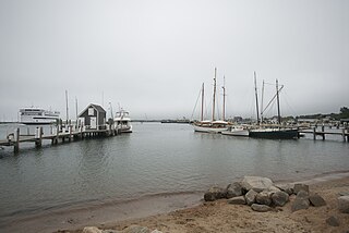
Menemsha is a small fishing village located in the town of Chilmark on the island of Martha's Vineyard in Dukes County, Massachusetts, United States. It is located on the east coast of Menemsha Pond, adjacent to the opening into the Vineyard Sound on the pond's northern end. The village's historic harbor serves as the point of departure for local fishermen, some from multi-generational fishing families, as well as charter boats to the Elizabeth Islands and elsewhere. Besides charter fishing and cruises, other amenities are the public beach adjacent to the harbor and the bicycle ferry across Menemsha Pond to Aquinnah. Menemsha is the location of a United States Coast Guard station, Coast Guard Station Menemsha, and was once known as Menemsha Creek.

The Tiasquam River is a 3.7-mile-long (6.0 km) stream on the southwest of Martha's Vineyard, Massachusetts.
Menemsha Hills is a protected nature reserve located on Martha's Vineyard, Massachusetts in the town of Chilmark. The property is owned by The Trustees of Reservations through three grants of land, the first in 1966. The reserve is adjacent to another Trustees property, The Brickyard.
Experience Mayhew (1673–1758) was a New England missionary to the Wampanoag Indians on Martha's Vineyard and adjacent islands. He is the author of Massachusett Psalter.
United States Coast Guard Station Menemsha is a United States Coast Guard station located in Menemsha, Massachusetts, within the town of Chilmark. Primarily a Search and Rescue unit, other activities include Law Enforcement in commercial fisheries and recreational boating safety. The unit is classified as a Heavy Weather Station, capable of operating in up to 20 foot seas and 50 knots wind.

The Wampanoag Tribe of Gay Head (Aquinnah) (Wampanoag: Âhqunah Wôpanâak) is a federally recognized tribe of Wampanoag people based in the town of Aquinnah on the southwest tip of Martha's Vineyard in Massachusetts. The tribe hosts an annual Cranberry Day celebration.
Legal forms of gambling in the U.S. state of Massachusetts include casinos, sports betting, parimutuel wagering on horse racing, the Massachusetts Lottery, and charitable gaming. The Massachusetts Gaming Commission regulates commercial operations under state jurisdiction.

Martha's Vineyard Transit Authority(VTA) is a bus transportation system serving Martha's Vineyard, Massachusetts. In addition to diesel buses, it has 12 electric buses charged at several points. The Edgartown facility has 700 kW solar panels and a 1.5 MWh battery adding to the bus power.
Menemsha Pond is a salt pond split between the towns of Aquinnah & Chilmark, Massachusetts. At the mouth of the pond, the Menemsha Creek leads into the Menemsha Bight and the Vineyard Sound. Along Menemsha Creek sits the historic sea-side fishing village of Menemsha. Menemsha Pond connects to both Stonewall Pond via Nashaquitsa Pond and to Squibnocket Pond via the Squibnocket Herring Run.
Edwin DeVries Vanderhoop was a Gay Head, Massachusetts born; American, half Wampanoag Native American - half Surinamese, Civil War Veteran, Politician, Fishermen, Hotel Proprietor, and Whaleman.

Squibnocket Pond is a salt pond split between the towns of Chilmark, Massachusetts and Aquinnah, Massachusetts. Squibnocket Pond connects to Menemsha Pond via Herring Creek.
Stonewall Pond is a salt pond in the town of Chilmark, Massachusetts. Stonewall Pond connects to Menemsha Pond via Nashaquitsa Pond. The beach that separates Stonewall Pond from the Atlantic Ocean is called Stonewall Beach.
Tisbury Great Pond is a salt pond in the town of West Tisbury, Massachusetts and oyster restoration site.

