
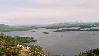
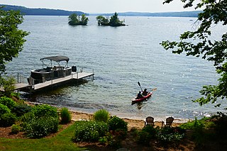
Lake Winnipesaukee is the largest lake in the U.S. state of New Hampshire, located in the Lakes Region at the foothills of the White Mountains. It is approximately 21 miles (34 km) long (northwest-southeast) and from 1 to 9 miles wide (northeast-southwest), covering 69 square miles (179 km2)—71 square miles (184 km2) when Paugus Bay is included—with a maximum depth of 180 feet (55 m). The center area of the lake is called The Broads.
The Lakes Region of New Hampshire is located in the east-central part of the state, south of the White Mountains Region and extending to the Maine border. It is named for the numerous lakes in the region, the largest of which are Lake Winnipesaukee, Lake Winnisquam, Squam Lake, and Newfound Lake. The area comprises all of Belknap County, the southern portion of Carroll County, the eastern portion of Grafton County, and the northern portions of Strafford County and Merrimack County. The largest municipality is the city of Laconia.
The Pemigewasset River, known locally as "The Pemi", is a river in the state of New Hampshire, the United States. It is 65.0 miles (104.6 km) in length and drains approximately 1,021 square miles (2,644 km2). The name "Pemigewasset" comes from the Abenaki word bemijijoasek [bəmidzidzoasək], meaning "where side (entering) current is".
Umbagog Lake is a wilderness lake located in Coös County, New Hampshire, and Oxford County, Maine. It is one of the most pristine lakes in the state of New Hampshire. It lies in the towns of Errol, New Hampshire, and Upton, Maine, as well as the townships of Cambridge, New Hampshire, and Magalloway, Maine. The name Umbagog is properly pronounced with the stress on the second syllable (um-BAY-gog) and is said to come from the Abenaki word for "shallow water". Both "Lake Umbagog" and "Umbagog Lake" are commonly used and accepted when referring to the body of water.
Newfound Lake is located in Grafton County, New Hampshire, United States. It is situated in the Lakes Region of central New Hampshire, in the towns of Alexandria, Bridgewater, Bristol, and Hebron. Its area of 4,451 acres (18.0 km2) places it behind only Lake Winnipesaukee and Squam Lake among lakes located entirely within New Hampshire, and fourth in the state overall, when Umbagog Lake on the Maine border is included.
Lake Winnisquam is in Belknap County in the Lakes Region of central New Hampshire, United States, in the communities of Meredith, Laconia, Sanbornton, Belmont, and Tilton. At 4,214 acres (1,705 ha), it is the fourth-largest lake entirely in New Hampshire. The lake is roughly triangular in shape, with the vertexes pointing north, east, and south. The lake lies along the path of the Winnipesaukee River, which enters the lake from its eastern corner and carries water from Lake Winnipesaukee via Paugus Bay and Opechee Bay. The river also flows south out of Winnisquam's southern corner, eventually joining the Merrimack River. The lake extends several miles north from the course of the Winnipesaukee River, which forms the lake's southeastern side, with the northern point being formed by the confluence of several smaller creeks near the village of Meredith Center. The lake has a maximum depth of 155 feet (47 m).

Lake Wentworth is located in Carroll County in eastern New Hampshire, United States, in the town of Wolfeboro. At 3,097 acres (12.53 km2), it is the seventh-largest lake located entirely in New Hampshire. Water from Lake Wentworth flows through the short Smith River into Crescent Lake and then over the dam into Lake Winnipesaukee in Wolfeboro. The 50-acre (20 ha) Wentworth State Park offers public access to the lake.

Crystal Lake is a 455-acre (1.8 km2) water body located in Belknap County in the Lakes Region of central New Hampshire, United States, in the town of Gilmanton. Crystal Lake is at the head of the Suncook River watershed. Water flows into Crystal Lake from the Belknap Range through Manning and Sunset lakes to the north. Water from Manning Lake enters Crystal Lake via Nelson Brook. Other waterways flowing into Crystal Lake include Wasson Brook and Mill Brook. Water flows out of a dam from the southern end of Crystal Lake via the Suncook Lakes and Suncook River to the Merrimack River. Shoreline development along Crystal Lake consists primarily of summer cottages, with a few year-round residents. Belknap Mountain and Mount Major can be seen from the shoreline.

Goose Pond is a 625-acre (2.5 km2) water body located in Grafton County in western New Hampshire, United States, in the towns of Canaan and Hanover. It is considered a great pond by the state of New Hampshire. The lake has 6.3 miles (10.1 km) of shoreline, and is approximately 3 miles (5 km) long by 0.5 miles (0.8 km) wide. All but the northernmost end of the pond is in the town of Canaan. The average depth of the pond is approximately 10 feet (3.0 m), with the deepest part approximately 35 feet (11 m). The lake is part of the Mascoma River watershed, flowing to the Connecticut River.

Grafton Pond is a 319-acre (1.3 km2) water body located in Grafton County in western New Hampshire, United States, in the town of Grafton. The pond is part of the Mascoma River watershed, flowing to the Connecticut River. Outflow from the pond travels through Bicknell Brook to Crystal Lake in Enfield, then north to the Mascoma River in West Canaan.

On Golden Pond is a 1981 family drama film directed by Mark Rydell from a screenplay written by Ernest Thompson, adapted from his 1979 play of the same name. It stars Katharine Hepburn, Henry Fonda, Jane Fonda, Doug McKeon, Dabney Coleman and William Lanteau. In the film, Norman, a crusty, retired professor grappling with many effects of aging, is estranged from his daughter, Chelsea. At their summer home on Golden Pond, Norman and his wife Ethel agree to care for Billy, the son of Chelsea's new boyfriend, and an unexpected relationship blooms.

Lake Sunapee is located within Sullivan County and Merrimack County in western New Hampshire, the United States. It is the fifth-largest lake located entirely in New Hampshire.

Squam Lakes Natural Science Center (SLNSC) is an environmental education center and zoo founded in 1966 and opened to the public on July 1, 1969. The science center is located in Holderness, New Hampshire, United States. The mission of the science center is to advance understanding of ecology by exploring New Hampshire's natural world.
Lovewell Pond is a sizable body of water located in southeastern Fryeburg, Maine. It has a moderately developed shoreline with approximately 75-80 buildings, not including approximately 35 others with access rights to the pond's shoreline.
Androscoggin Lake is a body of water located in the towns of Wayne and Leeds, Maine. The surface area of the lake is 3,826 acres (1,548 ha). Its greatest length is 4.5 mi (7.2 km) and its greatest width is 2.8 mi (4.5 km). The lake is very shallow with a mean depth of 15 ft (4.6 m) and maximum depth of 38 ft (12 m). The lake temperature is therefore quite warm during summer, and the temperature is the same on the bottom as it is on the top, making it a homothermous body of water. There are 4 islands on the lake: Androscoggin Island, Blodgett Island, Lothrop Island and Norris Island. Norris Island has a cabin that can be reserved for free on tklt.org. The islands support a diverse assemblage of rare species and natural communities. The most extensive areas are along and around the Dead River, which connects the lake to the Androscoggin River. The islands also provide important nesting habitat for bald eagles, ospreys and great blue herons. Lothrop Island's black sand beaches are of geological interest and are also home to several rare plants.

Willard Pond is a small, protected lake in Antrim, New Hampshire, United States. The lake, located in southwestern New Hampshire, is about 108 acres (44 ha) in size with an average depth of 25 feet (7.6 m) and a maximum depth of 58 feet (18 m). No petroleum motors are allowed, and fly fishing is the only form of fishing allowed. It is part of the dePierrefeu Wildlife Sanctuary, which is owned by the New Hampshire Audubon Society. Because the pond and the land around it are part of the sanctuary, the shore is unable to be developed. Therefore, there are no buildings around the pond and there won't be any in the foreseeable future. Willard is instead surrounded by extensive amounts of wilderness and hiking trails that lead around the pond and to the summits of Bald Mountain and Goodhue Hill. Willard is a popular fishing, boating and hiking destination, and it has become more popular with its mention in numerous magazines and newspapers.

Siskiwit Lake is the largest lake on Isle Royale in Lake Superior. 4,150 acres (16.8 km2) in area, the lake has cold, clear water which is relatively low in nutrients. Tributaries include the Little Siskiwit River, and the lake's outlet is the Siskiwit River which flows into Lake Superior.

Camp Carnes is a historic private summer camp in Holderness, New Hampshire. Located on an island in Squam Lake's Carnes Cove off New Hampshire Route 113, the 1894 camp is one of the first to be established on an island in Squam Lake, and forms part of the extensive set of properties owned by the locally prominent Webster family. The camp was listed on the National Register of Historic Places in 2012.

Beech Hill Pond is a lake in Otis, Hancock County, Maine, in the United States. It is 4.5 miles (7.2 km) long, half a mile wide, and up to 104 feet (32 m) deep. Trout, salmon, and other species of fish have been observed in the lake. Bald eagles and loons also live on the shoreline.


