
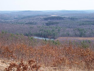
Mount Washington State Forest is a 4,619-acre (1,869 ha) state forest in the Mount Washington, Massachusetts. The forest conjoins with New York state and the state of Connecticut in the southern Taconic Mountains of the southwestern Berkshire region of Massachusetts. In addition to offering recreational and scenic opportunities, the forest lies adajacent to Bash Bish Falls State Park. It is managed by the Massachusetts Department of Conservation and Recreation.
Mohawk State Forest, also known as Mohawk State Forest/Mohawk Mountain State Park, encompasses over 4,000 acres (1,600 ha) in the towns of Cornwall, Goshen, and Litchfield in the southern Berkshires of Litchfield County, Connecticut. As overseen by the Connecticut Department of Energy and Environmental Protection, the area is used for hiking, picnicking, and winter sports by the public, while being actively managed to produce timber and other forest products.

Wells State Park is a public recreation area located off Route 49 in the town of Sturbridge, Massachusetts. The state park includes frontage on Walker Pond and the scenic metamorphic rock cliff face of Carpenter Rocks. Terrain is rugged with ledges interspersed between wetlands. Woodlands are of the oak-hickory forest and northern hardwood forest types with groves of eastern white pine. The park is managed by the Massachusetts Department of Conservation and Recreation.
Chicopee Memorial State Park is a public recreation area covering 562 acres (227 ha) in the Burnett Road neighborhood of the city of Chicopee, Massachusetts. The state park is located directly southeast of Westover Air Reserve Base, which is visible from some parts of the park. It is managed by the Department of Conservation and Recreation.
Beartown State Forest is a publicly owned forest with recreational features located in the towns of Great Barrington, Monterey, Lee, and Tyringham, Massachusetts. The state forest's more than 10,000 acres (4,000 ha) include 198 acres (80 ha) of recreational parkland. It is managed by the Massachusetts Department of Conservation and Recreation.
Mohawk Trail State Forest is a publicly owned state forest in Massachusetts with recreational features located in the towns of Charlemont, Hawley, and Savoy. It covers more than 7,700 acres (3,100 ha) of mountain ridges, gorges, and old-growth forests at elevations ranging from around 600 to 2,080 feet. It is managed by the Department of Conservation and Recreation.
Monroe State Forest is a Massachusetts state forest forest with recreational features located in the towns of Monroe and Florida. A small portion of the borders the state of Vermont. The forest is managed by the Department of Conservation and Recreation.

Mount Everett State Reservation is a public recreation area in the towns of Mount Washington and Sheffield, Massachusetts, that offers panoramic views of Massachusetts, Connecticut, and New York from the summit of 2,624-foot (800 m) Mount Everett. The reservation abuts Jug End State Reservation and Wildlife Management Area; Bash Bish Falls State Park and Mount Washington State Forest lie to the west. All are managed by the Massachusetts Department of Conservation and Recreation.

Lake Dennison Recreation Area is a 121-acre (49 ha) Massachusetts state park located in the town of Winchendon. It comprises a small portion of the 4,221 acres (1,708 ha) of the U.S. Army Corps of Engineers' Birch Hill Flood Control Project that are managed by the Department of Conservation and Recreation and that also include Otter River State Forest.

Leominster State Forest is a publicly owned forest with recreational features covering 4,246 acres (1,718 ha) in the Massachusetts towns of Leominster, Fitchburg, Princeton, Sterling, and Westminster. The state forest encompasses an extensive trail system, numerous small ponds, and the Crow Hills. Plants such as mountain laurel are common as is an abundance of wildlife. The forest is headquarters for Massachusetts Bureau of Forest Fire Control District 8 and is managed by the Department of Conservation and Recreation.

Wendell State Forest is a Massachusetts state forest located in the town of Wendell. The 7,566-acre (3,062 ha) parcel occupies a forested and hilly upland plateau south of the Millers River and west of the Quabbin Reservoir. Park roads were developed by the Civilian Conservation Corps in the 1930s.

Cutler Park is a state-owned nature preserve and public recreation area that lies between Route 128/I-95 and the Charles River in Needham, Massachusetts. The state park's 739 acres (299 ha) contain the largest remaining freshwater marsh on the middle Charles River. Parts of its major trail run directly through the marsh via boardwalks; over 100 species of birds have been sighted here. The park is part of a plan by the Town of Needham to connect 18 public areas by 35 proposed trails. It is managed by the Massachusetts Department of Conservation and Recreation.

Burr Pond State Park is a public recreation area covering 438 acres (177 ha) adjacent to Paugnut State Forest in the town of Torrington, Connecticut. The state park surrounds Burr Pond, an 85-acre (34 ha), man-made body of water with facilities for swimming, boating, and fishing. It is managed by the Connecticut Department of Energy and Environmental Protection.

Tolland State Forest is a publicly owned forest with recreational features covering 4,415 acres (1,787 ha) in the towns of Otis, Tolland, Blandford and Sandisfield in the southern Berkshire Hills of Massachusetts. The state forest centers on the 1,065-acre (431 ha) Otis Reservoir, the largest body of water for recreational use in western Massachusetts. The forest is managed by the Department of Conservation and Recreation.

Pearl Hill State Park is a 1,000-acre (400 ha) Massachusetts state park located in the town of Townsend about 50 miles (80 km) from Boston. The park lies adjacent to Willard Brook State Forest and is managed by the Department of Conservation and Recreation (DCR).
Lowell-Dracut-Tyngsboro State Forest is a publicly owned forest with recreational features measuring 1,109 acres (449 ha) that overlap the City of Lowell, and the towns of Dracut and Tyngsborough, Massachusetts. The forest, which includes some 180 acres (73 ha) of ponds, swamps and wetlands, is maintained by the Massachusetts Department of Conservation and Recreation.

Harold Parker State Forest is a publicly owned forest with recreational features encompassing more than 3,300 acres (1,300 ha) in the towns of Andover, North Andover, North Reading, and Middleton, Massachusetts. Ponds, swamps, rolling hills, glacial erratics and rocky outcroppings can be found in the state forest, which features more than 35 miles (56 km) of backwoods roads and trails as well as remnants of 18th-century farming and milling operations. It is managed by the Massachusetts Department of Conservation and Recreation.

Pittsfield State Forest is an 11,000-acre (4,500 ha) Massachusetts state forest located in the town of Pittsfield and managed by the Department of Conservation and Recreation. The forest is the location of Berry Pond, which sitting atop Berry Mountain at an elevation of 2,150 feet (660 m) is the highest natural body of water in the state.

The Labrador Hollow Unique Area is a 1,474-acre (5.97 km2) conservation area located in Cortland and Onondaga counties, New York, and was the first property to be designated as a Unique Area by New York. The area is located adjacent to and between Kettlebail State Forest and Morgan Hill State Forest, and is managed by the New York State Department of Environmental Conservation. The area is open to the public and includes Labrador Pond and Tinker Falls.
Beebe Hill State Forest is a state forest in the town of Austerlitz, Columbia County, New York, United States. Compromising 1,383 acres (560 ha) in the Taconic Mountains, it adjoins Harvey Mountain State Forest to the southeast. With around 30 mi (48 km) of multiple-use trails, the area is managed for environmental protection, recreation, and timber harvesting. The 6.5-acre (2.6 ha) Barrett Pond is located within the state forest on the west side of Columbia County Route 5, and was home to numerous fish species when last sampled in 1983.


