
Mashpee is a town in Barnstable County, Massachusetts, United States, on Cape Cod. The population was 15,060 as of 2020. The town is the site of the headquarters and most members of the Mashpee Wampanoag Tribe, one of two federally recognized Wampanoag groups.

New Seabury is a census-designated place (CDP) in the town of Mashpee in Barnstable County, Massachusetts, United States, on Cape Cod. The area consists primarily of summer homes for wealthy families. Attractions include a county club and the Fells Pond, Daniels Island, and Littleneck Bay neighborhoods. The population of the CDP was 717 at the 2010 census. The community is located on the historic home of the Wampanoag Nation. The New Seabury area is often extended to include Popponesset and Popponesset Island, which are only accessible by road through New Seabury and are part of the New Seabury development, but are grouped separately for Census purposes.

The Trustees of Reservations is a non-profit land conservation and historic preservation organization dedicated to preserving natural and historical places in the Commonwealth of Massachusetts. It is the oldest land conservation nonprofit organization of its kind in the world and has 100,000 member households as of 2021. In addition to land stewardship, the organization is also active in conservation partnerships, community supported agriculture (CSA), environmental and conservation education, community preservation and development, and green building. The Trustees owns title to 120 properties on 27,000 acres (11,000 ha) in Massachusetts, all of which are open to the public. In addition, it holds 393 conservation restrictions to protect an additional 20,000 acres (8,100 ha). Properties include historic mansions, estates, and gardens; woodland preserves; waterfalls; mountain peaks; wetlands and riverways; coastal bluffs, beaches, and barrier islands; farmland and CSA projects; and archaeological sites.

Weir Hill Reservation is a 194-acre (0.79 km2) public park located in the town of North Andover, Massachusetts. The Trustees of Reservations owns and maintains the property.

Waquoit Bay is a public national estuary, which is typically used as a research reserve. It is a part of Nantucket Sound and is located on the southern shore of Cape Cod in Massachusetts, USA. This bay forms the border of the towns of Falmouth and Mashpee, Massachusetts.

The Quashnet River, also known as Quoshnet River or Moonakis River, is a 5.1-mile-long (8.2 km) estuary in Falmouth, Massachusetts on Cape Cod. Its area is about 1-square-mile (2.6 km2).

The Mashpee River is a 4.8-mile-long (7.7 km) tidal river on Cape Cod in Mashpee, Massachusetts.

Mytoi is a small Japanese garden set within an open pine forest on Chappaquiddick Island, in Martha's Vineyard, Massachusetts. The Trustees of Reservations owns and maintains the property.

The Charles W. Ward Reservation is a 704-acre (285 ha) open space reserve located in Andover and North Andover, Massachusetts, 20 miles (32 km) north of Boston. The reserve, managed by the land conservation non-profit organization The Trustees of Reservations, is notable for its open drumlin hilltops and vistas encompassing Boston and Salem. The Ward Reservation offers 13 miles (21 km) of trails and former woods roads available for hiking, horseback riding, mountain biking, and cross country skiing; it is also a link in the 200-mile (320 km) Bay Circuit Trail system.
McLennan Reservation is a nature reserve located in Otis and Tyringham, Massachusetts. The property is owned by The Trustees of Reservations through a series of endowments for preserving the land, the first in 1977. The reservation is adjacent to another Trustees property, Ashintully Gardens.

Whitney and Thayer Woods is a 834 acres (338 ha) nature reserve and forest located in Cohasset and Hingham, Massachusetts. The property is owned by The Trustees of Reservations. It is adjacent to the Weir River Farm, also owned by The Trustees, and Turkey Hill, a town-owned property managed by The Trustees. The woods include 10 miles (16 km) of walking trails.

Tyringham Cobble is a 206-acre (83 ha) open space reservation located in Tyringham, Massachusetts on 411 m (1,348 ft) Cobble Hill in The Berkshires. It is managed by The Trustees of Reservations, a non-profit conservation organization, and is notable for its scenic views over the rural landscape of Tyringham Valley from rocky ledges and open fields. The reservation consists of the hill and surrounding agricultural and pasture land. In 2008, part of the 2,175 mile (3,500 km) Appalachian Trail was routed over the summit ledges.
Royalston Falls is a 50 foot (15 m) waterfall and granite gorge located in Royalston, Massachusetts along Falls Brook, a tributary of the Tully River which in turn is a tributary of the Millers River. The falls are part of a 217-acre (88 ha) open space preserve acquired in 1951 by the land conservation non-profit organization The Trustees of Reservations. The 22-mile (35 km) Tully Trail and the 235-mile (378 km) New England National Scenic Trail pass through the property.
Wasque or Wasque Beach is a 200-acre (0.81 km2) nature reserve on Chappaquiddick Island, Martha's Vineyard, Massachusetts. The site was established as a reservation for the public in 1967 and is one of five conservation areas on "the Vineyard" managed by the Trustees of Reservations. Wasque contains a sandy strand the Boston Globe calls "a magnificent beach." Travel + Leisure named Wasque Beach the number one beach in New England and WHDH-TV reports "It's pristine, serene, and rain or shine, it's a beach-goers' delight." Off the shore of Wasque Beach is Katama Bay, "a vast and pristine salt water bay that includes many acres of productive shellfish beds."

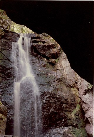
Doane's Falls is a series of five waterfalls located in Royalston, Massachusetts along an 0.2-mile (0.32 km) section of Lawrence Brook, a tributary of the Millers River that originates from Laurel Lake in Fitzwilliam. The falls are part of a 46-acre (19 ha) open space preserve acquired in 1959 by the land conservation non-profit organization The Trustees of Reservations. The 22-mile (35 km) Tully Trail passes through the property.
Jacobs Hill is a 173-acre (70 ha) open space preserve in Royalston, Massachusetts acquired in 1975 by the land conservation non-profit organization The Trustees of Reservations. The preserve includes scenic vistas, ledges, woodlands, a northern bog, and Spirit Falls, a 30 foot (9.1 m) waterfall. The 22-mile (35 km) Tully Trail passes through the property. Views from the ledges include the Berkshires as well as nearby Long Pond and the Tully River Valley, Tully Mountain, and Mount Grace.

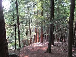
The Lowell Holly Reservation is a 135-acre (0.55 km2) nature reserve in Mashpee and Sandwich, Massachusetts and is managed by the Trustees of Reservations. The area was extensively planted by A. Lawrence Lowell and Wilfred Wheeler with rhododendrons, mountain laurel and holly trees, for which the reservation gets its name. There are 4 miles (6.4 km) of hiking trails and two peninsular knolls that jut into Mashpee Pond and Wakeby Pond. Lowell bequeathed the property to the Trustees of Reservations in 1943.

The Rock House Reservation is a 196-acre (79 ha) open space preserve located in West Brookfield, Massachusetts. The property, acquired in 1993 by the land conservation non-profit organization The Trustees of Reservations, is named for a natural rock shelter once used as a winter camp by Native Americans. Its location near two, long Native American footpaths suggests that it may also have been a trail camp and meeting place.

The Swift River Reservation is a 439-acre (178 ha) open space preserve located in Petersham, Massachusetts, United States. The property, named after the East Branch of the Swift River, is managed by the land conservation non-profit organization The Trustees of Reservations and offers 7 miles (11 km) of trails available for hiking, horseback riding, mountain biking, and cross country skiing. Ledges, river corridor, woodlands, scenic vistas, and wetlands characterize the preserve.

Appleton Farms is a park in Ipswich, Massachusetts, owned and maintained by The Trustees of Reservations. The property was deeded to the Trustees in 1998. The land was granted to Samuel Appleton, an immigrant from Little Waldingfield, England, in 1638 by the town of Ipswich and is one of the oldest continuously operating farms in Massachusetts. In 2002, The Trustees of Reservations established a vegetable Community Supported Agriculture Program. Also maintained by the Trustees of Reservations is the adjacent Appleton Farms Grass Rides. The properties include 4 miles (6.4 km) of walking trails.
